You are viewing the expanded version of this Harbour,
for faster browsing
use the regular version here


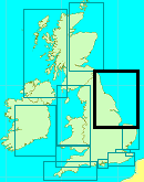
Spurn Head Anchorage (including Approaches to the River Humber)
Courtesy Flag
Flag, Red EnsignWaypoint
Approach to Spurn Head Anchorage 53:34'.585 N 000:06'.2 ECharts
Admiralty, 1188Rules & Regulations
See Full Bye Laws. www.humber.comHazards
Fierce Tides and Shipping amongst others.Tidal Data Times & Range
Hull -0050 (Approx) MHWS 6.9m, MHWN 5.5m, MLWN 2.7m, MLWS 1.2m (links)This site is designed for slower, roaming broadband connections, like you would get at sea, so it needs JavaScript enabled to expand the text.
General Description
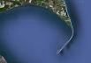
Spurn Head is the promontory guarding the mouth of the River Humber.
It is included in this series as it could prove to be a very useful passage Anchorage if trying to make your way North and beset by contrary winds.
The Anchorage provides good shelter with winds from the north-east, North and possibly NNW. It can be a bit exposed however if the wind pipes up from other directions.
It could provide a temporary Anchorage while you await a suitable rise of tide to enter the Marina at Grimsby.
Although the powerful tides roar around Spurn Head at speeds of over 4 kn on the ebb during springs, the Anchorage is outside the mainstream.
There is little or nothing in the way of facilities, but it could save the Mariner pushing into the Humber and thus save time if on passage.
Approach
Any kind of approach to the River Humber needs a good study of the charts......
.... to understand the various well buoyed shipping lanes in the approaches. The small craft Mariner, even at low water can keep out of and skirt the edges of these lanes.
Plilotage directions for entering the Humber..
Approaching from the South it is easy enough to keep well clear of the shipping lanes, and indeed, if going to Grimsby, there is no need to get involved at all. If heading for the Spurn Head Anchorage the shipping could be tackled from the area of Bull Sand Fort, marked by two cardinal buoys.
One point worth noting if approaching from the South is to be aware of the Tetney Monobuoy (52°32'.36N 000°06'.76E this position as per the ABP list of buoys 28/03/2019). This is used by large tankers, and when not in use has a floating pipeline that can extend 290 m from the buoy. The pipeline is marked by quick flashing yellow lights, and the buoy itself is lit 2 VQ.Y(Vert). Small craft should give it a very wide berth.
If the tide is flooding fast you could commence your crossing from the northerly Cardinal light float Bull (VQ.6). Steering a north-easterly course from here with the tide pushing you inwards should get you to the Anchorage.
Crossing the shipping channel here gives you a very good view of what is coming and going, and plenty of water to lurk around in while waiting your opportunity to dart across.
Approaching from the North, providing you keep well clear of the Outer Binks that radiates eastwards from Spurn Head, you should be able to pick up and parallel the edge of the shipping channel as defined by the Spurn easterly Cardinal light float, the South East Chequer southerly Cardinal light float, and the Chequer southerly Cardinal buoy. The shallows of the Outer Binks Sands can produce very rough seas that are best avoided by small craft altogether.
There can be tidal eddies in the region of The Chequer buoy, also to the north of the shipping channel between Chequer Shoal and Spurn Head. These tidal eddies can be dangerous for small craft. It is however assumed the skipper has done his tidal calculations and is approaching Spurn Head either at slack water or with the tide under him.
The tidal flow around Spurn Head is slack at around high water Hull, but then commences its outpouring immediately... reaching a maximum of over 4.3 kn three hours after high water Hull (at spring tides, neaps 2.5 kn maximum). Six hours after high water Hull there is still a significant outflow in this immediate region, up to 1.8 kn.
At six hours before high water Hull the tidal flows are slack around Spurn Head, but by three hours before high water Hull they can increase to inflow of 3.8 kn at Springs and 1.7 kn at neaps.
It would therefore be a complete waste of time trying to force your way in against the powerful ebbing tide, furthermore you would be exposing yourself to unpredictable tidal eddies too. Six hours before high water Hull to high water Hull is the window for pushing your way in here.
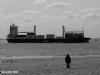
Shipping permitting there is nothing to prevent you encroaching into the channel a little if you have to... at least you're going the right direction. It does need to be noted however that sometimes large deep draught ships have to use the wrong side of the Channel between Spurn Head and the Spurn Light Float.
It would be extremely wise to monitor VTS Humber on VHF Channel: 14 and 16 for traffic movements. A link is given below to the page on the official Humber websites that deals with advice and regulations for small craft, this should be studied:
http://www.humber.com/Yachting_and_Leisure/Pleasure_Craft_Navigation/
Berthing, Mooring & Anchoring
Once safely past Spurn Head you will see various moorings and the jetty.....
..... tuck in and find your anchorage, there is still (2019) a yellow, small craft mooring buoy available. Keep well clear of all official operations.
Thanks are due to those who have made suggestions below about this anchorage - use these and your own judgement remembering that, if you are arriving here at the end of the flood with the intention of leaving at the beginning of the next one, there can be as much as 6m range at Spring tides. You don't want to wake up and find you have to wait until you float to make a dash for Hull.
The Anchorage lies due West of the pilot jetty, and the two disused lighthouses shown clearly on the chart and in the photos form a useful transit. Anchoring to the North of this transit line could mean touching the bottom at LWS.
There is however quite a large area where you can anchor in over 2 m at CD. Tidal streams in this area are negligible.
If the wind is in the NW it's possible to move up the Humber a bit and find protection close to the north bank near Hawkins Point. This is the only area on the Lower Humber where any protection can be gained from north-westerly winds. This is shown on the larger chart.
Facilities
There are no facilities available here to speak of, the nearest being about 5 miles away. It is easy enough to get ashore, the only inhabitants being paid staff of the lifeboat service. Humber VTS has it's control tower here too.
The area does gets plenty of day visitors by car in nice weather.
History
Spurn Point (or Spurn Head as it is also known) is a narrow sand spit on the tip of the coast of the East Riding of Yorkshire, England that reaches into the North Sea and forms the north bank of the mouth of the Humber estuary. It is over 3 miles (4.8 km) long, almost half the width of the estuary at that point, and as little as 50 yards (46 m) wide in places. The southernmost tip is known as Spurn Head or Spurn Point and is the home to an RNLI lifeboat station and disused lighthouse. It forms part of the civil parish of Easington.
Spurn Head covers 113 hectares (1.13 km2) above high water and 181 hectares (1.81 km2) of foreshore. It has been owned since 1960 by the Yorkshire Wildlife Trust and is a designated National Nature Reserve, Heritage Coast and is part of the Humber Flats, Marshes and Coast Special Protection Area.
History
In the Middle Ages, Spurn Head was home to the port of Ravenspurn (aka Ravenspur or Ravensburgh), which was the site of Edward IV's landing on March 14, 1471, when he returned from his six months' exile in the Netherlands. An earlier village, closer to the point of Spurn Head, was Ravenser Odd. Along with many other villages on the Holderness coast, Ravenspurn and Ravenser Odd were lost to the encroachments of the sea, as Spurn Head, due to erosion and deposition of its sand, migrated westward.
The lifeboat station at Spurn Head was built in 1810. Owing to the remote location, houses for the lifeboat crew and their families were added a few years later. The station is now the only one in the UK which has full-time paid staff.
Spurn Head from the air in 1979
In World War I two coastal artillery 9.2-inch (230 mm) batteries were added at either end of Spurn Head, with 4-inch (100 mm) and 4.7-inch (120 mm) quick firing guns in between. The emplacements can be clearly seen, and the northern ones are particularly interesting as coastal erosion has partly toppled them onto the beach, revealing the size of the concrete foundations very well. The Information Centre has a leaflet describing the defences.
As well as a road, the peninsula also used to have a railway, parts of which can still be seen. Unusual 'sail bogies' were used as well as more conventional light railway equipment.
Geography
The peninsula is made up from sand and shingle eroded from the Holderness coastline washed down the coastline from Flamborough Head. Material is washed down the coast by longshore drift and accumulates to form the long, narrow embankment in the sheltered waters inside the mouth of the Humber estuary. It is maintained by plants, especially Marram grass (Ammophila arenaria). Waves carry material along the peninsula to the tip, continually extending it; as this action stretches the peninsula it also narrows it to the extent that the sea can cut across it in severe weather. When the sea cuts across it permanently, everything beyond the breach is swept away, only to eventually reform as a new spit pointing further south. This cycle of destruction and reconstruction occurs approximately every 250 years.
The second of the Six Studies in English Folk Song for Cello composed in 1926 by Ralph Vaughan Williams, the Andante sostenuto in E flat "Spurn Point" celebrates this peninsula.
It was featured on the television programme Seven Natural Wonders as one of the wonders of Yorkshire.
Ecology
The mud flats are an important feeding ground for wading birds, and the area has a bird observatory, for monitoring migrating birds and providing accommodation to visiting birdwatchers. Their migration is assisted by east winds in autumn, resulting in drift migration of Scandinavian migrants, sometimes leading to a spectacular "fall" of thousands of birds. Many uncommon species have been sighted there, including a Cliff Swallow from North America, a Lanceolated Warbler from Siberia and a Black-browed Albatross from the Southern Ocean. More commonly, birds such as Wheatears, Whinchats, Common Redstarts and flycatchers alight at Spurn on their way between breeding and wintering grounds elsewhere. When the wind is in the right direction migrants are funnelled down Spurn Point and are counted at the Narrows Watchpoint, more than 15000 birds can fly past on a good morning in autumn with 3000 quite normal.
The text on this HISTORY page is covered by the following licence
http://en.wikipedia.org/wiki/Wikipedia:Text_of_the_GNU_Free_Documentation_License
Eating, Drinking & Entertainment
There used to be a small cafe established in a large caravan on the site, so you may well be able to stretch your legs and get a bite to eat but local information indicates that this facility has been discontinued - please let us know if it starts up again.
Links
|

Your Ratings & Comments
The RNLI still maintain their only permanently manned lifeboat at Spurn and it is moored close to the yacht anchorage, perhaps a comfort for some.
The pilot boats still use the jetty from time to time and the "yacht buoy" is still available, those who moor to it say use a long warp to avoid bumping as the tide turns.
SANUTI
CR579
53 32.364N 00 06.760E. (source Humber.Com)
If wind from the NW to NE you may prefer to anchor close in to Hawkins Point for a quieter anchorage than off the Spurn Pilot Jetty.
If you require the flood to go up River. Bestt leave this location LW Immingham + 1 hour. The ebb runs for about 45 mins. after "book" LW Immingham.
Oil tankers discharging on the SBM will be in the region of 245m loa. With a tug made fast aft throughout his stay. The tug and his towing gear stretched will be another 50m+.
Rgds.
As an alternative I'd consider anchoring SW of the Bull Anchorage. Lincolnshire affords some shelter from SW'lys. However the fast craft working out of Grimsby to the wind farms still supply the wash effect for you. Regards.
Large or fast vessels using the Sunk Dredged Channel could also pose a problem with their wash as they round the Point close in. You are also very close to the 10m contour at the quoted waypoint.
Have anchored N53 34 740 E00 06.100 to the north of the Sunk Dredged Channel buoy line well clear of shipping 3.0m CD.
Humber VTS Ch.14 best contacted prior anchoring for confirmation that you're clear of the SDC approaches.
The current recommended anchorage for leasure craft is now abt. 2.5 cables north of West Walker Dyke Lt., clear of the commercial shipping lanes. 0.5m CD
(I have also anchored to the North of Whitton Island also well clear of commercial vessels.)
TETNEY MONO MOORING 53 32.364 N 00 06.760 E
it should be:
LATITUDE = 53 32.349N
LONGITUDE = 00 06.770E