

Harbour Information (use the  icons to find out more)

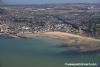
Margate Harbour
Your Comments: 6 Read or add your comments
Courtesy Flag
Flag, Red EnsignWaypoint
None GivenCharts
Admiralty 1827, 1607, SC5606Rules & Regulations
UnknownHazards
Harbour Dries, Exposed from W to NTidal Data Times & Range
Approx. Dover + 0110 MHWS 4.8m, MHWN 3.9m, MLWN 1.4m, MLWS 0.5m (links)This site is designed for slower, roaming broadband connections, like you would get at sea, so it needs JavaScript enabled to expand the text.
General Description
Margate Harbour is a small drying site with limited protection, lying a couple of miles to the west of North Foreland. ... read more
Approach
If coming from the East and passing or rounding the North Foreland.... ... read more
Berthing, Mooring & Anchoring
The inside of the breakwater is not really suitable for laying a keelboat alongside..... ... read more
Your Ratings & Comments
6 comments
Update May 2022
Written by Don Thomson 3 | 9th May 2022
No changes
UPDATE SPRING 2021
Written by Don Thomson 3 | 18th Mar 2021
2021 No changes
UPDATE SPRING 2018
Written by Don Thomson | 29th Mar 2018
No changes but new charts have been uploaded
Update Spring 2016
Written by dononshytalk | 21st Mar 2016
These notes were reviewed by Don in March 2016. There are no improvements to the facilities for visiting yachts here and none in the pipe line.
Update April 2014
Written by dononshytalk | 11th Apr 2014
These notes were reviewed in April 2014 and no changes made.
Update 2013
Written by dononshytalk | 19th Mar 2013
These notes were reviewed by Don T on 19th March 2013 and no changes made.

© visitMyHarbour.com | website design created by Black Culm Ltd