NEW Buy 2024 Unified Charts
![]()
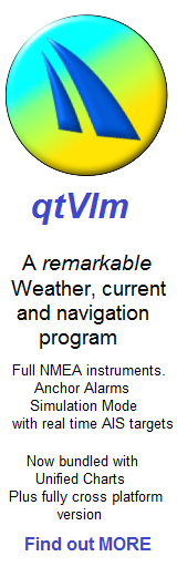
New ! Default easy install program, qtVlm is bundled... and it can do a lot of things the others can't... give it a try !
Download NOW...
NEW: 2024 Editions
![]()
Only want Android....see HERE
![]()
Buy and keep physical USB, Click HERE
Logged in MEMBERS please go HERE
DOWNLOAD versions: ![]() You could be up and running within in an hour on Windows(not XP)
You could be up and running within in an hour on Windows(not XP)
Downloads are HUGE. You need good broadband.
Change-log:
30th July 2017 Downloads all rebuilt with Windows signed software drivers.
12th March 2018 2018 versions released. Auto activate Android charts bundled, with Android unlocks sent by post with a printed receipt. Price up by £1 to cover.
15th April 2018 New support for qtVlm program, bundled as default easy install package on USB. Work in progress to upgrade download versions to same spec.
19th April 2018 Download versions now ready with qtVlm support .
23rd Jan 2020 Ability for VMH to de-activate and re-issue installations (£10 fee). FREE intital update for current edition.iso images now finally possible by download in Jan the following year.
20th July 2021. Support stopped for very old or non official relase versions of OpenCPN. Supported version include 4.4.0 and latest version 5.6.2 among others.
10th May 2023. Support added for OpenCPN 5.8.2 current version1st May 2023. Support finally removed for all OpenCPN versions 4.
25th July 2023 Support added for OpenCPN 5.8.4 released Mid June 23. Support added for Windows using ARM processors.
20th Sept 2023. Download versions. Unlocks for the bundled Marine Navigator charts are now also delivered on purchase
Skill level required: Basic Windows skills will be required to "mount" the virtual DVD image and "point" your chosen programs at the chart packages on it. Before purchase make sure you test compatibility
Coverage:
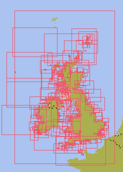
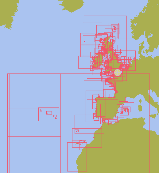
UK and Ireland
.
.
This 2024UK/Ireland edition contains over 826 raster charts, dated 1st Jan 2024.
Before purchase please:
test compatibility 
£33.00 by download MEMBERS please go HERE £23
Buy and keep physical USB, Click HERE
Important note: Although the French coasts are visible, there is not enough detail to approach these coasts safely. If visiting France you WILL need the package below:.
.
.
.
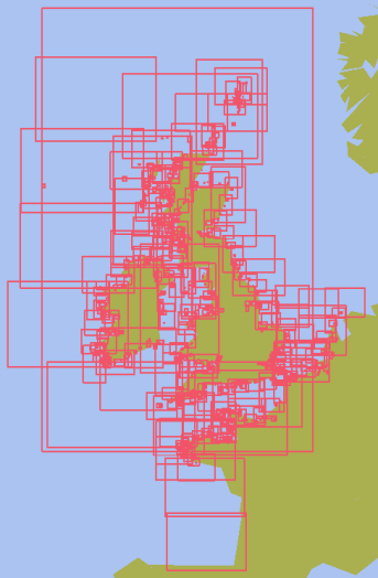
.UK and Near Continent
.
.
.
.
.
This Channel France/UK/Ireland/Belgium/Netherlands edition contains over 1010 charts. UK Jan 2024. BE, NL,FR Dec 2023,
Before purchase please:
test compatibility
Coverage: UK/Ireland/Channel France/ Belgium, 100% at all scales available. French coverage at all available scales, starts at Brest and extends to Belgium. Small scale French coverage down towards Spain.
£49 by download MEMBERS please go HERE £39
Buy and keep physical USB, Click HERE
.
.
.
.
.
.
.
.
.
.Ce produit : - contient toutes les cartes marines, à grande, moyenne, et petite échelle, pour les côtes Françaises, depuis la frontière Belge jusqu'aux Iles des Glénan incluses. Contient 5 cartes marines à moyenne échelle ou à grande échelle pour la zone sud des Iles des Glénan jusqu'à la frontière Espagnole. Ne contient pas de cartes marines détaillées, à petite échelle, pour le reste de la façade Atlantique des côtes Françaises.
.
For the avoidance of doubt: Our Netherlands coverage in this and any other product is shown below:
![]()
.No freshwater inland coverage. Fine for coastal passagemaking.
.
.
.
.
.
.
.
.
.
.
.
"ALL" UK, Near Continent, inc. Atlantic France & Iberia & Atlantic Islands
NEW . bundled for free a set of 20+ Atlantic planning charts
This France (Manche et Atlantique) UK/IRL/BE/NL/ES/P chartset combines all the charts, over 1,350 of them into one package. FR, BE-NL-ES-PT charts are dated Dec 2023, UK Jan 2024.
Before purchase please:
test compatibility
Price £71 by download
MEMBERS please go HERE £61
Buy and keep physical USB, Click HERE
.
.
.
.
.
.
.
ALSO NOW INCLUDED IN THIS PACKAGE:
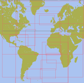
Existing packs contain full coverage of Azores, Cararies, Maderia
Now also: Full coverage of Cape Verde Islands. Bonus.. 24+small scale N and S Atlantic 2018 planning charts included free. These tie everything else together nicely.
This package is ideal for Trans Atlantic Ocean planning
* L'acheteur du téléchargement dispose d'une licence avec deux codes d'activation. Un code pour la copie de travail, et un code de sauvegarde.
* Chaque code permet d'installer la licence sur une machine.
* Le code de sauvegarde peut être utilisé, SANS PROBLEME, sur une machine différente de la machine de travail, si la machine de travail tombe en panne.
* Une fois installée sur une machine, la licence ne peut être déplacée sur une autre machine.
* Une fois qu'un code a été utilisé, pour installer la licence sur une machine, il ne peut jamais être utilisé à nouveau.
Unified Charts will work with standard versions of the following:

Marine Navigator qtVlm SeaClear OpenCPN Polar View Expedition
.
.
.
Notices for French charts
« Aucun service hydrographique officiel n’a vérifié les informations contenues dans ce document et ne peut être tenu responsable de la fidélité de leur reproduction ou de toute modification ultérieure. La possession de ce produit dérivé n’exonère pas de l’obligation d’utiliser les documents nautiques appropriés prévus par les règlements nationaux ou internationaux ». "No official Hydrographic Office has verified the information contained in this document and can not be held responsible for the accuracy of reproduction or any subsequent amendment. Possession of the derivative does not exempt from the obligation use appropriate nautical documents required by national laws or International ".
« Ce produit intègre des données © SHOM – 3/2015 – reproduites avec l’autorisation n° 6/2015 » "This product incorporates data © SHOM - Dec / 2016 - reproduced with authorization No. 6/2015 "
on USB, portable between Windows machines. £10 more than download... BUT more versatile !

Unified Charts on USB a portable, easy to use way of providing "For Navigation" Raster charts, that are compatible with some fantastic free (or very cheap) navigation programs.
Superb time tested compatibility with ALL Windows versions Vista to W10.
This tiny USB dongle is an unusual way of delivering navigation chart packages for Windows machines. Adds £10 plus delivery to the cost, but Windows charts are locked to the USB, thus portable between machines. Coverage same as the download versions above, Marine Navigator charts are bundled for Android installation (2 Devices max)
See area coverage maps further up this page
Buy the USB version NOW. choose your coverage
Price show below is the Unified Charts, and the USB dongle. .
Skill level required: Plug in the USB, and "point" your chosen programs at the chart packages on it ! Android installation requires carefully following instructions and patience.
Dispatch Time: Normally sent by the next working day, 1st class post.
Remember the 30 day "No Quibble" money back guarantee. If the coverage, quality, or anything else about a Unified Charts USB disappoints you, just return for a full refund. No problems or questions.
"The very model for distribution of raster charts is Visitmyharbour.com == a small company based right here in Cowes where I am now. They sell fully updated and officially "for navigation" raster charts of the entire UK plus Belgium and Netherlands for 60 pounds == more than 1000 charts. With a year of free updates. They also sell cheaply or give away tons and tons and tons of other extremely useful navigation and pilotage information == this company is an absolutely fantastic resource. Unfortunately! They are only slowly expanding their coverage, and haven't gotten to the Baltic yet."
Cruisers Forum
Article Info
Related articles