

Harbour Information (use the  icons to find out more)

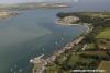
Courtmacsherry Bay
Your Comments: 7 Read or add your comments
Courtesy Flag
Irish TricolourWaypoint
None GivenCharts
AC 2092 Toe Head to Old Head of Kinsale, AC2081 Courtmacsherry Bay, SC 5622, Imray C56 Cork to Dingle Bay (includes Plan of Courtmacsherry)Rules & Regulations
None KnownHazards
Bullens Bay (north of Holeopen Bay East) is full of rocks out to 3 cables off shore. The bay to the north of Holeopen Bay West is also full of rocks. The middle of Courtmacsherry is littered with rocks with the Barrel Rocks marked by a SCM and Black Tom by a SHM (buoy). Horse Rock lies half a mile off Barry’s Point on the West side of the Bay.Tidal Data Times & Range
HW Courtmacsherry is HW Cobh – 0018 MHWS 4.0m MHWN 3.1m MLWN 1.3m MLWS 0.5m. The stream runs at up to 3kts through the harbour at springs the flood starting at six hours before HW Cobh and the ebb six hours later.This site is designed for slower, roaming broadband connections, like you would get at sea, so it needs JavaScript enabled to expand the text.
General Description
The coast from Old Head of Kinsale to Seven Heads has quite a few viable anchorages, most of which will provide shelter from winds from one direction or the other but care must be taken as many of them have necklaces of rocks in-shore which could trap the unwary. ... read more
Approach
Be aware that much of the coastal source material for AC 2081 (and others based on it) ... read more
Berthing, Mooring & Anchoring
They have doubled the length of the visitors’ pontoon which is now 36 meters but space ... read more
Your Ratings & Comments
7 comments
UPDATE OCTOBER 2022
Written by Don Thomson 3 | 20th Oct 2022
Thanks for the info on the pontoon; we'll try and find out what is intended for 2023. As to depths? If you look at the chart sources for UKHO chart 2081 (on which everyone depends - that channel was surveyed in 1907 and the chart is marked "depths subject to frequent change" We have warned about this in our text.
Pontoon update
Written by Voyager3 | 12th Aug 2022
It was removed for dredging a couple of hours before we arrived.
Dredging should have commenced April but was delayed due to sea grass/ fish spawning or some such.
Apparently the intention is that the newly dredged channel will be narrower than before to promote natural scouring.
No idea when the pontoon will be restored though. All as told to me by a fella in the Anchor Bar, a nice traditional pub. The Lifeboat pub has gone full on gastro, you pays your money….
Pontoon missing August ‘22
Written by Voyager3 | 5th Aug 2022
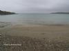
Also depths in channel much less than charted. We draw 1.6 but hit the mud 20m E of lifeboat, where chart suggests 3m + 0.5 of tide. Needless to say we did a quick about turn and anchored in Broadstrand bay.
UPDATE SUMMER 2021
Written by Don Thomson 3 | 25th Aug 2021
I reviewed these notes in August 2021. The phone number for the HM has been removed as neither it nor that posted in the Reeds works. Otherwise no changes
Update Summer 2019
Written by Don Thomson 3 | 15th Jul 2019
These notes were reviewed in July 2019. Thanks to Ningaloo who has just been there there is no need for any changes; I've loaded up this years charts of the bay and replaced the Google link top right
Quiet and scenic
Written by Ningaloo | 5th Jul 2019
On our visit the first 10m of the pontoon was in use by the local fishing charter boats, however we got alongside (ferry gliding against the strong tide) with the help of the charter skipper who took our lines. With 2m draft we also anchored outside for an hour to wait for sufficient rise of tide. Glad we did so. Never less than 3.5m over the bar but only 2.7m on the final loop before the pier.
Still £15 a night. We didn't take electric but this is available by token.
Pay at the pub.
Beautiful quiet spot.
Still £15 a night. We didn't take electric but this is available by token.
Pay at the pub.
Beautiful quiet spot.
Update November 2013
Written by dononshytalk | 25th Nov 2013
Updated 25th November 2013. No changes


© visitMyHarbour.com | website design created by Black Culm Ltd