You are viewing the expanded version of this Harbour,
for faster browsing
use the regular version here

Ore and Alde, Rivers
Courtesy Flag
Flag, Red EnsignWaypoint
Orford Haven Buoy 52:01'.604 N 001:27.'987 E Buoy liable to be moved.Charts
Admiralty 2695, SC5607Rules & Regulations
UnknownHazards
Constantly changing entrance channel, Seas Break, Dangerous in onshore winds, LOCAL KNOWLEDGE ADVISED.Tidal Data Times & Range
Entrance Dover +0015 MHWS 3.2m, MHWN 2.6m, MLWN 1.0m, MLWS 0.4m Orford Quay: Dover +0100 Slaughden Quay: Dover +0155 (links)This site is designed for slower, roaming broadband connections, like you would get at sea, so it needs JavaScript enabled to expand the text.
General Description
The rivers Ore and Alde are actually just one stretch of water that wind their way from Shingle Street to Snape Maltings....
passing by the towns of Orford and Aldeburgh. There are over 15 miles of navigable water, with numerous anchoring opportunities for deep draft craft.
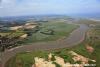
The layout of the River is quite unusual in that it virtually follows the coastline for many miles and in some places there is very little separating it from the sea (see photo gallery).
At one time Orford was a major port but the constant movement of the shingle gradually put it further and further from the sea. Even now the shingle is trying to move further south near the entrance, and there is a tenuous channel through it.
Winter storms shift the banks and the channels dramatically, and the entrance has a deservedly ominous reputation. This doesn't seem to deter the hundreds of people who keep their boats on moorings in the rivers. It does however imply that local knowledge is necessary to enter, and there are the usual gloomy warnings on the charts concerning this matter.
Unlike the entrance to the Deben, there is no handy harbourmaster deployed at the entrance to help guide you in. No charts will display the entrance channel, quite simply because it changes so often.
Surveys are conducted and buoyage is laid from around Easter till October, at which point the buoys are removed.
For those willing to gather all the latest information and make their entry during the right weather and tidal conditions the rewards are great. This article, whilst not being able to give you direct pilotage through the shingle banks will point you in the right directions to obtain all the latest information, including entry chart and aerial photo.
Not pilotage, but this video from Dylan Winter will give you a feel for winter sailing on the Ore
Approach
If approaching from the South, Harwich or the Deben, it is fairly straightforward....
.... to keep a reasonably good offing and locate the red-and-white spherical Orford Haven buoy (LFl.10s). Keep well to seawards of it until ready to commence your approach.
From the North you will be approaching in the Hollesley Bay Channel which has plenty of water and is bounded on it's eastern side by the Whiting Bank. Patches of this dry at CD, and the sea breaks on it, it's best well avoided. It is well charted and buoyed. Locate and identify the Orford Haven buoy (already mentioned) from seawards.
Further pilotage details:
If approaching from the East you can leave the Whiting Bank to the north of you (as marked by the southerly cardinal Buoy SW Whiting (Q(6)+LFl.15s). Approach the Orford Haven buoy from seawards.
On the shore the entrance can be identified by the Martello tower and cluster of houses at Shingle Street.
Before April surveys are carried out and two further buoys are laid, first the red can Oxley buoy (leave to port), and the green conical Weir (leave to starboard). It was noted in this years survey that it may be necessary to move the Weir buoy even further South of its charted position in the near future.
It is not sufficient to simply follow this buoyage, a good study of an up to date pilotage chart (normally produced around April) and an aerial photo taken at low water will be required. Up until 2018 The Orford Sailing Club have produced an annually updated chart of the entrance to the Ore which could be found on the East Coast Pilot website.
www.eastcoastpilot.com/downloads
Quite apart from the intricacies of piloting your way between these knolls and shingle banks the sea state, weather and tides need to be considered carefully.
Any kind of strong onshore winds will cause the whole area to be a mass of breaking seas, and in these conditions entry is impossible... the area should be given a wide berth. In fact heavy weather from any direction makes entrance inadvisable for strangers. The consequences of being set on to a leeward shingle bank and then being pounded should be borne in mind.
Tides run in and out of the narrow entrance channels at alarming rates, up to 4 kn during the flood and 5 kn during the ebb. It is therefore impossible to push your way in against the ebbing tide.
At around low water the extensive shingle banks reveal themselves, so having done some tidal calculations a good time to enter would be about one to two hours after local low water and follow the buoyage in.
Once in the River proper depths increase and it is relatively simple to stay in deepwater. If continuing to move up River remember that the tide will be increasing in strength underneath you propelling you forwards towards Orford.
Berthing, Mooring & Anchoring
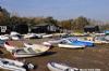
Anchoring is possible anywhere within the River out of the main channel, with holding varying from good mud to dodgy shingle, but be aware that this has become a very popular place especially for yuppies at the weekend. You could be plagued by PWCs, paddleboarders and lots of yoof making lots of noise - on the other hand you may enjoy that atmosphere so, if so, it's just the place for you.
On the Admiralty charts there are lots of Notice Board icons ( ) on the river banks and levees - take heed of them as they are mostly "You can't do that there 'ere" notices. It is also of interest that, at the moment, those NB icons appear as navigation piles on Navionics.
The initial run up Long Reach towards Dove Point is not a good place to anchor. The tides run very hard, the holding is suspect, and there is a waterskiing area. Added to that there are no facilities.
The spit extending from Dove Point is marked by a unlit southerly cardinal buoy, and there are two choices. You can either pass North of Havergate Island, which gives access to Butley River and several other anchorages where a boat can lay in peace, or the more direct southerly route through The Narrows and Main Reach for those intent on reaching Orford and beyond.
Anchorages and moorings in the Rivers Ore and Alde, for yachtsmen and motorboaters:
The anchorages in Butley River and to the north of Havergate Island are best seen on the chart. Even deep draft craft can lay just within the entrance to the Butley River, while shoal draft craft can wiggle their way as far as Gedgrave Cliff. Many oyster layings will be found in the upper reaches, marked by with withies and noticeboards. Avoid anchoring or grounding in these areas.
Havergate Island is a bird sanctuary owned by the RSPB and landing is not allowed here. The little poles with rectangular top-marks scattered around the shores of the Island on Admiralty Charts are notices to this effect and not Navigation Marks as displayed by Navionics .There are several opportunities however to anchor off the north of the island with a particularly sheltered spot being Abrahams Bosum. Anywhere in this area you will be able to find plenty of water together with peace and quiet.... but no facilities.
Whichever way you get around Havergate Island continuing onwards will bring you to the town of Orford, laying on the North bank of the River. From Chantry Point onwards the River is pretty well infested with moorings all the way to Orford and beyond.
Anchorage can only really be had above or below the moorings, and anchorage is not allowed between Chantry Point and Reydon Reach. Some of the moorings are private and others under the control of the Orford Town Trust. Some visitors mooring buoys are maintained on the starboard side of the Channel before you reach the Quay on the port side, but it is generally permissible to pick up a suitable sized vacant mooring buoy. If you are not on a clearly marked visitors buoy you'll need to get in touch with the harbour master as soon as possible. He operates on VHF channel 8 or channel 80 callsign "Chantry", or telephone 01394 459950. Otherwise nip ashore and visit him in his office on the Quay. Orford Quay Warden, Philip Attwood, Mobile: 07528 092635. He has advised us that it would be best to call him to see if there is a spare buoy before coming in the entrance. There is a modest overnight charge. (£10)
When settled either at anchor or on a mooring, dinghy landings can be made at Orford Quay, or the adjacent shingle beach.
The facilities available at Orford will be covered shortly.
Pushing on up River, once past the moorings on either side at Orford the River trends north-east through Raydon Reach. At Pig Pail the River swings northwards and a cable crosses under the River, marked on either side by noticeboards. (There are several cable crossings in the Orford area, again all marked by noticeboards.) On the starboard side you will see the radio masts for the BBC World Service.
At this point the River changes its name to the Alde and continues with the deepwater running fairly centrally up Halfway Reach in a northerly direction, swinging to the north-east in Blackstakes Reach. This is a designated waterskiing area.
Continuing north eastwards a shallower patch, The Horse, straddles the River. It has almost 2 m at CD, so shouldn't be a problem. At this point the River is running parallel with and very close to the beach on your starboard side. In some places there can't be more than 100 yards or so separating the sea and the River.
Now on your starboard side comes the River moorings and quay at Slaughden, the River port of Aldeburgh. There are two active yacht clubs, and the moorings are under the control of Upsons or Cables, the local boatyards. Some visitors moorings are maintained for which there is a modest charge. Alternatively contact either of the boatyards and they may well be able to find you something. Upson's are on 01728 453047 and Cable's are on 01728 452569.
It is not a good idea to anchor anywhere near the moorings as they are packed in tightly and mooring gear is laid across the stream. The recommended anchorage is on the starboard side downstream of the moorings.
The facilities available here and at the town of Aldeburgh are covered shortly.
The River bends round to the West at Slaughden Quay and the next couple of reaches up to Westrow Point have moorings on either side. A cable crosses the River underwater at Westrow Point. The River forms an inverted C shape around Cob Island, and anchorage can be had here in Blackthorne Reach with the Old Brick Dock to starboard. Dinghy landing is possible at the Quay, and it's not far by footpath to Aldeburgh. The channel is marked by withies on the port side.
The intrepid explorer with a shallow draft craft can push onwards as far as Snape Maltings, a trip best and made when the tide is low and rising. The banks will reveal themselves and the channel will be easier to identify. Although it is marked by withies, supposedly with red cans to port and green flags to starboard the newcomer should exercise caution. Having said this quite large and deep vessels reach Snape Maltings, probably aided by local knowledge.
Craft of moderate draft can find anchorages afloat as far as the region of Iken Cliffs, and those willing to take the ground can lay against the Quay at Snape Maltings. The bottom here is soft mud, there are small charges.
Facilities
If moored up anywhere near Orford, landing can be made very centrally. Ashore you will find the Orford sailing Club, on the waterfront very close to the dinghy landing.
Water can be collected in Jerry cans from a tap at the Quay, but the nearest fuel is a good hike away. Boatyard services are available in Orford, but there is no chandlery. For use of the scrubbing posts near the Quay arrange with the harbour master, likewise for use of the slipway. Boats with engines over 8 hp need to arrange an annual license, which is not cheap and PWC's are prohibited. The ramp has access at three quarters of the tidal range.
Day-to-day provisioning can be obtained at the general stores, which although open seven days a week closes Wednesday and Sunday afternoons. It serves as a post office too. A butchers and fishmongers will be found, smoked fish a speciality. There are no banks.
Public transport is not good, with only a few buses a day going to Woodbridge and Ipswich (for good onward transport links).
If near Aldeburgh you will find a larger range of facilities. Water is available at the yacht club and on the Quay. Diesel is available from Upson's yard, with petrol available in the town. There is a chandlery at Aldeburgh Boatyard, and bottled gas can be obtained.
Trailer Boats can launch from Upson's Boatyard with access at half the tidal range. Charges are between £5 and £10 but you will need to check in advance in case the slipway is blocked by other work. (01728 453047).
Full boatyard services are available in the area, while the two yacht clubs Aldeburgh Yacht Club and Slaughden Sailing Club are said to welcome bona fide visiting yachtsman.
The town which lies slightly to the North of Slaughden Quay, offers a good and useful selection of shops including a Co-Op. Banks and cash machines will also be found much to the relief of those running short.
Bus services from here connecting with Saxmundham, Woodbridge and Ipswich run regularly and all three destinations have stations.
All in all most boating needs can be met within the Ore and Alde.
History
Orford
Orford is a small town in Suffolk, England, within the Suffolk Coast and Heaths AONB.
Like many Suffolk coastal towns it was of some importance as a port and fishing village in the Middle Ages. It still has a fine mediaeval castle, built to dominate the River Ore.
The main geographical feature is Orford Ness, a long, wide spit at the mouth of the Ore. Orford Ness has variously been used as an airstrip testing facility and nature sanctuary over the years. It is reached by ferry from Orford's quay.
In the early 1970s Orford Ness was the site of a very powerful radar station as part of the Cold War defences against low flying attacking aircraft.
Orford now mainly exists on tourism and as a weekend and holiday home. It has grown significantly in the last 20 years with an increasing new build to accommodate second home-owners; its population greatly increases during the summer months due to its flourishing sailing club. As well as the Castle, Orford's attractions include river cruises, a number of pubs and hotels, a traditional post office which sells fresh bread, a smokehouse, and two restaurants; the Butley-Orford Oysterage and the Crown and Castle Hotel, owned by food writer Ruth Watson.
Aldeburgh
Aldeburgh is a picturesque coastal town in Suffolk, East Anglia, England. It is noted for the internationally renowned Aldeburgh Festival of arts, which takes place at nearby Snape Maltings. The festival was created in 1948 by the resident and acclaimed composer Benjamin Britten.
A popular weekend destination, particular attractions are the ancient Moot Hall (where the town council still meets today), Napoleonic-era Martello tower to the south, sheltered yachting marina at Slaughden, and two family run shops serving Fish and Chips, one of which is often cited as among the best fish and chip shops in the UK.
History
Alde Burgh means "old fort" although this structure, along with much of the Tudor town, has now been lost to the sea. In the 16th century, Aldeburgh was a leading port, and had a flourishing ship-building industry. Sir Francis Drake's ships Greyhound and Pelican (later renamed Golden Hind) were both built in Aldeburgh. The flag ship of the Virginia Company, the Sea Venture is believed to have been built there in 1608. When the River Alde silted up and was unable to accommodate larger ships, the area went into decline. Aldeburgh survived principally as a fishing village until the nineteenth century, when it became popular as a seaside resort. Much of its distinctive and whimsical architecture derives from this period. The river is now home to a flourishing yacht club.
Geography
The town is within the Suffolk Coast and Heaths AONB. The beach at was awarded the Blue flag rural beach award in 2005. Just south of the beach at Aldeburgh is Orford Ness, which can be reached by a track leading from Aldeburgh, which is popular with people sea fishing.
Transport
Aldeburgh railway station opened in 1860 as a branch from Saxmundham. The station was closed in 1966 as part of the Beeching Axe.
The Moot Hall
The Aldeburgh Moot Hall is a timber-framed building which has been used for council meetings for over 400 years. The Town Clerk's office is still there and it also houses the local museum. It was built in 1650, although there was some restoration in 1854 when chimneys copied from Hampton Court were added.
Aldeburgh has a unique quatrefoil Martello Tower.
The Scallop
On Aldeburgh's beach, a short distance north of the town centre, stands a sculpture, The Scallop, dedicated to Benjamin Britten, who used to walk along the beach in the afternoons. Created from stainless steel by Suffolk-based artist Maggi Hambling, it stands four metres high, and was unveiled in November 2003. The piece is made up of two interlocking scallop shells, each broken, the upright shell being pierced with the words: "I hear those voices that will not be drowned", which are taken from Britten's opera Peter Grimes. The sculpture is meant to be enjoyed both visually and tactilely, and people are encouraged to sit on it and watch the sea.
The sculpture is controversial in the local area. Many people consider that it is inappropriate for a man-made object to spoil a beautiful natural setting. It has been attacked with graffiti and paint on a number of occasions, and there have been petitions to have it removed.
Notable people
The poet George Crabbe was born in Aldeburgh in 1754 and the town forms a loose basis for his poems The Village' and The Borough. He also wrote a poem about an Aldeburgh fisherman Peter Grimes, on which Benjamin Britten's opera was based.
Benjamin Britten became a resident of the town in 1942. In 1948, along with Eric Crozier and Peter Pears, he founded the Aldeburgh Festival. Britten died in Aldeburgh in 1976. Pears, a noted tenor and Britten's life-long partner, also died in Aldeburgh in 1986. They are buried alongside each other in the churchyard of St Peter and St Paul's Church in the town.
Culture
Outside the town, the Snape Maltings is the venue for the Aldeburgh Festival held every June.
The town of Aldeburgh or "Owlbarrow" is the setting of a series of children's illustrated books centred on Orlando (The Marmalade Cat) written by Kathleen Hale, who spent holidays in the town. Many of the illustrations in the books feature landmarks in the town, most notably the Moot Hall.
Aldeburgh is also notable for it's fish and chip shop. Owned and run by the Cooney family since the 1970s, it has been described in The Times as "possibly the finest on the East Coast".
The Suffolk Craft Society hold an annual themed exhibition in the Peter Pears Gallery over July and August. This is the annual showcase for the finest and most recent work made by members.
The text on this HISTORY page is covered by the following licence
http://en.wikipedia.org/wiki/Wikipedia:Text_of_the_GNU_Free_Documentation_License
Eating, Drinking & Entertainment
Orford is a bit off the beaten track but still offers a good choice of eating and drinking establishments for the passing sailor, starting right with the shingle beach where you land in the dinghy. Here you will find tearooms, where you can sit outside and survey the nautical scenes in the River.
Pushing further into the town you will come to the Jolly Sailor Pub which opens up at lunchtimes and in the evenings, serving food.
The King's Head is also open lunchtimes and evenings, serving food too.
Restaurants include the Butley Orford Oysterage Restaurant, tending to specialise in seafood and fish, open lunchtimes and evenings. The Crown and Castle Hotel is run by a cookery writer and their Trinity Restaurant has been awarded the Michelin Bib Gourmand.
In all eating establishments in this part of the world you may find things run a little early, especially if you're used to continental mealtimes. Arriving early or booking in advance may be advisable.
If moored up near Aldeburgh you will find a much wider choice of establishments ranging from fish and chips upwards. In fact one of the fish and chip shops has an enviable reputation as serving " possibly the best fish and chips on the East Coast" according to The Times.
In the town there is a much larger choice including pub meals, a Chinese takeaway and an Indian restaurant amongst others...
Further investigations may be helped by the links below:
Pubs:
http://www.beerintheevening.com/pubs/results.shtml?l=aldeburgh
Eating Places
Links
|

Your Ratings & Comments
Keep up the good work on this excellent website.
Colin. Www.solocoastalsailing.co.uk
http://www.eastcoastpilot.com/downloads.html