

Harbour Information (use the  icons to find out more)


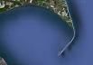
Spurn Head Anchorage (including Approaches to the River Humber)
Your Comments: 20 Read or add your comments
Courtesy Flag
Flag, Red EnsignWaypoint
Approach to Spurn Head Anchorage 53:34'.585 N 000:06'.2 ECharts
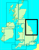
Admiralty, 1188Rules & Regulations
See Full Bye Laws. www.humber.comHazards
Fierce Tides and Shipping amongst others.Tidal Data Times & Range
Hull -0050 (Approx) MHWS 6.9m, MHWN 5.5m, MLWN 2.7m, MLWS 1.2m (links)This site is designed for slower, roaming broadband connections, like you would get at sea, so it needs JavaScript enabled to expand the text.
General Description
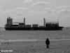
Spurn Head is the promontory guarding the mouth of the River Humber. ... read more
Approach
Any kind of approach to the River Humber needs a good study of the charts...... ... read more
Berthing, Mooring & Anchoring
Once safely past Spurn Head you will see various moorings and the jetty..... ... read more
Your Ratings & Comments
20 comments
Update June 2022
Written by Don Thomson 3 | 15th Jun 2022
I reviewed these notes in June 2022. No changes apart from the fact that Spurn Head is now cut off from the mainland at High water.
1 of 1 people found this helpful
Spit now washed over!
Written by Simon Howarth | 27th Jul 2021
The Spurn spit is no longer connected to the "main land" by road. The spit is now washed over at high water and is gradually becoming an island.
The RNLI still maintain their only permanently manned lifeboat at Spurn and it is moored close to the yacht anchorage, perhaps a comfort for some.
The pilot boats still use the jetty from time to time and the "yacht buoy" is still available, those who moor to it say use a long warp to avoid bumping as the tide turns.
SANUTI
CR579
3 of 3 people found this helpful
UPDATE SPRING 2021
Written by Don Thomson 3 | 10th May 2021
No changes
1 of 1 people found this helpful
Update Spring 2019
Written by Don Thomson 3 | 23rd Apr 2019
I reviewed these notes in April 2019. I've added the Humber VTS telephone number and replaced the charts. I've also checked that there is still a small yacht buoy there.
4 of 4 people found this helpful
UP DATE MARCH 2017
Written by Don Thomson | 31st Mar 2017
These notes were reviewed by Don in March 2017. have added up-to-date charts but no other changes
TETNEY MONOBUOY.
Written by mudpilot | 18th Sep 2015
For the perfectionists. Following replacement of the Tetney Pipe Line the updated Monobuoy Posn.
53 32.364N 00 06.760E. (source Humber.Com)
53 32.364N 00 06.760E. (source Humber.Com)
Update 2015
Written by dononshytalk | 12th Mar 2015
These notes were reviewed and updated by Don in March 2015.
HUMBER ANCHORAGES
Written by mudpilot | 25th Dec 2013
Hawkins Point.
If wind from the NW to NE you may prefer to anchor close in to Hawkins Point for a quieter anchorage than off the Spurn Pilot Jetty.
If you require the flood to go up River. Bestt leave this location LW Immingham + 1 hour. The ebb runs for about 45 mins. after "book" LW Immingham.
If wind from the NW to NE you may prefer to anchor close in to Hawkins Point for a quieter anchorage than off the Spurn Pilot Jetty.
If you require the flood to go up River. Bestt leave this location LW Immingham + 1 hour. The ebb runs for about 45 mins. after "book" LW Immingham.
1 of 1 people found this helpful
WHITTONS ANCHORAGE
Written by mudpilot | 22nd Jul 2013
Regarding the anchorage used by a few local boats inside Whitton Island, between Brough and Market Weighton Locks. On spring spring tides a bore tide can occur. I've experienced such when the tidal range at Blacktoft is in the region of 6.0m. The height of the incoming tide is not as per the larger one experienced on the Trent. But the speed and sound of it's approach can be impressive. Best ensure you're anchor gear's reliable if intending to anchor in this area. I've gone from sat on the mud heading in to afloat heading out and gear at full stretch in seconds.
TETNEY MOORING BUOY
Written by mudpilot | 26th Apr 2013
For info. There's a 500m exclusion zone around the SBM.
Oil tankers discharging on the SBM will be in the region of 245m loa. With a tug made fast aft throughout his stay. The tug and his towing gear stretched will be another 50m+.
Oil tankers discharging on the SBM will be in the region of 245m loa. With a tug made fast aft throughout his stay. The tug and his towing gear stretched will be another 50m+.
TRENT ANCHORAGE.
Written by mudpilot | 24th Apr 2013
The original anchorage to the west of Island Sand is once again to be used by leasure craft. The previous anchorage to the North of West Walker Dyke is prohibited. Source www. Humber.com.
Rgds.
Rgds.
SPURN ANCHORAGE.
Written by mudpilot | 24th Apr 2013
With SW'lys it can be a very uncomfortable anchorage. Wind against tide along with the wash from commercial vessels using the Sunk Dredged Channel, especialy at "ferry times" will not afford a good night's sleep.
As an alternative I'd consider anchoring SW of the Bull Anchorage. Lincolnshire affords some shelter from SW'lys. However the fast craft working out of Grimsby to the wind farms still supply the wash effect for you. Regards.
As an alternative I'd consider anchoring SW of the Bull Anchorage. Lincolnshire affords some shelter from SW'lys. However the fast craft working out of Grimsby to the wind farms still supply the wash effect for you. Regards.
Update 2013
Written by dononshytalk | 10th Apr 2013
These notes were reviewed by Don T on the 10th April 2013. The position of the Tetney Monobuoy has been corrected for now but can be expected to move again (remember guys that this buoy is moored in a tidal estuary in nearly 50 ft of water with a blooming great hose attached and we are not using it to calibrate our electronics!!). I've corrected our Waypoint to indicate that it is an entry point, not an anchoring position; as is mentioned below, if you anchor there you'll be way too deep and close to the shipping lanes. Shame about the Cafe!!
1 of 1 people found this helpful
SPURN CAFE
Written by mudpilot | 2nd Jan 2013
Please note the RNLI crew are no longer resident at Spurn, apart from the Duty Crew. I believe that it was a RNLI wife that ran the cafe so would not assume it's still operating even in the holiday seasons now..
SPURN HEAD ANCHORAGE
Written by mudpilot | 2nd Jan 2013
Please note the quoted waypoint is not the anchorage? You are in close proximity to the pilot launch tracks.
Large or fast vessels using the Sunk Dredged Channel could also pose a problem with their wash as they round the Point close in. You are also very close to the 10m contour at the quoted waypoint.
Have anchored N53 34 740 E00 06.100 to the north of the Sunk Dredged Channel buoy line well clear of shipping 3.0m CD.
Humber VTS Ch.14 best contacted prior anchoring for confirmation that you're clear of the SDC approaches.
TRENT ANCHORAGE.
Written by mudpilot | 2nd Jan 2013
The original anchorage for pleasure craft bound to and from the Trent is now prohibited. Original anchorage was past the Apex inbound and to the west of Island Sand. This area to the west of Island Sand was used by commercial shipping earlier this year and although the channel has now shifted to the east this anchorage remains prohibited to leasure craft. www. Humber.com (Upper Humber Bi. Monthly charts apply)
The current recommended anchorage for leasure craft is now abt. 2.5 cables north of West Walker Dyke Lt., clear of the commercial shipping lanes. 0.5m CD
(I have also anchored to the North of Whitton Island also well clear of commercial vessels.)
The current recommended anchorage for leasure craft is now abt. 2.5 cables north of West Walker Dyke Lt., clear of the commercial shipping lanes. 0.5m CD
(I have also anchored to the North of Whitton Island also well clear of commercial vessels.)
TETNEY MONOBUOY
Written by mudpilot | 2nd Jan 2013
The Monobuoy Posn, source www. Humber.com
TETNEY MONO MOORING 53 32.364 N 00 06.760 E
TETNEY MONO MOORING 53 32.364 N 00 06.760 E
Tetney Mono Buoy location
Written by StephenM | 1st Jan 2013
The article on Spurn Head has incorrect coordinates for the Tetney Mono Buoy
it should be:
LATITUDE = 53 32.349N
LONGITUDE = 00 06.770E
it should be:
LATITUDE = 53 32.349N
LONGITUDE = 00 06.770E
1 of 2 people found this helpful
SPURN POINT ANCHORAGE
Written by mudpilot | 10th Jun 2012
The Humber Pilot Launches operate from this jetty. Anchoring too close to the Pilot Jetty will provide you with a noisy and restless anchorage if it's a busy tide.
1 of 1 people found this helpful
Spurn Eating
Written by RedFox226 | 2nd Apr 2012
Sadly, the last 2 occasions I visited, the Spurn cafe appeared to be closed down (2011)
2 of 2 people found this helpful
© visitMyHarbour.com | website design created by Black Culm Ltd