

Harbour Information (use the  icons to find out more)

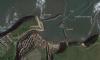
Staithes
Your Comments: 3 Read or add your comments
Courtesy Flag
Flag, Red EnsignWaypoint
54° 33.9N 000° 46.8WCharts
UKHO 0134, Imray C27Rules & Regulations
Speed Limit 5 knots Maximum leisure boat length 8 metresHazards
Rock shelf projecting out from the cliffs to quarter of a mile off shore and bordering the approachTidal Data Times & Range
HW Staithes is approx. Dover + 5.00 or R.Tees + 20min Range about 4 metresThis site is designed for slower, roaming broadband connections, like you would get at sea, so it needs JavaScript enabled to expand the text.
Approach
Staithes is a tidal harbour; the CD line is approximately at the harbour entrance and rises to about CD +4.6m at the beach... ... read more
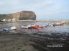
Berthing, Mooring & Anchoring
They have put in rings and ladders for the use of visiting boats at the root of the East Pier.... ... read more
Your Ratings & Comments
3 comments
Update June 2022
Written by Don Thomson 3 | 15th Jun 2022
No changes
UPDATE SPRING 2021
Written by Don Thomson 3 | 10th May 2021
I reviewed these notes in May 2021. We have altered the text to include warnings about the East wall in Northerly winds.(Thanks to Jes below)
Possibility of swell in the harbour
Written by Jes | 7th Aug 2020
I received a friendly welcome and found room to moor along the wall in between fishing boats. I dried out nice and level onto firm sand. I was told to leave the next day because the forecast strong W wind would cause a NW swell and make being tied up to the wall dangerous. All the fishing boats moved to moorings in the middle of the harbour.

© visitMyHarbour.com | website design created by Black Culm Ltd