You are viewing the expanded version of this Marina,
for faster browsing
use the regular version here

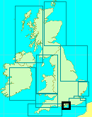
Southampton Water, including approach to Hamble River and Hythe Marina Village
Courtesy Flag
Flag, Red EnsignWaypoint
From E East Bramble(E.Cardinal) 50:47'.23N 001:13'.63W From W Lepe Spit (S.Cardinal) 50:46'.78N 001:20'.64WCharts
Admiralty 2036, 2041, 2038, SC5600Rules & Regulations
Moving Prohibited Zone around shipping, see text for details.Hazards
Shipping, Bramble BankTidal Data Times & Range
Double HW, First HW approx -0013 Dover (Springs) Stand halfway up flood tide. MHWS 4.5m MHWN 3.7m MLWN 1.8m MLWS 0.5m (links)This site is designed for slower, roaming broadband connections, like you would get at sea, so it needs JavaScript enabled to expand the text.
General Description
Southampton Water is the deep water inlet leading 6 miles from the Solent to the historic city of Southampton, with its deep water docks and jetties.
Many of the navigators in this area will have become used to the tall chimney on Calshot Spit giving a reassuring idea of where one is. Be Advised, the Calshot Chimney has been demolished.
The area benefits from double high waters or a long stand of the tide, and that together with the fact that it is relatively easy to keep dredged has enabled the port to continue to attract large volumes of heavy shipping. This section deals with approach and entry from the Solent, entering the River Hamble from Southampton Water, and finally the approaches to the Docks, and the River Itchen.
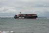
Getting into Southampton Water from the Solent is complicated by the very inconvenient Bramble bank more or less right in the way. This means that the very heavy deep draft shipping approaching or leaving this area have to execute a complicated lumbering turn virtually mid Solent, with very little room to play with. Adding to the excitement are the Red Funnel car ferries and fast cats constantly plying between Southampton and Cowes.
The approaches from the East and West are dealt with shortly, but once within Southampton Water itself it is not necessary to use the shipping channel. Adequate water exists outside the channel but crossing from one side to the other can be nerve racking at times.
There is nothing to stop you anchoring in Southampton water as long as you are away from prohibited areas, and moorings etc. but... the sheer size of the place makes this option untenable except in the most settled conditions. This is not generally considered a cruising area in its own right but small high-speed craft seem to have much fun in the sheltered waters. The scenery for much part is industrial with exceptions.
Approach
The yachtsman or motorboater needs to exercise extreme care in the approaches to Southampton water.
A quick glance at the photo gallery will show you the size of the shipping you are going to encounter in the approaches. The net result of all this to small craft skippers is that extreme care is needed in this area and a good study of the advice and regulations promulgated below by the Southampton Harbour Authorities is essential.
A thorough understanding of these, coupled with the pilotage information we now provide will hopefully keep you out of the way of shipping and ferries, and get you up to the docks area.
Deep draft shipping approaches Southampton from the eastern Solent and then has to make almost 90° turn to the North then the North East finally swinging to the North and then Northwest in the region of Calshot Spit. They have no room to play with and furthermore if they put their engines astern they can lose steerage as there is no propwash effect and even then it could take more than a mile to stop them.
The following extract is from Southampton VTS:
"Collision Avoidance Checklist
• Avoid commercial ship channels if at all possible and especially in poor visibility
• Cross shipping channels quickly and at right angles to the channel
• Be alert and watch for ship traffic
• Be seen, especially at night
• Know whistle signals - five or more mean DANGER
• Listen to VHF Channel 12 – the Port of Southampton working frequency
• When transmitting a message, keep it brief, say what you have to say, then remain listening
• Use up-to-date charts - read Local Notices to Mariners at your club or local marina.
• Keep in mind that FEW SURVIVE collision with ships
• When in doubt, keep clear
• Always be prepared for the unexpected; life jackets do not help if you are not wearing them
• Be aware of the Precautionary Area (Thorn Channel) and the Moving Prohibited Zone as defined in Notice to Mariners No. 33/2003 – see below
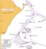
Area of Concern – Notice to Mariners No. 33/2003
Port of Southampton – Precautionary Area (Thorn Channel)
Credit: Port of Southampton
Area of Concern
1 Notice Is Hereby Given that all vessels navigating within the Port of Southampton shall ensure that a vessel greater than 220m shall be given a 'clear channel' between Hook Buoy and the Prince Consort Buoy (Precautionary Area).
The term 'clear channel' is defined as:
'A clear channel vessel is one which requires a clear and unimpeded passage ahead when transiting the Precautionary Area'.
Vessels may enter the Precautionary Area (see chartlet) maintaining a safe distance astern of a 'clear channel' vessel.
2 Two vessels each having a length greater than 180 metres shall not pass or overtake each other between Hook Buoy and the Prince Consort Buoy.
3 Moving Prohibited Zone (MPZ)
The Southampton Harbour Byelaws 2003 (No 11) enforces the requirement that all vessels over 150 metres in length when navigating within the Precautionary Area referred to in this notice are automatically allocated a Moving Prohibited Zone (MPZ). The MPZ is an area extending 1000 metres ahead and 100 metres either side of any vessel greater than 150 metres within the Precautionary Area.
The master of a small vessel (less than 20 metres in length or a sailing vessel) shall ensure that his vessel does not enter a Moving Prohibited Zone.
For the purpose of indicating the presence of the Moving Prohibited Zone the master of any vessel of over 150 metres length overall shall display on the vessel, where it can best be seen, by day: a black cylinder, and by night: 3 all round red lights in a vertical line.
When operationally possible the Southampton Harbour patrol launch (VHF Call Sign ''SP'' Channel 12) will precede these vessels within the 'Precautionary Area' showing, in addition to the normal steaming lights a blue fixed light. The absence of the patrol launch will not invalidate the implementation of the moving prohibited zone."
Traffic Information Broadcasts
By Southampton VTS on VHF 12, for small craft, every even hour, 0600 to 2200 LT, Friday to Sunday and Bank Holiday Mondays from Easter to 30 September.
A link to their website is provided for further study:
http://www.southamptonvts.co.uk/yguide.htm
To download a PDF document that provides much useful guidance from Southampton VTS a link is provided below:
http://www.southamptonvts.co.uk/admin/content/files/PDF_Downloads/Yachtsmans-guide-LowRes.pdf
Pilotage Notes..approach and entry to Southampton Water, entry to the Hamble River, and passage up to the River Itchen.
For the small craft navigator approaching from the East most of this complicated dancing around can be avoided by using the North channel shown clearly on our Central Solent chart. It is well buoyed and has least depths of around 3 m, and it first involves locating and identifying the easterly Cardinal buoy East Bramble (VQ(3)5s). This is left on the port hand side and continuing on a generally north-westerly course will bring you to the red can buoy Hill Head (Fl.R.2.5s). This is also left to port and continuing Northwest you will approach the northerly Cardinal buoy Bell Calshot (VQ). A more northerly course now will keep you out of the channel leaving this buoy well off on your port side. Deepwater is available on your starboard side as far as and beyond the yellow seasonal spherical buoys that run parallel with the main channel. Follow this buoyage in a generally north-westerly direction again. Do not be confused by a further line of yellow buoys closer into the shore, although even these have around 1 m at CD.
Continuing on will bring you to the green conical Bald Head buoy (Fl.G.2.5s) which must be left on your starboard side and then the South Cardinal buoy Hamble Point (Q(6)+LFl.15s) which again can be left well to starboard, unless planning to enter the River Hamble. Much small craft traffic can be expected in this area during the season. From here aiming for the BP Hamble terminal and leaving any yellow spherical buoys to starboard will keep you in deep water. On the opposite Western side you will see the Fawley Marine Terminal and it's associated shipping. Having passed the BP terminal at a safe distance and continuing in a generally north-westerly direction lookout for the green conical Greenland buoy (IQ.G.10s) and keeping outside of the main channel altogether leave this on your port side. By now you should see the run of the main channel clearly with its red and green buoyage, and it is simply a matter of running parallel to it.
Approaching from the West involves getting more mixed up with the shipping however you go about it. From the Lepe Spit southerly Cardinal buoy (Q(6)+LFl.15s) it is possible to keep out of the channel by leaving the North East Gurnard red can buoy (Fl(3)R.10s) on your starboard side, and continuing in a generally north-easterly direction leaving the Bourne Gap red can buoy (Fl.R.3s) to starboard also. If planning to enter the Hamble River or generally making your way to Southampton this may be a good opportunity to cross the shipping channel in an area where it is narrow, as there is far more water to play with on the eastern side now. A recommended crossing point is after passing North East Gurnard buoy and before reaching Bourne Gap buoy, in the region of the green conical buoy Thorn Knoll (Fl.G.5s). If it is safe to do so cross at 90° and continue your course north-eastwards, leaving the green buoy North Thorn (Q.G) on your port side and the northerly Cardinal buoy Bell Calshot (V.Q) to port too. The yellow spherical buoy should be made for, a north-westerly course set and instructions already given about approaching from the East can be followed. When planning to cross at 90° bear in mind that although deep draught ships will only be found in this channel, the Red Funnel car ferries and fast catamarans may well be operating in the relatively shallow areas outside of the main channel.
If unable to cross and continuing your approach using the Western side of the Channel be aware that there is less water to play with on your port side, and close attention to depth is now needed.
Calshot Spit (Fl.5s6M) is a substantial red catamaran type structure and again is left on your starboard side as is the red can buoy Castle Point (IQ.R.10s), and this particular buoy needs to be passed fairly closely to avoid shallows on your port side. A generally north-westerly course will bring you to the Black Jack red can buoy (Fl(2)R.4s) which also needs to be left very close on the starboard side to avoid the shallows to port.
Leave Black Jack buoy close to starboard and pass Calshot Castle and make for the Fawley Terminal, keeping close to the Western edge of the available water as marked by the posts with the red top marks and lights. Look for your opportunity to cross safely before you reach the terminal. Once on the eastern side there is more water to play with out of the channel, and instructions already given can be followed.
A listening watch should be kept on VHF channel 12, and this channel can be used to call ships (working on channel 6 or other inter ship channels) if you are unsure of their intentions. Whatever their nationality they will have an English speaking pilot on board.
If planning to enter the River Hamble, approach is made from the southerly Cardinal buoy Hamble Point (Q(6)+LFl.15s) and a northerly course from here will take you between a lit green post (Q.G.2M) and an easterly Cardinal Mark on a post (Q(3)10s2M). At night the white sector of the sectored light (Dir Oc(2)WRG5m4M) on the shore will help guide you. Further instructions for the Hamble will be in a separate article...
In general the sheer amount of shipping and activity in the approaches will need much concentration and can be a little nerve wracking, however once past the oil terminals and safely out of the channel on the eastern side things become more relaxing.
Berthing, Mooring & Anchoring
The main berthing facility in the area covered is Hythe Marina Village lying on the port hand side in the close approaches to Southampton docks , clearly shown in the aerial pictures. Full details of berthing arrangements and prices here are covered shortly. If a visitors berth can't be arranged here, there are plenty of other options in the River Itchen, covered separately.
There is also a quiet little alternative up Ashlett Creek just a bit up from Calshot Spit
This is a small, drying creek on the west side of Southampton Water, leading to an attractive natural drying harbour with a friendly yacht club.
The creek is entered at a PHM post, immediately south of the Esso jetty and well-marked with P & S buoys. The channel is shallow at the best of times and dries completely at about half tide. It tends to shift each winter and the buoys are said to be moved each spring to accommodate this. The description in the almanac is therefore always out of date, but the buoys will see you right. The last SHM should be approached closely before turning to port to enter the drying moorings at the top of the creek, or more sharply to port to tie up alongside the drying pontoon which is supplied with both water and electricity.
The Club has a web site with further details of the navigation in and you can find that site here:-
Ashlett Sailing Club
There's a basic toilet/shower block accessed by a code, and a friendly clubhouse which has been known to provide tea but can probably do more than this at various times.
Walks to Calshot and elsewhere, and when the tide and club members go away there's nobody within half a mile - apart from the pub at the top of the harbour.
Despite the proximity of the oil industry it's a secluded and pleasant harbour.
We are informed of another little Creek just behind Calshot spit (which is occupied by a Leisure Activities organisation. Our member, Tyro Sailor, has left notes in the "Have your say" section at the bottom of this article which explain the situation there but it sounds that, although sheltered, it may prove awkward getting to and fro to the shore at LW. We can see an extensive Boat Club park on the shore but those with masts appear to be mainly trailer sailers with drop keels - ie very small draught.
The Hythe Marina complex lies on the Western side of Southampton water opposite the entrance to the River Itchen and is approached by its own dredged channel and lock with 2.5 m being maintained within the basin. The lock works 24 hours a day throughout the year and visitors are welcome if there is space. The outer marks to the channel which is dredged to 1.5 m LAT consist of an easterly Cardinal beacon (lit) and a post with red rectangular top Mark (lit).
Beware - there's a new PHM (Test R Fl(2)R4s) on the main channel opposite the end of Hythe pier
Call Hythe Marina Village on VHF channel 80 or telephone 023 8020 7073 to check availability of berths before entering the channel and in all cases before transiting the lock. The lock may remain open around high water for a free flow period, and traffic signals are exhibited at the control tower. Three fixed red lights mean wait, three flashing red lights mean all traffic stop, three fixed green lights mean go ahead, and two fixed green lights over one fixed white light when the lock is open for free flow. Permission must be obtained before transiting the lock when it is open for free flow.
There is a handy waiting pontoon just outside the lock. The lock itself has hanging warps for you to grasp whilst in the lock so you just need fenders. Watch out for cross tides and winds in the approach.
 Charges (2022) in this Marina workout at £4.40 per metre for boats under 12.5 m rising to £5.60 per metre for boats up to 18m. Short stays of less than four hours are charged at £10.45 for boats below 15m and £15.40 for those above that. Link to website below:
http://www.mdlmarinas.co.uk/mdl-hythe-marina-village/
Updated January 2022
Further Berthing Information
"Half way up Southampton Water, on the eastern shore, lies Netley Abbey and the country park. It is possible to anchor just north of the Netley Sailing Club and go ashore in the dinghy. It can get a bit rolly with the ferries and shipping plying up and down but there are some enjoyable walks, a miniature steam railway, and a cafe in the park. We also anchor here to visit the Boat Jumble, unfortunately you still have to pay to gain entry...
Guide price : Free"
This information is reproduced here by kind permission of Alan Holmes, his site below has much information about Solent harbours and anchorages, has some good photos, and is based on plenty of hands on experience...check it out
Facilities
For the boat and crew the Marina offers all the usual facilities including petrol and diesel, Calor gas, water and electricity on the pontoons, WiFi and a laundry ashore.
Shoreside toilet facilities must be used, as toilet pumping is strictly forbidden in this enclosed area of water. For those with holding tanks sewage pump out facilities are available.
A 40 tonne travel left, and a hardstanding area together with a small chandlery complete the picture here.
There is a convenience store in the Marina village, and not too far a hike away is Hythe Village. A supermarket and post office will be found here, together with a bus service to Southampton and elsewhere. Small ferries run from the end of Hythe pier to Southampton Town Quay. A few years ago the pier was sycthed through by a small coaster in the charge of a drunken skipper....
History
Southampton Water is a stretch of the sea north of the Isle of Wight and the Solent, in England. The city of Southampton lies at its most northerly point. Along its saltmarsh-fringed western shores lie the New Forest villages of Hythe and "the waterside", Dibden Bay, and the Esso oil refinery at Fawley. On the slightly steeper eastern shore are the Southampton suburb of Weston, the villages of Netley and Hamble-le-Rice, and the Royal Victoria Country Park.
Together with the Solent, Southampton Water is world-renowned for yachting.
Geographically, Southampton Water is classified as a ria, or drowned valley, of the English Channel. It was formed by the rivers Test, Itchen and Hamble which flow in to it, and became an inlet of the sea at the end of the last ice age when sea levels rose, flooding many valleys in the south of England.
Southampton's emergence as a major port, and particularly as a port handling very large vessels, depended partly on certain geographical features of Southampton Water. Its depth, even in its undeveloped state, was generous; this depth of water has been increased over the years with comparative ease since the soft silt of the river-bed allows for easy dredging. An additional factor is the phenomenon of the "double tide", which results in unusually prolonged periods of high water. This greatly facilitates the movements of very large ships.
Southampton Water is an estuary with major potential for land use conflicts. An area of urban development (the Waterside) runs in the narrow band of land between Southampton Water and the New Forest National Park. Villages such as Marchwood, Hythe, Dibden Purlieu, Holbury and Fawley have all experienced significant growth.
Dibden Bay
Between Hythe and Marchwood, an area of undeveloped land - Dibden Bay - was the site of a proposed port expansion by Associated British ports. This was argued to be essential for the continued economic development of the Port of Southampton but the development was vigorously opposed by conservation groups. The intertidal marshlands of Dibden Bay have international significance (Ramsar status).
The planning enquiry eventually rejected the application from Associated British Ports recommending that the environmental value of the site could not be over-ruled when there were alternative sites for port expansion in southern England which had not yet been fully explored. The government accepted the recommendations of the planning inspector in April 2005.
Hythe Pier Incident in 2003
In the evening of November 1, 2003 the dredger Donald Redford collided with the pier, tearing a 150 foot (45 m) hole through the pier's mid-section and completely isolating the pier head from the land. Fortunately the dredger missed the pier train, and there were no human casualties, although a few minutes before the pier was crowded as people were heading home after a football match. Repairs to the pier were carried out by Dudley Barnes Marine with Beckett Rankine as the designer; the cost was £308,000 and the pier reopened on January 7, 2004.
The master of the dredger was subsequently sentenced to eight months in prison after pleading guilty to an act likely to cause the death of or serious injury to any person while under the influence of drink and causing damage to a structure while under the influence of drinking.
The text on this HISTORY page is covered by the following licence
http://en.wikipedia.org/wiki/Wikipedia:Text_of_the_GNU_Free_Documentation_License
Eating, Drinking & Entertainment
On-site at the Marina are a pub and a restaurant. Hythe village offers further choices with various pub restaurants and an Indian.
The Marina could make a good base for exploring the New Forest inland, or shopaholics are only a ferry ride away from the huge shopping centre at West Quay, Southampton.
Links
Mr. Nicholas Hill covers this area online too.........good photos !
www.channelpilot.info/soton.php
|

Your Ratings & Comments
Approach (under power, since there's no room inside to get the sails down) not long before high water from the south-west and head for the two white buildings. The right hand one is the Clubhouse and the one on the left is the nature reserve welcome centre. Leave the yellow pole with the cross to port and head for the black one with white bands. Leave this close to starboard and turn slowly towards the well-marked harbour entrance, with a close eye on the echosounder. There's a gravel bank in the way if you turn too sharply, but you should be OK near the top of the tide.
In the entrance keep well to starboard to avoid the obvious shingle bank on the port side. The plastic jigsaw pontoon (well-fendered, so you don't need yours) is directly ahead. There are no cleats but plenty of rings to tie to. The harbour is open to the south-east but otherwise well-sheltered.
If no-one's around from the club (worth a call beforehand) call the helpful and friendly harbourmaster (number in the almanac) for advice on getting ashore - you'll need the combination for the dinghy-park gate lock....or use your dinghy. The bottom is gravel and mud, and the (three!) slips are available for drying out. The River Meon discharges through the harbour so it doesn't dry completely.
Enter the creek between the blue tugs and the nearest PHM, the one with the topmark. Straight from there to the buoyed channel. The shallowest bit is between the second and third pairs of buoys. After that, turn to starboard and follow the beacons. The last SHM mentioned in the text is no longer there.
I have photos of the channel if someone can upload them.
I read that the site of the power station will be used to build a development of luxury houses. And I assume that the adjacent Power Station Creek (see below) is no longer available to yotties.
A sad, but inevitable loss.
Dinghy ashore above half-tide; below that the landings are VERY muddy (he said, from bitter experience). The pontoon looks inviting but is private, usable only close to HW and has a locked gate. The slip to its right is a better bet, as long as you're inshore of the mud!
Ashore there's the excellent and enormous Activities Centre with unofficial loos and probably showers, which used to be the Sunderland flying boat hangar. Further west, past the caravan site, you may well find an ice-cream van and further on still there may be a cafe.
The castle is reputed to be worth a visit and there's also the lifeboat station and NCI lookout.
In Power Station Creek the mooring buoy described below was missing this year, presumably removed as part of the decommissioning and demolition of the power station. Even the chimney (conspic.) is going, I hear. :-(
The whole of the creek is very well marked with P & S posts, deep, more or less straight and leads to a single large yellow mooring buoy close to the (now disused) power station. Take care, however, not to stray outside the marked channel or you're liable to find yourself on the putty. No facilities at all.
The creek is entered at a PHM post, immediately south of the Esso jetty and well-marked with P & S buoys. The channel is shallow at the best of times and dries completely at about half tide. It tends to shift each winter and the buoys are said to be moved each spring to accommodate this. The description in the almanac is therefore always out of date, but the buoys will see you right. The last SHM should be approached closely before turning to port to enter the drying moorings at the top of the creek, or more sharply to port to tie up alongside the drying pontoon which is supplied with both water and electricity.
There's a basic toilet/shower block accessed by a code, and a friendly clubhouse which has provided me with tea but can probably do more than this at various times.
Walks to Calshot and elsewhere, and when the tide and club members go away there's nobody within half a mile - apart from the pub at the top of the harbour (which I haven't yet visited). Despite the proximity of the oil industry it's a secluded and pleasant harbour.