You are viewing the expanded version of this Harbour,
for faster browsing
use the regular version here

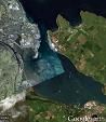
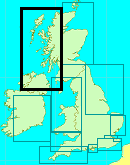
Larne Harbour and Anchorages
Courtesy Flag
Flag, Red EnsignWaypoint
54°51.7N 005°47.55WCharts
AC 1237 Chart of Larne Lough & Approaches, AC 2198 Chart of North Channel Southern Part, SC5612-15 Chart of Larne Lough N Part, SC5612-16 Chart of Larne Lough S Part, C64 Imray Chart of Belfast Lough to Lough Foyle and CrinnanRules & Regulations
Yachts should not berth on any commercial quays, including Castle Quay, without HM’s permissionHazards
Hunter Rock 2 nm north east of Harbour entrance marked by lit South and North Cardinal MarksTidal Data Times & Range
High Water Dover +0100, Belfast + 0005. MHWS 2.8m MHWN 2.5m MLWN 0.8m MLWS 0.4m (links)This site is designed for slower, roaming broadband connections, like you would get at sea, so it needs JavaScript enabled to expand the text.
General Description
Larne Port Control VHF #11 028 2887 2179
Harbour Master 028 2887 2100
East Antrim Boat Club 028 2827 7204 East Antrim Boat Club
Blue Circle Boat Club Magheramorne 028 2827 3569
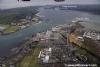
The Port of Larne is a very busy commercial harbour. It’s basically the Dover of Northern Ireland, without the Marina. There is a continuous flow of ferries, some of them high speed cats, into and out of the Ro-Ro docks on the west side of the Lough entrance both day and night; the noise is continuous.
The UKHO chart tidal diamonds show average flows through the narrows of just under 2 knots but speeds of up to 3.5 kts have been recorded. There are plenty of places to anchor (listed below) within Larne Lough once through the entrance and some of these are pleasantly secluded but the foreshore can be muddy which may preclude landing. The only anchorage which gives access to shops etc is the East Antrim Boat Club at Wymers Jetty on Curran Point and even then it’s a fair old hike through the lorry parks etc to get to them.
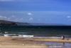
The east side of the entrance is dominated by Ballylumford Power Station and there are no shops there. There is a small Boat Dock on that side but it is very shallow and normally crowded with local fishing dories and angling boats. On the other hand the two bays outside and to the SE of the entrance (Ferris & Brown’s) offer good overnight anchorages and there is a landing spot in the SW corner of Browns Bay not too far (about half a mile) along the coast from a small shop/PO which also stocks Calor Gas. Mind you it would be unwise to use those anchorages in unsettled conditions.
The one good thing about Larne is that if you wanted to pick up crew in N.Ireland they’d only have to lugg their dunnage about quarter of a mile from the Ferry terminal to the East Antrim Boat Club to join you. (Ferries run from Stranraer, the Troon and the Fleetwood ferry have been taken out of service ).
Apart from that Larne has little to attract the cruising yachtsman - it’s a culture shock after the little harbours and anchorages around the rest of the Irish Coast and although it is an extremely good bolt hole if caught out by the weather once inside, unless already well provisioned, everything is just a little difficult and time consuming.
Approach
Tidal Information:
The tidal streams flow through the entrance normally turning at High & Low Water;
About half way through the flood a weak counter current sets in, flowing northwards past the Yellow Stone and Ballylumford “A” Jetty reaching a maximum of a knot or so at Springs, useful if trying to make an early start to catch the ebb Northwards up the Antrim coast
Approach:
Whichever way you are coming in, although it is not mandatory, you should call the “Larne Port Control” (VHF#11) and let them know your intentions.
From the North plan to pass between Ballygalley Head and The Maidens rocks to the Initial Fix (see chartlet) and watch out for ferries closing from the port bow as one closes with the No1 green buoy. Cross to the East side of the deep water channel before abeam that buoy.
From the South come round the north end of the Island Magee giving the headlands a good couple of cables offing, don’t bother with the Initial Fix or the No1 buoy, watch for ferries overtaking on the Starboard quarter and stay to the East Side of the deep water channel.
There are Lead-in-Marks on the far shore opposite the entrance but aim to come in to the left of them with the taller of the two occulting lights a bit to the left of the lower light. The harbour is accessible in all weathers day and night; the main problem at night is that the whole area is awash with lights so picking out the navigation lights will be difficult if not familiar with the Lough.
If intending to use the anchorage off Wymers Jetty, do not cross to that side until clear of Phoenix Quay, the fourth and last Ro-Ro quay on the West side.
For navigation to anchor further up the Lough the main channel is on the Eastern side with a flashing yellow buoy at the SE end. If you do intend continuing along the lough it is quite shallow in places so the usual commonsense rules apply - go on a rising tide and with a serviceable echo sounder!
Berthing, Mooring & Anchoring
There is nowhere in Larne Lough for an alongside berth;
The Boat Harbour shown on the chart opposite the Ro-Ro quays has 0.6M at LAT so would have enough water for a very shallow draught boat at neaps but even then once in, if there is room (unlikely), there is nothing here for a visiting yachtsman except the small foot passenger ferry to Larne from there. That ferry is run for the convenience of the shift workers at the power station so it would be wise to book in advance.
Further into the Lough there are numerous places to anchor the first of which is off Wymers Jetty adjacent to the East Antrim Boat club. You may be able to pick up a mooring here if you ring the Club on 02828 277204 in advance otherwise it’s a fairly congested anchorage (consider a tripping line?). Ashore there is a landing place with a water hose and fuel can be obtained in cans.
No official surveys have been done South of the Limit of Port of Larne boundary for at least thirty years, possibly more, so any recordings of depths on the available charts are historical (if not hysterical)
The deep water channel continued down the East side of the lough but after the two channel buoys to the South of the Ballylumford “A” Jetty it is unmarked. The porthand of these two buoys also marks (approx) the end of the Ballylumford outfall which, combined with the new gas pipeline has made the old anchorage opposite the “Yellow Stone” unusable. That new gas pipeline can be seen on the Google Maps satellite image - be warned!!
The first available anchorage with a landing is at Ballydowan; it’s a bit exposed to the wind from across the lough and doesn’t have anything ashore. There’s a wreck close inshore but if you anchor with the rest of the local boats here you should be ok. There is a village a mile inland towards the east coast which has a small shop and café.
A nicer spot is even further down this side at Mill Bay. The bay itself dries out so if you are a fin keeler with a 2m draught you will have to anchor quite a way out whereas a bilge keeler would be able to enter on the flood and dry out the quite close in on the gravelly bottom. The attraction here was that there was a wee pub just round the corner from the north arm of the bay - but, sadly, we believe that that hostelry is no longer trading. If you row ashore remember that, to get back, you’ll have a way to drag the dinghy when you leave the pub; unless, of course, you sit it out for twelve hours!!!! Joking apart this is a pleasant little spot to spend a summers evening.
Across the Lough there is Magheramorne. To get there, once you have passed the position of the old yellow harbour buoy at the SE end of the deep channel (Posn 59°49.9N 00546.48W0) continue SSE for another hundred yards or so and look for a yellow dan-buoy to starboard; this marks the end of the old deepwater channel in to the now disused cement works. NB This dan-buoy no longer appears on any charts so this channel may be unmarked nowadays.
Take care here to correctly identify this mid channel dan buoy (which may or may not be there as it is privately maintained); the old cement works are obscured by the artificial island from the “official” harbour buoy and will begin to open as one nears the old channel. The channel is no longer dredged but there is still a good 2.5 metres along it. There are also lead in marks by the old cement works; the front one is a red upright triangle nailed to a telegraph pole in position 54° 48.928’N, 005° 46' 049’W and the back one, a downward triangle 60M behind it (both shown on AC1237-0). The anchorage will be easily identified as there are small craft moorings here; just don’t cut the corner.
This anchorage is likely to be busier than Mill Bay as there is a club house ashore servicing the local boats. Showers, toilets and a bar may be available at the club house, they welcome visitors and there is usually a shindig of some sort or the other on Saturday nights but we have not been able to raise them for a while to confirm any details. There’s also a very posh hotel about half a mile up the road towards town.
Facilities
The only place to get full facilities is at the East Antrim Boat Club at Wymers Jetty.
Right on the end of the jetty there’s about 0.3M depth so, depending on your draught and the tide that day you might be able to get alongside there temporarily to take on water and load your fuel cans instead of rowing them out to your anchorage.
If you wanted to do this you would have to seek permission from the Secretary of the Club. There’s a pub and off-licence about ten to fifteen minutes walk through the lorry parks but for anything else you’d need a taxi into town where, of course, there is everything you could need. The Club has showers and toilets and enjoys visitors. This anchorage is always very busy in the summer; you really would be well advised to contact the club before leaving the previous harbour in order to avoid disappointment.
Other than that, the pub at Mill Bay (doubtful) and the club at Magheramorne there is nothing else in Lough Larne.
Eating, Drinking & Entertainment
Eating, Drinking & Entertainment
Larne Town is the only place with entertainment and it has the lot as you would expect. It is well endowed with good pubs for a recent list see:
http://www.beerintheevening.com/pubs/results.shtml?l=Larne&show_comments=5
There are road and rail connections to Belfast and ferries to Stranraer, Troon and Fleetwood
Links
Shipping Forecast
Malin http://www.metoffice.gov.uk/weather/marine/shipping_forecast.html#All~Malin
Irish Sea http://www.metoffice.gov.uk/weather/marine/shipping_forecast.html#All~IrishSea
Inshore Forecast
http://www.metoffice.gov.uk/weather/marine/inshore_forecast.html#LoughFoyletoCarlingfordLough
|

Got a comment to make about Larne ? Have you found this coverage helpful ? HAVE YOUR SAY (your email address will always be kept private)
Your Ratings & Comments