

Harbour Information (use the  icons to find out more)


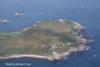
The Scilly Islands (general)
Your Comments: 3 Read or add your comments
Courtesy Flag
Flag, Red EnsignWaypoint
None appropriateCharts
AC 1148 Isles of Scilly to Lands End; 34 Isles of Scilly; 883 Isles of Scilly and the Principal Off-Islands; SC 5603 (8 to 13) Various parts of the Isles of Scilly including small scale Falmouth to Scillies; Imray C7 Falmouth to the Scillies and Trevose Head (insufficient on its own)Rules & Regulations
No anchoring in St Mary’s Pool or inshore at New & Old Grimsby. 3kt speed limit in St Mary’s PoolHazards
Innumerable!Tidal Data Times & Range
HW St Mary’s is HW Dover – 0630. MHWS 5.7m MHWN 4.3m MLWN 2.0m MLWS 0.7m There is a tidal stream diagram included.This site is designed for slower, roaming broadband connections, like you would get at sea, so it needs JavaScript enabled to expand the text.
General Description
Contacts
HM St Mary’s VHF 16/14 tel no 01720 422766538
HM Tresco (for New & Old Grimsby) tel no 01720 423 mob 07778 601237
... read more
Approach
There is extensive advice covering passage making to the Scillies.... ... read more
Berthing, Mooring & Anchoring
The main anchorages are at St Marys and Porth Cressa, New Grimsby, Old Grimsby, St Martins, and St Agnes/Gugh and they become very, very crowded in the summer months, especially in August when the French invade in gurt great tin boats. ... read more
Your Ratings & Comments
3 comments
Sheltered anchorage
Written by Tyro Sailor | 30th Jul 2022
We anchored yesterday in a Moody 346 west of Great Ganilly, south of St Martin's and north of Ragged Island. Pretty sheltered from all directions, including from the Atlantic swell, mostly deep enough and good grippy, slightly muddy sand - in between quite a lot of weed. I've never seen so much kelp but there are gaps. Further north is less weedy but shallower, and the water is so clear that I could see the bottom from the deck.
Dinghy ashore - quite a long ride to the beach next to Higher Town Quay on St Martin's.
Dinghy ashore - quite a long ride to the beach next to Higher Town Quay on St Martin's.
UPDATE SPRING 2021
Written by Don Thomson 3 | 15th Apr 2021
I reviewed these notes in April 2021. I think our member's note on relying on GPS means the CHARTS on your GPS plotter because, the GPS itself will be accurate but the charts may not have all the rocks on them. Remember to use the maximum zoom if you use Navionics. The Hotel that used to be above Old Grimsby is now holiday apartments. and the hotel on St Martins that laid buoys in Teale Sound is now part of an international consortium and it is not known if they still lay buoys.
The rocks of Scilly
Written by maryandtherib | 29th Aug 2016
Don't rely on your GPS! There are lots of uncharted bits of rock which are very shallow at low water, particularly around St Agnes where even the locals stick to routes they know. Tidal range can be nearly 6m at spring tide so it's all about the navigating.Some wonderful cardinal markers with bells which remind me of the Inchcape Rock. Some interesting bits of water where the tidal streams meet between the islands, or where deeper more exposed water meets shallow. And lots of wrecks. Lots.
Note St Mary's fuel channel is on 12, and sometimes you have to queue for a while.... take note that they close for lunch. the fuel berth is next to the Scillonian berth, but only has about 0.5m above chart datum at low water.
you can also telephone for fuel on 01720 422431.
Thanks Mary and the rib
Note St Mary's fuel channel is on 12, and sometimes you have to queue for a while.... take note that they close for lunch. the fuel berth is next to the Scillonian berth, but only has about 0.5m above chart datum at low water.
you can also telephone for fuel on 01720 422431.
Thanks Mary and the rib
4 of 4 people found this helpful

© visitMyHarbour.com | website design created by Black Culm Ltd