

Harbour Information (use the  icons to find out more)

Brucehaven & Limekilns
Your Comments: 2 Read or add your comments
Courtesy Flag
Flag, Red EnsignWaypoint
56° 01.42N 003° 29.0W (Outflow Buoy)Charts
AC 0737 River Forth, Rosyth to Kincardine; SC5615 Whitby to Edinburgh; Imray C27, Firth of Forth (with coast planRules & Regulations
None knownHazards
Drying reefs either side of the narrow harbour entranceTidal Data Times & Range
Very little data available; the Spring range is about 5 metres and the neaps about 3 metres. Nearest Easy tide data is Rosyth (links)This site is designed for slower, roaming broadband connections, like you would get at sea, so it needs JavaScript enabled to expand the text.
General Description
Contacts Harbourmaster/Moorings (volunteer) 01383 872691 07748 068061 ... read more
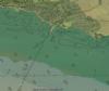
Approach
The safest approach is along the edge of the main Firth navigation channel.... ... read more
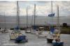
Berthing, Mooring & Anchoring
There will normally be space on one of the pontoons against the pier wall and this will be the most convenient place to tie up. ... read more
Your Ratings & Comments
2 comments
Update June 2022
Written by Don Thomson 3 | 20th Jun 2022
I reviewed these notes in June 2022 and made no changes. I'm puzzled by the query below about the waypoint - on the other hand I maybe corrected the incorrect one years ago!!
Wrong Waypoint
Written by Helly | 31st Dec 2017
Please check your waypoint.
56° 01.42N 003° 29.0W keep sence!
56° 01.42N 003° 29.0W keep sence!
0 of 1 people found this helpful


© visitMyHarbour.com | website design created by Black Culm Ltd