

Harbour Information (use the  icons to find out more)

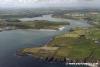
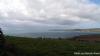
Clonakilty Bay
Your Comments: 5 Read or add your comments
Courtesy Flag
Irish TricolourWaypoint
None GivenCharts
AC 2092 Toe Head to Old Head of Kinsale; SC 5622 Ballycotton Bay to Glandore Bay; Imray C56 Cork harbour to Dingle Bay (No plan Clonakilty Bay)Rules & Regulations
None KnownHazards
All bays and anchorages have hidden rocks and Clonakilty Harbour is very shallowTidal Data Times & Range
HW Clonakilty Bay is approximately HW Cobh – 0020 MHWS 3.8m MHWN 3.0m. There is no data for LW which is a nuisance because we could do with it! Everywhere else around here has about half a meter at LWS so that will be a good working figure but it does add doubts to an already doubtful situation in Clonakilty Harbour itself.This site is designed for slower, roaming broadband connections, like you would get at sea, so it needs JavaScript enabled to expand the text.
Approach
Firstly be aware that AC 2092 relies on very old nineteenth century surveys.... ... read more
Your Ratings & Comments
5 comments
UPDATE OCTOBER 2022
Written by Don Thomson 3 | 20th Oct 2022
No changes
UPDATE SUMMER 2021
Written by Don Thomson 3 | 23rd Aug 2021
I reviewed these notes in August 2021. The Green perch at the entrance to the Clonakilty channel has been replaced by a lit WCM. Everything else is the same.
Update Summer 2019
Written by Don Thomson 3 | 15th Jul 2019
These notes were reviewed in July of 2019. No changes but new charts
Update 2015
Written by dononshytalk | 13th Apr 2015
These notes were reviewed by Don in April 2015 without changes
Update November 2013
Written by dononshytalk | 19th Nov 2013
These notes were reviewed 19th November 2013. We have added an aerial photograph


© visitMyHarbour.com | website design created by Black Culm Ltd