

Harbour Information (use the  icons to find out more)

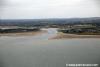
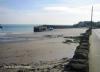
Rogerstown Inlet & Rush Harbour
Your Comments: 5 Read or add your comments
Courtesy Flag
Irish TricolourWaypoint
NoneCharts
AC44 Nose of Howth to Ballyquintin Point, AC 633 + SC5621 Rogerstown Inlet, Imray C62 Irish seaRules & Regulations
None KnownHazards
Rogerstown has a bar across its entry channel and is only approachable by keeled boats a couple of hours either side of HW. Rush harbour dries completely and has a reef to starboard of the entrance to the cove which dries from half tide onwards.Tidal Data Times & Range
As Malahide; HW is Dublin +0005; MHWS 4.4m MHWN 3.2m MLWN 1.1m MLWS 0.5m; Streams off shore in Lambay Sound reach 2.5 knots at Springs which run North from 4½ hours before HW Dublin to 1½ hours after.This site is designed for slower, roaming broadband connections, like you would get at sea, so it needs JavaScript enabled to expand the text.
Approach
The approach to Rush harbour is unmarked and without any lead in marks; ... read more
Your Ratings & Comments
5 comments
UPDATE OCTOBER 2022
Written by Don Thomson 3 | 14th Oct 2022
No changes to the notes but we have had to resort to a different tidal information site for our link (top right) as the UKHO Easytide app no longer covers Eire. The tidal info for Portraine (to the South) is the same as that for Rush (to the north)
UPDATE SUMMER 2021
Written by Don Thomson 3 | 8th Sep 2021
No changes
Update Summer 2019
Written by Don Thomson 3 | 26th Jul 2019
These notes were reviewed in July 2019 without any changes. New charts have been uploaded
UPDATE APRIL 2017
Written by Don Thomson | 26th Apr 2017
These notes were updated in April 2017. The old charts have been replaced
Update 2015
Written by dononshytalk | 20th Apr 2015
These notes were reviewed by Don in April 2105. No changes were made


© visitMyHarbour.com | website design created by Black Culm Ltd