

Harbour Information (use the  icons to find out more)

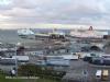
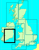
Rosslare Europort & Rosslare Strand
Your Comments: 6 Read or add your comments
Courtesy Flag
Irish TricolourWaypoint
52° 15.10N 006° 18.00WCharts
AC 1772 Rosslare Europort & Wexford Harbours; SC 5621 ; Imray C61 St George’s Channel (No Harbour Plan of Rosslare); Imray C57 Tuskar Rock to Old Head of Kinsale (No harbour Plan of Rosslare)Rules & Regulations
Contact “Harbour Operations” on VHF12 before approach and keep a listening watch at all times when moving. Remain clear of the main approach lanes and give way to all ferry movements.Hazards
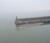
Splaugh Rock, Carrick Rock & the Calmines are all charted hazards off Greenore Point where there are also overfalls; Strong tidal streamsTidal Data Times & Range
HW is HW Dover – 0510 or HW Cobh + 0040; MHWS 1.9m MHWN 1.4m MLWN 0.8m MLWS 0.3mThis site is designed for slower, roaming broadband connections, like you would get at sea, so it needs JavaScript enabled to expand the text.
General Description
Contacts: Rosslare Harbour Operations VHF 12 tel no +353 (0)53 9157929 ... read more
Approach
The main consideration in any navigation round here is the tidal streams ... read more
Berthing, Mooring & Anchoring
Anchoring within 3 cable of the harbour entrance is prohibited and ... read more
Your Ratings & Comments
6 comments
UPDATE SUMMER 2021
Written by Don Thomson 3 | 13th Sep 2021
I reviewed these notes in September 2021. No changes were required
Update Summer 2019
Written by Don Thomson 3 | 26th Jul 2019
These notes were reviewed in July 2019. New charts were uploaded but no other changes
UPDATE APRIL 2017
Written by Don Thomson | 26th Apr 2017
These notes were updated in April 2017. The charts were updated. We can find no information on that shoal at the entrance; it may still be there
Update 2015
Written by dononshytalk | 20th Apr 2015
These notes were reviewed by Don in April 2015. No changes were made. The sandbank mentioned in the comments below is the one shown in our notes and in the picture gallery but it sounds as though it may have grown a bit more
New Sandbank in Rosslare Harbour
Written by CaraNaMara | 18th May 2014
A large deposit of sand has accumulated at the head of the breakwater and extends about 30m off shore and along the length of No. 4 Berth. This bank dries at LW but is not visible at HW. Do not use No. 4 Berth and contact Rosslare Harbour on CH 12 before entering.
Update December 2013
Written by dononshytalk | 11th Dec 2013
These notes were reviewed on the 11th December 2013; no changes were made


© visitMyHarbour.com | website design created by Black Culm Ltd