

Harbour Information (use the  icons to find out more)

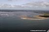
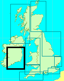
Wexford
Your Comments: 7 Read or add your comments
Courtesy Flag
Irish TricolourWaypoint
52°19.14N 006°19.39W (Wicklow Bar Buoy SWM)Charts
AC1772 Rosslare Europort & Wexford; SC5621-15A Wexford and Rosslare; Imray C61 St Georges Channel (Wexford Port Plan)Rules & Regulations
None KnownHazards
Narrow navigation channel with changing depths and routing; Off shore shifting banksTidal Data Times & Range
HW is HW Dover – 0450 or HW Cobh + 0130; MHWS 2.0m MHWN 1.5m MLWN 1.0m MLWS 0.5m In the Bay the tidal streams are not strong and flow in and out with the tide but once between the training walls and in the harbour the streams are quite strong reaching 2kts at springs and can be even stronger after prolonged periods of heavy rain (in Ireland??)This site is designed for slower, roaming broadband connections, like you would get at sea, so it needs JavaScript enabled to expand the text.
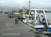
Berthing, Mooring & Anchoring
The berths on the town side of the harbour are normally ... read more
Your Ratings & Comments
7 comments
UPDATE OCTOBER 2022
Written by Don Thomson 3 | 18th Oct 2022
I reviewed these notes in October 2022. The information it contains is the most up-to-date that we can find but some of it is two years old. We cannot emphasize enough the need to consult every source in case it may contain recent up dates. The WBC Facebook page is normally fairly new.
UPDATE SUMMER 2021
Written by Don Thomson 3 | 16th Sep 2021
I reviewed these notes in September 2021. I've updated the links to the latest information available. Use those charts as an indication of roughly where to look for the next lateral mark. Use the mark1 eyeball, not the chart plotter, to get in
Update Summer 2019
Written by Don Thomson 3 | 30th Jul 2019
These notes were reviewed in July 2019. The people at Wexford are doing an extremely good job in keeping the rest of us up-to-date with the navigation through Wexford Bay. Be advised that the Navionics information is based on the Wexford input and covered by the Wexford blanket warning not to use it for navigation. We have uploaded this year's Admiralty chart - which does not supply the Wexford info so you can't be misled by it.
UPDATE APRIL 2017
Written by Don Thomson | 26th Apr 2017
I reviewed these notes in April 2017. The Sailing Club here do a marvellous job in keeping the buoyage up to date; it is imperative that you consult them verbally before committing to an approach or you will end up on another RNLI video
Update November 2015
Written by dononshytalk | 4th Jan 2016
The channel here has changed markedly from that of 2010/2011. Do not rely on memories from previous years and make sure that the information you are relying on is current. The channel in 2015 crosses areas that were previously impassable.
Update 2015
Written by dononshytalk | 21st Apr 2015
These notes were reviewed by Don in April 2015. Sailors here owe much to the members of the Boat Club who diligently maintain the channel buoyage. A visit to their Face Book page is a must when planning your entry here.
Update December 2013
Written by dononshytalk | 12th Dec 2013
These notes were reviewed on 12th December 2013 by Don Thomson. The changes at the harbour end of things are minimal but the Estuary continues to be an ever shifting scenario. Their Face Book page is a "must read" as things can change on a monthly basis


© visitMyHarbour.com | website design created by Black Culm Ltd