You are viewing the expanded version of this Harbour,
for faster browsing
use the regular version here

Newtown River
Courtesy Flag
Flag, Red EnsignWaypoint
Safe Distance off , NNW of the West Cardinal Buoy. 50:43.75'N 001:24.89'WCharts
Admiralty 2021, 2035, 2036, SC5600Rules & Regulations
5 Knts Speed LimitHazards
Tricky Entrance, Unlit, Extensive Shallows Within.Tidal Data Times & Range
Double HW or long stand, First HW springs approx. -0030 Dover MHWS 3.4m MHWN The tides here virtually the same as those for Yarmouth. Tide tables: (links)This site is designed for slower, roaming broadband connections, like you would get at sea, so it needs JavaScript enabled to expand the text.
General Description
Newtown Creek and its associated branches form a peaceful haven for nature, and a useful anchorage for yachtsmen and motorboaters.
It is probably one of the most natural and unsullied anchorages in the whole of the Solent area. The estuary is now owned by the National Trust, who maintain a number of visitors moorings...
It is best visited off-season or mid-week, as at busy periods the place really fills up, and the whole reason for going there is somewhat spoiled by close proximity and anchoring antics of the irritating kind. There is not an awful lot of room to swing.
This is not the place for provisioning, watering up or having a wild night out ashore. There is a small boatyard with some drying moorings for small shoal draft craft at Shalfleet. A dinghy mission from the moorings/anchorage a couple of hours either side of high water will get you there and then an equally determined hike will bring you to the tiny one shop/one pub village.
Anchorage is free, although you may be expected to cough up a donation to the National Trust. Mooring buoys are chargeable.
Off-season you're unlikely to be bothered by anyone.
This drone video gives a good idea of what to expect during the summer season
Approach
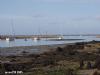
Newtown River is approached via a narrow channel leading through shingle banks. Entry for most boats is only possible with a suitable rise of tide, but once within deeper water will be found.
Pilotage details now follow:
From the West locate and identify the green conical Hampstead Ledge Buoy (Fl (2).G.2s), and from the East keeping a good distance off, locate the westerly cardinal fairway buoy (Q.(9)15s).
Quite often the best clue from a distance is sighting the masts of the boats at anchor inside. The spit forming Spithouse Point is very low lying. In either case approach the westerly cardinal buoy on a southerly or south-easterly heading. This is the only lit navigational mark, so a night entry although not impossible would need a great deal of care on a rising tide.
The tidal patterns are worthy of a mention, with a stand of around two hours at HW, preceded by seven hours of flood tide. This makes the three or four hour ebbtide particularly strong, especially in the narrow entrance. The HM here advises the use of the Yarmouth tide tables here as they are virtually the same.
The channel leading in has water at all states of the tide (about 1.5m at LWS) but is narrow and steep sided, so deep keeled craft are advised that it's best to enter on a rising tide. The tide can run hard through the narrow but deep entrance.
Leave the west cardinal buoy marking the entrance channel to port and make your entry on a course of about 130°. You should pick up the leading marks easily. The forward Mark consists of a red & white striped post with a Y shaped top mark (like the rearsight on a rifle), and the rear post which is higher and mounted on dry land has a white circle. Keep these two dead in line and approach. There used to be a green buoy opposite the forward leading mark but this has been removed so there is no indication of the extent of the western side of the channel. In the closer approach to the Y shaped mark, the entrance will be in clear view and it is then necessary to come off the transit, make a slight swing to starboard and head straight towards the entrance. Be aware that the front leading mark is laid in shallow water and should be given about 40yds offing. The red post in the entrance on the Admiralty Chart is being removed (Spring 2014) and the deepest water continues in a straight line. Ahead, on the starboard bow, lie two green conical buoys (one with a top mark) and, on the port bow, a BRB bad ground mark (This post has been replaced by a Red/Black striped buoy with two ball top mark but no lights) and green conical buoy. A choice now needs to be made about mooring and anchoring; if going up Newtown Creek swing to starboard and leave the two SHMs to starboard and the bad ground mark to port; if going up Clamerkin Lake, round the bad ground mark to port and pass between it and its accompanying SHM (buoy with conical top mark).
Most of the above IALA lateral marks have now been replaced with small Buoys
Berthing, Mooring & Anchoring
Options are either to find a vacant visitors mooring buoy, or to anchor.
Space is tight, there are large drying areas, and if you're looking for a quiet time it is best to avoid summer weekends. Newtown Creek is best savoured off-season. The options are now explored:
There are 15 mooring buoys laid in the Newtown River (the branch that leads to Shalfleet Quay) and 5 in Clammerkin Lake, to port as you enter. These white moorings are for visitors, and if you use one of them, the charges (2020) about £25.00 for boats up to 11m per night and £13.50 for a short stay. There is sufficient room between the buoys in Clammerkin Lake to lay an anchor but not in the Newtown River where they are laid on a ground chain.
Space is tight for anchoring, remember most of this dries out at low water, and Clammerkin Lake is really the only place where there is room. When you enter, take note of the BRB buoy on your port side as you follow the deep water down ( marked on the starboard hand side by a green buoy and a green post with conical top marks). If you need to go Clammerkin Lake to anchor the safest bet is to make your turn to port immediately after passing the BRB buoy. At high water it may look tempting to commence your turn earlier, but the deepest water is as described. The buoys are well maintained but can be a bit confusing for a first-time visitor, and as always in these circumstances it is best to arrive on a rising tide with a careful eye kept on the depth sounder.
Finding room to swing in Clammerkin Lake is not always easy either, the danger being that as the tide turns you can swing onto the mud. Following this channel round a bit more you'll come to oyster beds with boards advising "Anchorage Limit". By this time the Creek is narrowing substantially (although at high water it really does look like a lake), with only a narrow gutway remaining with about 1 m at LWS. The holding ground is good being mud.
During busy periods when the anchorage is crowded (especially in wind against tide situations) be prepared for anchoring antics.
Probably the most seaman like way of anchoring in these narrow channels would be the Bahamian Moor, with one anchor uptide and one anchor downtide..... unfortunately you can practically guarantee even if you buoy the anchors that there will be others who do not understand what you are doing and who's larger swinging circles will interfere with you. Nevertheless anything you can do to keep your swinging circle small will help. With the holding being so good it is not necessary to pay out fathoms and fathoms of chain.
During peak periods the most irritating thing is that just as you're settled down, happy with your swinging circle and your holding..... someone will come anchor right on top of you.
As mentioned before, Newtown is best enjoyed away from busy periods.
Facilities
Not a lot... water is available from a tap at the end of the footbridge adjoining Newtown Quay.... make a dinghy landing around three hours either side of high water by the hut. A short walk inland from here will reveal the village of Newtown, which boasts...... nothing !! No pub and no stores. Marvel at the fact that this town once possessed two MPs, and was of more commercial importance than Newport (check the history section).
Following the main branch of the Newtown River (in the dinghy) will bring you to Shalfleet Quay, with its little boatyard and slipway. From here you can walk to Shalfleet Village, as described in the opening section. Southern Vectis buses stop outside the New Inn (which in fact looks remarkably old), for transport to Newport eastwards, or Yarmouth westwards.
History
Newtown is a small hamlet on the Isle of Wight, in England.
Newtown is located on the large natural harbour on the island's north-western coast, now mostly a National Nature Reserve owned and managed by the National Trust.
The Caul Bourne stream running through Calbourne passes through Newbridge and Shalfleet and empties into the Solent at Newtown.
History
The town was originally called Francheville (i.e., Freetown), and only later was it renamed Newtown. It probably was founded before the Norman Conquest. There is some indication that it was attacked by the Danes in 1001.
The earliest charter that we know of was granted by the Bishop-elect of Winchester, Aymer de Valence. He signed its charter at his ecclestical estate at Swainston Manor in 1256. The high hopes for its success are reflected in the names of its streets, such as Gold Street and Silver Street. However, it might have suffered from competition from Yarmouth, Newport and Southampton. In 1284 the village was somewhat reluctantly given to Edward I. Apparently there were some 60 families living in Newtown at the start of the 1300s.
By the mid 1300s, it was slowly starting to mature into a thriving commercial center. In 1344, it was assessed at twice the value of Newport. Its harbor was busy and reputed to be the safest on the island. There was a prosperous saltworks and Newtown was famous for its abundant oyster beds. There was an annual three day festival on the "eve, the day and the morrow of the Feast of St. Mary Magdalen", who was honored in the name of the local thirteenth-century chapel. Then the plague struck, and a French raid in 1377 destroyed much of the town as well as other Island settlements. It has never fully recovered from this blow.
By the middle of the sixteenth century it was a small settlement long eclipsed by the more easily defended town of Newport. A survey in 1559 noted that Newtown no longer had a market and it did not have a single good house still standing. Its harbor slowly became clogged with silt so that it was not accessible to larger vessels.
Elizabeth I breathed some life into the town in 1584 by awarding it two parliamentary seats. A town hall was built in the 17th century. However, these two parliamentary seats ultimately made Newtown one of the most notorious of the rotten boroughs, prevalent in the UK before reforms in the 1800s. By the time of the Reform Act 1832 that abolished the seats, a survey pointed out that Newtown had just fourteen houses and twenty-three voters. Much larger municipal areas with many more voters had less representation.
The town hall was restored in 1813, and again in the 1930s. It is now open to the public.
The Newtown Arms Inn was closed in 1916. It was in an unusually shaped building locally referred to as "Noah's Ark."
Newtown has stayed small, but this has led to the preservation of the original layout of the village, to the interests of historians. There are also two square ponds by the boathouse which were dug as salterns, as part of a salt industry that used to exist in Newtown.
The text on this HISTORY page is covered by the following licence
http://en.wikipedia.org/wiki/Wikipedia:Text_of_the_GNU_Free_Documentation_License
Eating, Drinking & Entertainment
The New Inn just mentioned is the only place that can be reached (with a bit of a dingy mission and a hike ashore). It has won awards for the Isle of Wight Dining Pub of the Year, carries real ales and specialises in seafood. The big open log fire can in some circumstances create as much of a fug as a table full of chain smokers, but it's authentic as are the flag stone floors. Well worth a visit if safely tied up on a mooring buoy. It closed in 2018 and has since been re-opened by the owners who were the award winning team of earlier years.
Links
None
Your Ratings & Comments
I anchored in Clammerkin Lake between the 2 white visitors buoys. When I pulled up the anchor chain it was wrapped around a large sunken tree branch, about 15ft long. I did lift it by hand but a bit of a surprise. Needless to say I was not dragging my anchor!
Is it possible to reserve/pay in advance for mooring buoys in Newtown? I am organising a rally on 4-5 June for 4 boats. We would like to stay in Newtown and obviously closely moored as we will either be having a beach BBQ or heading up to the new inn. Any contact numbers for the harbour masters would be great to know????
SYC
www.sundowners.org.uk
Prices have been adjusted for 2014