

Harbour Information (use the  icons to find out more)

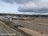
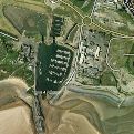
Burry Port
Your Comments: 8 Read or add your comments
Courtesy Flag
Flag, Red EnsignWaypoint
Offing from Bury Inlet: 51º38.15'N 004º21.86'W Barrel Post: 51º40.46'N 004º15.01'WCharts
AC 1076Rules & Regulations
Hazards
Dries out, dangerous in strong onshore winds, shifting sandbanks, strong tidal streamsTidal Data Times & Range
HW Dover -0455 MHWS 8.6m MHWN 6.6m MLWS 1.1m MLWN 3.0m (links)This site is designed for slower, roaming broadband connections, like you would get at sea, so it needs JavaScript enabled to expand the text.
Approach
Camarthen Bay shelves steadily towards the mouth of Burry Inlet. You should note that the old Burry Port Inlet chart has been discontinued ... read more
Berthing, Mooring & Anchoring
There is a speed limit of 3 knts within the marina, ... read more
Your Ratings & Comments
8 comments
Current situation at Burry Port Marina
Written by serenmor | 17th May 2026
Carmarthenshire council have now taken over the running of the Marina, and are about to begin dredging works - the marina has silted up badly over the years. so access is restricted to small boats and bilge keelers at the moment, and entry and exit near HW. The staff there are very friendly, and if you can manage the awkward navigation it is worth a visit. ( May 2026). The town itself is getting better, with some nice pubs and restaurants, and a co-op supermarket a short walk away.
Silted up - and nobody there
Written by peter.evans | 11th Jun 2024
I tried to visit Burry Port 22 May 2024.
Phoned beforehand, nobody answered. Tried five times. Should have taken that as an indication.
Weather ideal, no problem in the channel.
One hour before HW attempted to enter. Taken aback by large sandbanks in all directions, and ran gently aground about 15 metres inside (I draw 1.2m, bilge keel) .
Was able to back off against the incoming current and turned tail and fled.
Had a very comfortable night anchored in the channel to the southwest.
Afterwards googled Burry Port and found the company has gone bust and the silting is uncontrolled.
Should have done that BEFORE I went!
I live and learn ...
1 of 1 people found this helpful
UPDATE SEPTEMBER 2022
Written by Don Thomson 3 | 29th Sep 2022
I reviewed these notes at the end of September 2022. They are still in the development stage here with a lot promised. meanwhile there is less than the advertised 1.5 metres depth in places and the amenities are in temporary accommodation.
UPDATE SUMMER 2021
Written by Don Thomson 3 | 22nd Sep 2021
I reviewed these notes in September 2021. They are still involved with dredging the marina before they refurbish and add pontoons. The building work ashore is about to be started. So, as we write, there is a lot going on but not much in the way of change yet.
UPDATE SPRING 2018
Written by Don Thomson | 23rd Apr 2018
There is a lot happening here. The Marina has just been taken over by The Marine Group which has big plans for the place. The flap gate is expected to be functioning early in the summer whilst the marina and close approach will be dredged idc The RNLI Boathouse will be come the harbour office and amenities block whilst the RNLI will be rehoused.
1 of 1 people found this helpful
Oct 2017 - Cill has been removed
Written by julianc | 11th Oct 2017
As of October 2017 the western half of the cill has been dismantled and is sitting on the harbour wall.
At low water the harbour now dries to hard sand.
We couldn't establish if this is winter maintenance or if the harbour is now out of action.
There are a few dozen boats on the pontoons. They have all taken the ground apparently without problem
Ed note. The equipment sitting on the harbour wall is the elements of the storm gate and nothing to do with the cill.
1 of 1 people found this helpful
Update Spring 2016
Written by dononshytalk | 28th Apr 2016
These notes were reviewed by Don in April 2016. This entry remains an almanac stubb and is not based on personal experience.
Update 2103
Written by dononshytalk | 15th Feb 2013
The Burry Port notes were updated by Don T on the 15th February 2013 and the new prices noted

© visitMyHarbour.com | website design created by Black Culm Ltd