

Harbour Information (use the  icons to find out more)

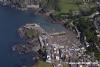
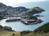
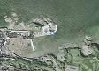
Ilfracombe Harbour
Your Comments: 5 Read or add your comments
Courtesy Flag
Flag, Red EnsignWaypoint
None GivenCharts
AC 1160 SC5608Rules & Regulations
Hazards
Up to 3 Knt stream across the approach line at springs, Overfalls W of Rillage Point (known as the "Buggy Pit")Tidal Data Times & Range
HW Dover-0525 MHWS 9.2m, MHWN 6.9m, MLWS 0.7m, MLWN 3.0m (links)This site is designed for slower, roaming broadband connections, like you would get at sea, so it needs JavaScript enabled to expand the text.
Berthing, Mooring & Anchoring
Anchor by carefully nosing into the Outer Harbour, watching out ... read more
Your Ratings & Comments
5 comments
UPDATE SEPTEMBER 2022
Written by Don Thomson 3 | 26th Sep 2022
I reviewed these notes at the end of September 2022. They have added three RED buoys to seaward of the yellow Visitor's buoys in the outer harbour; these are for use by commercial operators (mainly red ribs for trippers)
I've added a link to the yacht club website and edited the link to the webcam. harbour dues have increased.
I've added a link to the yacht club website and edited the link to the webcam. harbour dues have increased.
1 of 1 people found this helpful
UPDATE SUMMER 2021
Written by Don Thomson 3 | 24th Sep 2021
I reviewed these notes in September 2021. No changes except the price for visiting yachts.
1 of 1 people found this helpful
UPDATE SPRING 2018
Written by Don Thomson | 23rd Apr 2018
Very little has changed here. The price has gone up a little.
Update Spring 2016
Written by dononshytalk | 19th Apr 2016
These notes were reviewed by Don in April 2016. Only change is the price for this season
1 of 1 people found this helpful
Approach from the West
Written by dononshytalk | 21st Oct 2011
Most of the local yachtsmen ignore the Horseshoe buoy off Bull Point. The Point itself is "steep to" and, although there is a noticeable increase in the swell as one passes, the overfalls do not start until a good quarter of a mile off the Point - fifty yards off and you save a very long treck around the buoy.
On the other hand, the next navigation point to the West is Mortpoint buoy and you go inside that at your peril!!
For drinking & entertainment - there are at least six pubs/eateries looking out over the harbour - the only problem is rowing back out to your boat!!!!!
On the other hand, the next navigation point to the West is Mortpoint buoy and you go inside that at your peril!!
For drinking & entertainment - there are at least six pubs/eateries looking out over the harbour - the only problem is rowing back out to your boat!!!!!
4 of 4 people found this helpful

© visitMyHarbour.com | website design created by Black Culm Ltd