You are viewing the expanded version of this Harbour,
for faster browsing
use the regular version here

St Ives (North Cornwall)
Courtesy Flag
Flag, Red EnsignWaypoint
50°12.80N 005°28.00WCharts
AC 1149 Pendeen to Trevose Head; AC 1168 plan of St Ives Bay; SC 5603.4B St Ives Bay; Imray C7 Falmouth to Isles of Scilly & Trevose Head (Plan of St Ives)Rules & Regulations
Don’t feed the wretched seagulls!!!!Hazards
The Stones & Overfalls off Godrevy Island; Rocks off St Ives Head and off Porthmeor Beach; the Carracks off Porthminster PointTidal Data Times & Range
HW is HW Dover – 0610. MHWS 6.6m MHWN 4.9m MLWN 2.4m MLWS 0.8m (links)This site is designed for slower, roaming broadband connections, like you would get at sea, so it needs JavaScript enabled to expand the text.
General Description
Contacts:
Harbour Master Tel 01736 795018 VHF 16/12 tel no 07933 173958
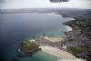
St Ives harbour is tucked into the western corner of St Ives Bay 15 miles north east of Lands End. That puts it about thirty miles from Penzance and forty miles from the Scilly isles. It is one of a number of harbours on this coast which serve the inshore fishing fleet and is visited by yachties in the summer.
The harbour mouth is very wide and faces South but on-shore weather from the North can turn in and make it fairly boisterous; as well as this, although there is not much sea room for swells to develop in Easterly weather, winds from that sector can make it and the anchorage outside untenable.
There has been a fishing port here since the dim and distant past; the first pier was built here in the late 1700s and then when the railway came through in the 1870s it blossomed into the town we see today. The railway was initially for the fish landed here but the Victorians soon found it and it became a holiday destination and popular spot for artists as the light is so clear.
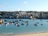
The town itself is idyllic in early to mid May and again in September but in August it is a nightmare. Holiday makers flock here and pack the streets around the harbour; some even attempt to (and regret) drive their cars through but the pavements spill over with pedestrians and movement can be almost impossible.
The harbour front is a long line of fish & chip shops and pubs and if you are lucky enough to find an empty seat to eat your take away meal you’ll find that the seagulls insist on sharing it with you (they can and will grab the whole lot in a fly-by hijacking!) So, be warned, if you come here in mid summer you will not have the place to yourself; on the other hand, at either end of the season, it is lovely, as are all the other Cornish harbours. The one advantage of being a holiday hotspot is that it is set up to maximise the visitor trade and you are a visitor!
Approach
if you intend coming inside the harbour you will need
..... to arrive a couple of hours either side of HW or you will have to anchor or moor off to await the water. That’s ok from the South because you can come up with the flood; from the North you will have to peg the tide which, once you are south of Trevose head, only reaches a maximum of about 1.5 kts at Springs so it’s not too bad.
From the South coming round Lands End you can choose to go outside the Longships Light or, in settled weather and by day, come up through the Longships Channel. Ideally you would leave your departure point on the South Coast in time to take the English Channel ebb down to Lands End, pass that at slack and take the flood up to St Ives; obviously give the Runnel Stone a good offing and, once through the Longships Channel (AC 2345-5 makes it seem at lot less daunting than a smaller scale chart and is available in the Members area of this website), give all the headlands between there and St Ives Head at least a couple of cables.
This is an incredible bit of coastline and in onshore weather downright dangerous so treat it with respect. On the other hand, with settled conditions (on shore or off shore), sailing off here just on the limit of where the wind lifts to clear the cliffs (about half a mile off) is an experience not to be missed. If coming from the North you just have to sail down the coast and give the Stones off Godrevy Island a miss. Although the Sound between Godrevy Island and the Stones looks as though it might be shorter, unless you are racing, it saves only 3 cables if coming from Newquay and is not worth the sweat.
If you are coming out of the Bristol Channel be sure to pass through between Lundy & the mainland on the ebb – the flood can stop you dead.
Run into our Initial Fix from the North and you’ll be clear of all dangers but if approaching at night be aware that boats on moorings and at anchor in the bay do not always carry anchor lights so be ready for some drastic course alterations at the last minute!
Berthing, Mooring & Anchoring
As has been said you can only get into the harbour a
.... couple of hours either side of high water and if stopping you will need to be able to take the ground. There are four drying moorings laid opposite the west quay which will cost you £18 per night up to 12 metres.
It is no longer permitted for visiting boats to tie up alongside in the harbour
Other than that you can anchor in the bay but it’s a long row into the harbour if you haven’t an outboard for your dinghy.
Ed Note. They are negotiating for an ammendment to the HRO to permit the harbour to lay moorings in the bay but that will not happen until late 2023 or (more likely) the 2024 season.
The harbour website can be found at St Ives - Cornwall Harbours
Facilities
This is not a marina! You’ll find water at one of three taps on Smeaton Pier, the HM has the keys for the showers so you need to catch him in his office to get those.
There’s a chandlery which services the fishing fleet and you can get both Gas & Gaz in the hardware shop.
Main problem is that there is no garage in St Ives so no petrol or diesel; the HM does have red diesel but he is no longer allowed to serve it to yachts or leisure craft but he is aware of the problem and in cases of dire need has a van which he will transport cans.
Eating, Drinking & Entertainment
St Ives is geared up for the holiday maker so you will be well catered for here; loads of pubs, restaurants and fast food outlets. There is access to the whole of the Cornish travel network from the railway station with trains every hour to Plymouth via Penzance; if you intend going round the corner to Mousehole or Penzance as the next leg of your odyssey you can always go and have a look before you depart! A good website to discover everything available is
http://www.onestives.co.uk/index.html
Links
|