You are viewing the expanded version of this Harbour,
for faster browsing
use the regular version here

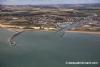
Newhaven Harbour
Courtesy Flag
Flag, Red EnsignWaypoint
W. Breakwater Head 50:46'.545 N, 000:03'.505 ECharts
Admiralty, 2154, SC5605Rules & Regulations
IALA Traffic Signals, All Yachts Report Harbour Control, see textHazards
FerriesTidal Data Times & Range
HW Dover +0004 MHWS 6.7m, MHWN 5.1m, MLWN 2.0m, MLWS 0.4m. Tide-tables: (links)This site is designed for slower, roaming broadband connections, like you would get at sea, so it needs JavaScript enabled to expand the text.
General Description
Contact
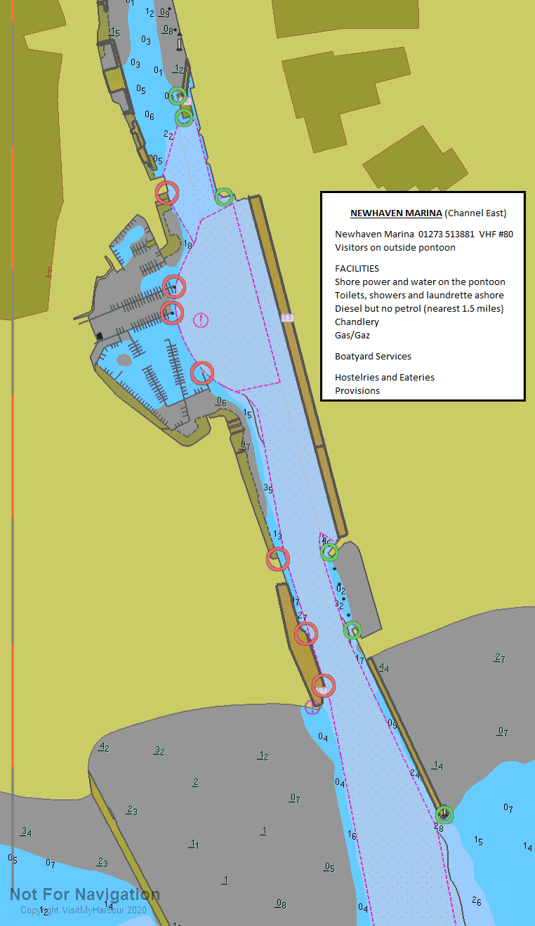
Newhaven Marina 01273 513881
Newhaven lying to the west of Beachy Head, used to be the only viable port of call between Dover and the Solent.
Since then new leisure harbours have been opened first at Brighton and then at Eastbourne. Until recent years the facilities for yachts had not really moved with the times but nowadays the small marina in Sleepers Hole has had its facilities brought up to date and is dredged four times a year so that there should be no trouble with water depths on the visitors pontoons There could be the outside possibility for a 2m draft boat to touch bottom at very LWS on the inside of the pontoon but the bottom is pretty liquid mud and there have been no recent records of problems.
It looks as though Newhaven may have reverted back to former times and seldom has a berth for visiting yachts having given priority for these berths to Windfarm support vessels
The land between the marina and the town has been built on and there are further developments planned which makes the shoreside a bit more salubrious than hitherto though there are some grim looking dilapidated and unused buildings on the eastern side of the harbour.
The harbour has a fairly active fishing fleet and is also base for cross-channel ferries. These ferries have to turn themselves around right off the marina, furthermore the entrance is fairly narrow, so good understanding of the traffic signals is necessary. If you look at the photo gallery on the Newhaven Marina website (URL below) the first picture has a ferry leaving harbour - there's no room for anything else!! The turning of the ferry may make fascinating watching the first couple of time but if you stay here for any length of time it, and the noise they make, could get tiresome.(Especially as they have boats arriving and departing in the middle of the night)
The Marina maintains some visitors berths and all facilities of the town are close on hand so stocking up shouldn't be a problem.
NEW WINDFARM ALERT
For details of the new Rampion Windfarm in the Channel to the South West of Newhaven click in this link Windfarm Alerts
Approach
If approaching from the east the yachtsman or motorboater will probably stay outside of the Royal Sovereign shoals....
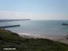
.... and pass the cliffs of Beachy Head at some distance off. It is then a matter of closing the coast while maintaining a safe offing. The town of Seaford will be seen lying about 5 miles west of Beachy Head. In the closer approach Burrow Head lies at the western end of Seaford Bay, and Newhaven nestles just to the east of this. It is easily recognisable with it's big Western Breakwater, the end of which is surmounted by a very conspicuous lighthouse (Oc(2)10s.17m.12M).
Pilotage Details:
If approaching from the West keep a good offing, ideally at least a mile off Burrow Head.
In either case the best approach to Newhaven is made with the entrance bearing due North, and commencing your run in from some distance off. Pass the Western Breakwater with it's lighthouse fairly close to your port hand side. Aim for the much smaller East Pier (which has changed to Q.G.5M) and enter. This track keeps you within the dredged channel.
There is plenty of water outside the dredged channel to the East and in normal conditions this can be used.
However.... in strong on-shore winds there are likely to be rough seas at the entrance of the harbour. Breaking seas on the eastern side of the dredged channel may well be experienced. Yachts are advised to pass close to the breakwater in these conditions, and to stay in the dredged channel.
Standard traffic signals are displayed on the Western bank of the river at the entrance. They consist of three red, green and white lights arranged vertically, and the meanings are described below:
3Fl.R (vert) Port closed. Emergency
3F.R (vert) Port Closed
GGW (vert) Port Open, Two way small boat traffic.
GWG (vert) Permission to enter/depart required, (Normally means large ship is entering or departing, all vessels to keep out of the channel unless they have specific permission)
These signals are also shown in pictorial form in our photo Gallery
The traffic signals must be obeyed so keep an eye out in your approach, and all pleasure craft entering the harbour should report to "Newhaven Radio" on VHF channel 12.
Berthing, Mooring & Anchoring
Newhaven Marina have some visitors berths available, the best plan is to call them on VHF channel 80 or telephone 01273 513881.
Visitors are normally accommodated on the outermost pontoon, which is the first you come to on your port hand side. But see our member's note of 2017 to the effect that the Windfarm Traffic has taken over the visitors berths and there will probably not be a berth available.
We've had a chat with this marina about the availability of visitors berths. Although they are quoting 20 visitors berths on their website some of those could be occupied by wind-farm boats at any one time. We pointed out that with a limited number of berths and no reservations allowed it wasn't satisfactory to say they would try to fit a visiting boat in if there was anything available; especially as the entrance was tide restricted so all visitors would arrive on the last of the flood without the option of going elsewhere. It appears that they want visitors but only to fill up spaces that they haven't filled up with other boats.
We have added a marina layout to the Navigation Images this year.
More details and prices:
Deep draught vessels drawing around 2 m may possibly experience problems at dead low water springs, especially if trying to lie on the inside of this pontoon. The bottom is soft mud so once installed there should be no problem. Shallow draught boats of say 1.5 m shouldn't have problems. When you think of it you'll be coming in on the flood and departing pretty well at the beginning of the ebb so really no problem at all if your boat dips its keel into soft mud while your there!!
Charges here (2022) come out at £28.00 a day 10 m boat. Vessels much larger than 15m cannot be accommodated here. Prices include water and electricity.
Short stays (max 5 hours are £12.00
http://www.newhavenmarina.co.uk/
Updated March 2022
Facilities
Facilities at the Marina include water and electricity (included in the mooring fee) on the pontoons, full toilet and shower facilities with weather forecasts and public telephones. Marine diesel is available seven days a week from 9 AM to 4 PM. Nearest garage for petrol is probably Sainsburys which is over the bridge about a mile away. If you need Calor or Camping gas refills I'm afraid you have to go up to Peter Leonards Chandlery on Denton Island for that (just over half a mile)
There are hauling out facilities at the Marina, and also a scrubbing hard in case you have a dirty bottom....
Trailer Sailer's have a couple of options, the first being Simpson Marine, who can launch boats up to 23 feet long. Access is available for most of the tidal range with the charge of £15 for launch and recovery.
Even larger boats can be handled at Newhaven Marina who have a substantial launching ramp.
Various marine services are available nearby including chandlers and divers, check the business directory.
The town although not large can handle most provisioning requirements ( including Sommerfield's and Sainsbury's), banks with cashpoints are available.
Transport-wise Newhaven is served by two stations, and is on the branch line to Lewes, from where other connections can be made. Buses also cover the nearby areas.
More Info
Tidal Streams - At a position about 1.7 miles 175° from the head of Newhaven breakwater the east-going stream, spring rate 1.6 knots neap rate 0.9 knot, mean direction 105° , begins -0535 Dover; the west-going stream, spring rate 1.1 knots neap rate 0.6 knot, mean direction 280° , begins -0015 Dover.
Off the harbour entrance the west-going stream begins about -0130 Dover, but it is very weak and of no consequence inside the breakwater head. In the entrance both the flood and ebb streams attain a rate of about 2 knots at springs; the flood stream begins about -0545 Dover; the ebb streams begins about +0010 Dover. The streams decrease as the harbour widens.
History
Newhaven is a town in the Lewes District of East Sussex in England. It lies at the mouth of the River Ouse, on the English Channel coast, and is a ferry port for services to France.
Newhaven lies at the mouth of the River Ouse, in the valley the river has cut through the South Downs. Over the centuries the river has migrated between Newhaven and Seaford in response to the growth and decay of a shingle spit (shoal) at its mouth.
There was an Iron Age fort on what is now Castle Hill.
In about 480AD the Saxon people established a village near where Newhaven now stands, which they named "Meeching" (variously known as "Myching" or "Mitching").
Throughout the Middle Ages the main outlet and port of the Ouse was at Seaford (one of the Cinque Ports).
The growth of the shingle spit hindered the outflow of the river, which consequently flooded the Levels upstream and hindered access to the port. Therefore a channel through the shingle spit was cut in the mid-16th century below Castle Hill, creating access to a sheltered harbour, better than that at Seaford. This was the origin of modern Newhaven.
However, shingle continued to accumulate and so the mouth of the Ouse began to migrate eastwards again. Under the Ouse Navigation Act (1790) a western breakwater was constructed to arrest longshore drift and so cut off the supply of shingle to the spit. A new outlet (The Cut) was built on the river’s present course, below Castle Hill. At that time the settlement began to be known as the ‘’new haven’’. The present breakwater was built in 1890.
Port
Newhaven was well-used during the both World Wars. It was designated as the principal port for the movement of men and materiel during World War I; during World War II large numbers of Canadian troops were stationed here, and the ill-fated Dieppe Raid in 1942 was largely launched from Newhaven.
From the port of Newhaven international ferries run to the French ports of Dieppe (Transmanche Ferries); and to Le Havre, (LD Lines) Although there are some derelict signs of the one-time train ferry operations, the harbour still sees a great deal of freight and passengers movement, with both the ferries running from this port being under 3 years old.
The Newhaven Lifeboat, the first of which was commissioned in 1803, is among the oldest in Britain. Newhaven also has one of the Watch stations of the National Coastwatch Institution
Industry
To the east was the village of Tide Mills, built in 1761, and now derelict. Here are the remains of workers' cottages, the tide mill itself, and a large saline lagoon which was the storage pond for high water to power the mills on the outgoing tide.
The Newhaven Marconi Radio Station was established in 1904, and started running in 1905. The station was owned and operated by the Marconi Radio Company and achieved regular ship to shore radio communications in approximately 1912.
The Heritage Marine Hospital was built in 1924 wto cater for disabled boys who had undergone surgery. It became a casualty of wartime defence work during World War II.
Today the Denton Island Business Park lies to the north of the town on the east bank of the river.
Military
Newhaven Fort, one of the Palmerston Forts, was built on Castle Hill on the recommendation of the 1859 Royal Commission to defend the growing harbour It was the largest defence work ever built in Sussex and is now open as a museum.
The adjacent village of Tide Mills was the site of an experimental seaplane base at the head of the beach. The first formation of No. 242 Squadron RAF was on 15 August 1918 from numbers 408, 409 and 514 Flights at the seaplane station at Newhaven, Sussex. Operating from there and the nearby airfield at Telscombe Cliffs, it was equipped with Short Type 184 seaplanes and carried out anti-submarine patrols over the English Channel until the end of the First World War. Surveys carried out in 2006 have exposed part of the slipway, concrete aprons to both hangars with door tracks and several other slabs presumed to be workshops. Sussex Archaeological Society started a dig in April 2006 to catalogue the entire East Beach site.
Layout
The main part of the town is located on the west side of the river; there is also a residential area at Denton on the slopes of the Downs to the east. A recent housing development has taken place at West Quay.
Demography
Newhaven population (11,144 persons) are 59% of working age; 22% are 15 and under; and 19% retirement age. There are over 360 businesses in the town. Unemployment (higher than the South-east average) was at 2.4%. Two of the town wards (Meeching and Valley) have some of the most deprived areas in the county
Landmarks
The main landmark in the town is the Newhaven Fort.
The parish includes part of the Brighton to Newhaven Cliffs Site of Special Scientific Interest. The cliffs are mainly of geological interest, containing many Santonian and Campanian fossils. The SSSI listing includes flora and fauna biological interest too.
The Sussex Downs AONB lies above the town on the north-east side.
Transport
Newhaven lies at the southern end of the cross-country A26 trunk road originating in Maidstone; and its junction with the A259 coast road between Brighton and Eastbourne.
It is also located on the Seaford Branch Line from Lewes; there are two operating stations: Newhaven Town and Newhaven Harbour. A third, for all intents and purposes unused since its train ferry services ceased using it, was ’’Newhaven Marine’’.
Notable people
When Lord Lucan vanished in 1974, his car was found in Newhaven, in Norman Road, with two types of blood in it. Other residents have included Charles Wells the “man who broke the bank at Monte Carlo” casino and Charles Webb, the author of The Graduate.
The text on this HISTORY page is covered by the following licence
http://en.wikipedia.org/wiki/Wikipedia:Text_of_the_GNU_Free_Documentation_License
Eating, Drinking & Entertainment
The Marina itself operates a bar restaurant, and the town can provide plenty of choices for eating and drinking. Before you make for the town looking for a watering hole, if you walk along the road towards the harbour entrance, there is quite a nice pub called the Hope Inn which gets good reports. A couple of links are provided below for further investigation:
Pubs
http://www.beerintheevening.com/pubs/results.shtml/el/Newhaven%3BEast%20Sussex/
Eating Out
THE 10 BEST Restaurants & Places to Eat in Newhaven 2021 - Tripadvisor
Links
|

Your Ratings & Comments
https://www.bodc.ac.uk/european_sea_level_data/sea_level_network/documents/newhaven.pdf
I would welcome information and comments. Here.
Tidal flows at the harbour mouth will alter considerably. From 40 minutes before high tide to three hours after high tide the tidal sweep around Seaford bay is East to West flowing past the East Pier tide gauge at a maximum of 2.3 knots. this will change to about 4 knots with a seaward drift away from the river mouth. The harbour bar will move seawards by about 50 metres from it's present location which is about 5 metres seaward of the western buttress at the harbour entrance. There will also be new underwater eddies when entering the harbour on the starboard lane.
Apart from the unsightliness of this eyesore projecting with high level conveyor belts and 80 foot high silos.
This has now been added to the body of the text above
View all 15 feedback items