

Harbour Information (use the  icons to find out more)


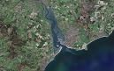
Exmouth and River Exe (including Topsham and Exeter Canal)
Your Comments: 16 Read or add your comments
Courtesy Flag
Flag, Red EnsignWaypoint
Safe Offing: 50:35'.5N 003:24'.0WCharts
Admiralty 2290, SC5601 SC5903 SC5914Rules & Regulations
10 Knts Speed LimitHazards
Approach Dangerous in strong onshore winds /swell, large drying areas inside, strong tidal streams within.Tidal Data Times & Range
HW Dover -0455 MHWS 4.6m MHWN 3.4m MLWN 1.7m MLWS 0.5m (Topsham HW +20min Exmouth) (links)This site is designed for slower, roaming broadband connections, like you would get at sea, so it needs JavaScript enabled to expand the text.
General Description
Contacts Harbour Masters Office 01395 223265 or 07864 958658
VHF 12 (C/S Exeter Port Authority)
Exmouth Marina 01395 269324 VHF 14 (C/S Exmouth Dock)
... read more
Approach
It is inadvisable to approach the area with onshore winds from the East, right through to the South West. ... read more
Berthing, Mooring & Anchoring
There are various mooring options around Exmouth, Starcross, Topsham and the Exeter Canal. There are various options offered by the local authority along with package deals for locking into and out of the canal at the Turf Lock -you can find details of this at ... read more
Your Ratings & Comments
16 comments
2024 charges
Written by Orwellian | 28th May 2024
Now £55 for a 10m visitor in the summer! Quite a hike on 2022 (doubled)......
Update April 2022
Written by Don Thomson 3 | 12th Apr 2022
I reviewed these notes in the spring of 2022. I think that the people in this area have upped their game a bit since the early comments made below six years ago. Certainly Exmouth marina is a better option than it used to be but the activities in the approach channel should be born in mind. I've adjusted the prices but there are so many variables they could be a mis-interpretation on my part.
1 of 1 people found this helpful
UPDATE SPRING 2021
Written by Don Thomson 3 | 30th Mar 2021
I reviewed these notes at the end of March 2021. Exmouth Dock has been partially dredged. The No 23 buoy has been found (!!) . There are warnings that depths may be a bit less over the bar at the beginning of the entry channel so err on the side of caution. Prices have changed across the board except Exmouth Marina.
Topsham - worth a visit
Written by Tyro Sailor | 27th Mar 2021
Three visits in 2018/19
Lots of tidal stream in the entrance, from the landfall buoy onwards, and especially in the region of Warren Point. If you're going up the river you want it flooding of course, but not too fast as it'll be a bit of a roller coaster. The moorings, of which there are many, would probably be a good place to practise ferry gliding!
Last time I visited I arrived from Brixham at low water and followed the flood all the way up to Trout's yard at Topsham where there's a barely-drying pontoon. The channel is well-marked for the most part, except that buoy no.23 was there, but a green can in 2019. Yes. Not a red can, or a green cone. Watch the echosounder like a hawk. I hit the putty only once, with a three-foot draught. Up at the town the channel is not as clear; I left the last lot of moored boats to port and came to no harm.
Trout's have a single loo available, and a well-stocked chandlery. Mark Trout is helpful and might leave you an electronic fob to get you in and out of the yard when he's gone home. Otherwise you might try the adjacent Sailing Club, bearing in mind that their pontoon is theoretically for dinghies only, especially on Wednesday evenings when their races are held. Good cheap home-made meals in the pleasant bar at that time. One or two dedicated visitors' buoys 20 yards off.
Lovely little town with proper shops including a nearby Co-op for victuals and an art shop where I was able to buy a violet pen for correcting charts. And famously, lots of pubs, one of which will serve you their many beers in 1/3 pint glasses so you can try several without falling over. Recommended.
1 of 1 people found this helpful
Exeter Ship Canal trip - October 2018
Written by Soolin | 14th Oct 2018
My friends and I enjoyed a lovely trip from Turf Lock to Exeter, overnight in Exeter Basin and back down again the following day, at the beginning of October.
It is not cheap but if you organise a few boats to go and split the cost, it is OK. And, when you see what you get for your money, you realise that it is not really that expensive. The canal chaps accompany you all the way, by road, open all the bridges and operate the locks. This is for two days. And then, the Countess Wear Road Bridge is opened and all the traffic held up just for you! It is definitely worth the money.
Fortunately, the weather was on our side which made it a glorious trip.
My only gripe is the lack of facilities when you get to Exeter - however, I can't see they can spend thousands on state of the art shower and toilet blocks if nobody uses it.
The canal chaps were so helpful and friendly and played a very large part in the enjoyment of our escapade. The lady at the canal office was similarly helpful and friendly when I was trying to organise it.
If you live locally, and own a boat, I would highly recommend doing this.
1 of 1 people found this helpful
UPDATE SPRING 2018
Written by Don Thomson | 27th Apr 2018
These notes were reviewed by Don in April 2018. Note the depth restrictions in Exmouth Dock Marina. We've checked with Tony Smith who is responsible for the buoyage and have been told it is unchanged since the winter. Prices have been updated. Contact has been made with the Watertaxi who is starting his 2nd season; they now have a website and sound ok
New Exmouth Water Taxi
Written by Bryant | 31st May 2017
"The new owners of the water taxis would like to let you know the River Exe is very much the place to visit.
Visitors moorings available all states of tide. Frequent taxis to and from the shore. Nice new wide slipway for easy launching.
Call 07970918418 for more information. "
Visitors moorings available all states of tide. Frequent taxis to and from the shore. Nice new wide slipway for easy launching.
Call 07970918418 for more information. "
1 of 1 people found this helpful
The ex river and canal to visit!!
Written by Harding | 20th Aug 2016
Please!! If your sailing around our beautiful Devon coast, give the ex river and the ship canal visiting moorings a miss!! Council are completely useless at operating a visiting boat, book to go in the turf lock and it will cost you £50!!!! One way, once you arrive you get dodgy old pontoons with a trickling tap on the side of a old shed that houses a filthy dangerous shower round the back!! Electric is by way of card and its all out of date boxes and rubbish. The canal men are miserable sarcastic and useless. Maybe they should get another job!! The turfs in a lovely spot but over priced, food and beer aimed at the rich and barstaff are a joke. Academics with no idea. Park your car to unload/load your boat and you get a idiot giving you a ticket!!! Exeter council again!!! Ferry to topsham from turf only runs till around 3pm so that's useless as well for boaters wishing to have dinner and get back to turf lock.
So to the quay you can moor up and again, facilities are horrendous, pub on the quay is overpriced and boring.
It was the worst 2 nights we had and Lyme Regis is just 100000000% better.
A lot of boaters I know have said the same but until you see it for yourself how bad it is then take my advise and give the ex and the canal a very VERY Wide berth!!!!
1 of 2 people found this helpful
Exeter Canal Office
Written by Simon J D | 14th Jul 2016
The telephone number for Exeter Canal Office has changed. It is now 01392 265791 and is answered on Mon, Tue, Wed and Fri between 09:30 and 14:30 only. The out of hours emergency number is 0845 3511060.
Update Spring 2016
Written by dononshytalk | 3rd May 2016
These notes were reviewed by Don in May 2016. We have added a link to a local survey of the approach. Your attention is drawn to our member's experience below.
View all 16 feedback items

© visitMyHarbour.com | website design created by Black Culm Ltd