

Harbour Information (use the  icons to find out more)


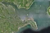
Falmouth 1, approach, entry, Inner Harbour, Penryn River
Your Comments: 15 Read or add your comments
Courtesy Flag
Flag, Red EnsignWaypoint
Black Rock R.Can 50:08'.68N 05:01'.74WCharts
Admiralty, 32, 154, 18, SC5602 SC5904 SC5912Rules & Regulations
Inner Harbour 6 Knts, minimal wash. Restronguet/Mylor/Percuil..5KntsHazards
Black Rock, St. Mawes Buoy / Lugo Rock...Busy Commercial Port, Upper Reaches Dry.Tidal Data Times & Range
HW Dover -6.10 MHWS 5.3m MHWN 4.2m MLWN 1.9m MLWS 0.6m (links)This site is designed for slower, roaming broadband connections, like you would get at sea, so it needs JavaScript enabled to expand the text.
General Description
Falmouth is a fine deepwater natural harbour of some considerable size. ... read more
Berthing, Mooring & Anchoring
In the area covered there are a few choices for mooring up, ... read more
Your Ratings & Comments
15 comments
Stayed for one night last week.
Written by Chris99 | 29th Apr 2024
We paid £44.63 for a 10.5m boat with electricity.
On approach, we tried Pendennis marina but they really didn't seem interested in us for some reason. Then tried Falmouth Haven and they were out of diesel and the office was about to close so we pressed on to Falmouth Marina. Filled up with diesel on the way in.
Staff were helpful although it took a few tries to pay as the night staff couldn't access the payment system.
Really nice facilities and the pub does very good food.
1 of 1 people found this helpful
Well Done FYB
Written by Tidal Tim | 3rd Sep 2022
We had a major VP2030 engine failure in July '22 which resulted in a new engine, gearbox, saildrive and folding prop. Jerry and the staff at Falmouth Yacht Brokers (Volvo agents) in Penryn were welcoming, knowledgeable, diligent and friendly. We had a haul out, engine etc. removal & replacement and back in the water within a fortnight. Can't recommend them too highly!!
Falmouth Marina update
Written by Tyro Sailor | 30th Jul 2022
Spending a couple of nights there earlier this week we found some of the staff rather offhand and the fuel pontoon didn't open when they said they would. The heads remain clean and well-maintained but the showers have nowhere to put the soap and make the rest of the floor wet.
Good little laundrette: £6 for a wash and dry but they won't take cash for the tokens. Waste/recycling compound across the car park. Sainsbury's, I discovered, is closer than Lidl (but more expensive of course).
A swings and roundabouts sort of place.
Good little laundrette: £6 for a wash and dry but they won't take cash for the tokens. Waste/recycling compound across the car park. Sainsbury's, I discovered, is closer than Lidl (but more expensive of course).
A swings and roundabouts sort of place.
Re Penryn website
Written by Don Thomson 3 | 13th Apr 2022
Falmouth Marina has always been part of the "Truro" bailiwick - it's just the Cornish harbours website that is new
Update April 2022
Written by Don Thomson 3 | 13th Apr 2022
These notes were reviewed in the spring of 2022. This part of Falmouth has been well established for years so the only changes I can find are to prices. I've confirmed that the Fuel Barge over by Trefusis Point is no longer there.
New website
Written by channelman | 11th Apr 2021
Penryn is now managed by Cornwall Council Harbours Board. The website is www.cornwallharbours.co.uk
1 of 1 people found this helpful
UPDATE SPRING 2021
Written by Don Thomson 3 | 30th Mar 2021
I reviewed these notes at the end of March 2021. Everything is up to date, prices have gone up. I can't get any info on the Fuel barge "Ulster Industry" but suspect is no longer serves yachties. We've added a note re the Observatory/ Church Tower transit for identifying Falmouth Yacht Haven mentioned in the note below.
Marinas, feeding, chandlery 2019
Written by Tyro Sailor | 20th Mar 2021
The Haven is convenient but not entirely sheltered and the ablutions block is small and barely adequate with those intensely annoying movement-operated showers. Friendly staff but daytime only. Very close to The Chain Locker and The Front pubs, both of which have good beer and sometimes traditional live music - which may attract or repel you.
There are, according to the Pilot, leading marks for the entrance but the old observatory tower on the hill in transit with the church tower is a good deal more obvious. Otherwise the entrance is hard to spot beyond the many moored boats.
The Marina, further up the river, is tricky to get into (see instructions above) and further from the town but better appointed and little more expensive. NB the drying 'bar' (actually a redundant sewage pipe, I'm told) halfway across the marina. Lidl a moderate walk away out of town.
In search of sustenance after a long day at sea, I strolled to the yacht club and found it closed; the nearby pub/restaurant was too busy to serve me. I ended up back in the town centre and was on the point of committing myself to Wetherspoons when I noticed a Nepali restaurant nearby. Excellent choice, especially as they had an 'all you can eat' buffet on. I could scarcely walk back to the boat.
Despite its reputation as a yachtsman's town I was unable to find oil or fuel filters, or a fresh water pump. I had to go to Mylor.
UPDATE SPRING 2018
Written by Don Thomson | 30th Apr 2018
I've reviewed these notes and the only changes are to the tariffs in some of the facilities whilst Falmouth Marina is maintaining it's prices.
1 of 1 people found this helpful
Update 2017
Written by Don Thomson | 1st Feb 2017
The notes have been edited to take account of the newish name of Falmouth Haven (the erstwhile Visitors Yacht Haven)
View all 15 feedback items

© visitMyHarbour.com | website design created by Black Culm Ltd