

Harbour Information (use the  icons to find out more)


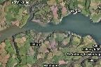
Helford River (to Gweek Quay)
Your Comments: 12 Read or add your comments
Courtesy Flag
Flag, Red EnsignWaypoint
Safe Offing: 50:05'.74N 005:04'.00W Voose N.Cardinal Buoy: 50:05'.81N 005:06'96WCharts
Admiralty 147 SC5603 SC5912Rules & Regulations
6 Knts, minimal wash in moorings, large areas of NO ANCHORING see textHazards
Gedges Rock, Car Croc Rocks, Voose Rock, Shallows and large drying areas in river. Pots and NetsTidal Data Times & Range
HW Dover -0615 MHWS 5.3m MHWN 4.2m MLWN 1.9m MLWS 0.6mThis site is designed for slower, roaming broadband connections, like you would get at sea, so it needs JavaScript enabled to expand the text.
General Description
Contacts
Helford Mooring Officer tel 01326 250749 VHF #37A (M1) ... read more
Approach
The River authorities have now supplied a video of the approach to their moorings which can be found at HERE ... read more
Berthing, Mooring & Anchoring
There are a couple of possibilities for anchoring just within the ... read more
Your Ratings & Comments
12 comments
UPDATE AUGUST 2022
Written by Don Thomson 3 | 23rd Aug 2022
We have just been informed that the garage at Gweek has closed so there is no petrol there; still a pub though!
Got the last mooring!
Written by Tyro Sailor | 2nd Aug 2022
Currently swinging on the last available visitors' buoy in the Helford River, having been directed here by a helpful and cheerful Moorings Officer. It's a big 'un, being intended for a 50' boat, with a correspondingly massive (and very clean) chain. £24 for the night for our Moody 346.
We looked for an anchorage further up the river but anywhere deep enough was either too exposed or marked as an oyster bed. I reckon they should get the oysters to sleep somewhere else.
We looked for an anchorage further up the river but anywhere deep enough was either too exposed or marked as an oyster bed. I reckon they should get the oysters to sleep somewhere else.
Update April 2022
Written by Don Thomson 3 | 21st Apr 2022
I reviewed these notes in April 2022. Prices are much the same as before but now £8 to use a Helford visitors mooring between 0800 and 1630. The special yellow makings for storage pots have been removed although you will come across normal pot buoys supporting storage pots in the area they were before.
UPDATE SPRING 2021
Written by Don Thomson 3 | 2nd Apr 2021
These notes were reviewed in April 2021. Prices have increased a little and all the hyperlinks have been updated.
I have approached the Port Navas Yacht Club for info on their facilities as it would appear that they would like visitors.
I have approached the Port Navas Yacht Club for info on their facilities as it would appear that they would like visitors.
Gweek Quay
Written by Tyro Sailor | 15th Mar 2021
I visited in the summer of 2019. The channel up to Gweek is very narrow, shallow and convoluted. Anything bigger than my Westerly Centaur (3 ft draught) would have trouble. I hit the putty on the way out.
There was room for one boat on the only pontoon, which was inadequately secured to the wall but did have fenders lashed along its outer edge.
Loos and showers at the other end of the boatyard, best described as primitive but usable.
Pleasant café with Wifi. Surprisingly well-stocked chandlery, who will accept your mooring fee but might not trouble to come out and collect it.
Upriver anchorage
Written by Kinvara | 3rd Jul 2020
If you have a fairly shallow draft boat (say 1m) and a misanthropic disposition there is a pool opposite Tremain Quay where you will stay afloat on most tides in near isolation. Easy landing on the Quay for a fair proportion of the tide or lie alongside the eastern wall if you want to dry out on a fairly firm bottom.
2 of 2 people found this helpful
Helford River Swinging mooring
Written by Collenan | 4th Sep 2019
We have rented a mooring for the summer from Helford River Moorings. Mooring Officer extremely helpful, even to checking the pick-up hasn't wrapped around the buoy when we are away from the mooring. Stunning place to base out boat on the south coast to start our adventure down here. other details accurate. Spring tidal flows are something to behold.
UPDATE SPRING 2018
Written by Don Thomson | 30th Apr 2018
Note ther new link to a video of the approach. Prices have increased.
June 2017
Written by JKEJ | 19th Jun 2017
Recently visited for the fist time this year to be faced with the rudest moorings officer I have ever met - Be warned!
1 of 1 people found this helpful
Update Spring 2016
Written by dononshytalk | 4th May 2016
These notes were reviewed by Don in May 2106. No changes apart from the tariff.
View all 12 feedback items

© visitMyHarbour.com | website design created by Black Culm Ltd