

Harbour Information (use the  icons to find out more)

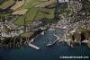
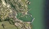
Mevagissey Harbour, and useful anchorages in St Austells and Mevagissey Bays
Your Comments: 9 Read or add your comments
Courtesy Flag
Flag, Red EnsignWaypoint
Safe Distance off Victoria Pier: 50:16'.2N 004:46'.80WCharts
Admiralty 147, 148, SC5602Rules & Regulations
5 Knts Outer Harbour and Approach, 3 Knts Inner Harbour.Hazards
Inner Harbour Dries, Dangerous to approach in onshore winds, Harbour Berths exposed in Easterly Gales, Black Rock off North Quay.Tidal Data Times & Range
HW Dover -0600 MHWS 5.5m MHWN 4.4m MLWN 2.2m MLWS 0.8m (links)This site is designed for slower, roaming broadband connections, like you would get at sea, so it needs JavaScript enabled to expand the text.
General Description
Contacts
Mevagissey Harbour Master tel 01726 843305 VHF #14 ... read more
Approach
Pilotage details: Straightforward enough, Gwineas Rock lies to the SSE and ... read more
Berthing, Mooring & Anchoring
In settled weather it is possible to anchor off the harbour, clear ... read more
Your Ratings & Comments
9 comments
Revised Yacht Moorings
Written by thefenderboss | 22nd May 2024
We visited on the boat in August 2023 and have visited by car since. What used to be two fore and aft trots, one either side of the entrance, has been reduced to one trot of about 5 or 6 on the port side as you enter. They seem close to the rocks and it is a bit tight when picking up the first and swinging towards the shore but pick up the windward buoy first and all should be fine.
Toilet and shower are basic but functional and the harbour staff very helpful
Toilet and shower are basic but functional and the harbour staff very helpful
1 of 1 people found this helpful
Mevagissey Facilities
Written by Mark Turner | 24th Jul 2022
In July 2022 the shower and toilet at the Harbour Master’s office were out of service. The public toilets in the village (50p) are locked between early evening and early morning.
Update April 2022
Written by Don Thomson 3 | 21st Apr 2022
No changes necessary
UPDATE SPRING 2021
Written by Don Thomson 3 | 6th Apr 2021
I reviewed these notes in April of 2021. The price has changed at Mevagissey but little else. Please note Conrad's comment below re beaching at Gorran Haven
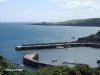
Goran Haven Beach
Written by Conrad ryle | 1st Aug 2018
The beach is small and very crowded in summer. Not really appropriate for bilge keelers, and the harbour master, a nice guy, would be quite put out. But anchoring outside is easy and the trip to the beach, where you should leave your tender to the east of the local moorings, is pleasant. The walk towards Dodman point takes you to Vault beach, a lovely place.
1 of 1 people found this helpful
UPDATE SPRING 2018
Written by Don Thomson | 30th Apr 2018
You may find evidence of storm damage here in the early summer but otherwise there doesn't seem to be much change here.
1 of 1 people found this helpful
Update Spring 2016
Written by dononshytalk | 4th May 2016
These notes were reviewed by Don in May 2016. There are, now, more visitors buoys in Mevagissey but their price remains unaltered. Note that they can no longer bunker leisure yachts with diesel. Charlestown has changed ownership but basically remains the same.
2 of 2 people found this helpful
Update 2014
Written by dononshytalk | 17th Mar 2014
Reviewed 2014 - harbour dues now £14 per night
1 of 1 people found this helpful
Update 2013
Written by dononshytalk | 30th Jan 2013
The Mevagissey harbour notes were updated by Don T on the 30th January 2013. The only change was the price of mooring in the harbour.
3 of 3 people found this helpful

© visitMyHarbour.com | website design created by Black Culm Ltd