

Harbour Information (use the  icons to find out more)

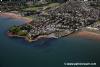
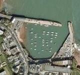
Paignton Harbour
Your Comments: 7 Read or add your comments
Courtesy Flag
Flag, Red EnsignWaypoint
Entrance 50:25'.95N 03:33'.35WCharts
Admiralty 26, SC5602 SC5903 SC5914Rules & Regulations
Dead Slow in entrance, Maximum size of boat 8.2m/27' Keep LEFT in harbour entranceHazards
THIS HARBOUR DRIES OUTTidal Data Times & Range
HW Dover-0500 MHWS 4.0m MLWS 0.7m MHWN 3.7m MLWN 2.00m (links)This site is designed for slower, roaming broadband connections, like you would get at sea, so it needs JavaScript enabled to expand the text.
General Description
Paignton was once a small commercial fishing harbour, but is ... read more
Approach
Locate Roundham Head, a low red cliff with white hotels, in the middle ... read more
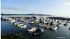
Berthing, Mooring & Anchoring
Anchoring is possible anywhere in the Torbay area in westerly winds, ... read more
Your Ratings & Comments
7 comments
Update April 2022
Written by Don Thomson 3 | 21st Apr 2022
No changes
Some excellent pubs and restaurants around the Harbour
Written by robinkm | 17th Aug 2021
A few good eateries now around the harbour, Tapas, fish and the new Harbour Light pub, (St Austell). Molly's, Crab & Hammer, TJ's (evenings) - A fair choice for lunch or dinner.
UPDATE SPRING 2021
Written by Don Thomson 3 | 6th Apr 2021
I reviewed these notes in April of 2021. They've got a new pontoon for visiting boats on the East Quay but I'm not sure whether you'd dry out on it. Prices have gone up and note that the toilets are locked at night.
UPDATE SPRING 2018
Written by Don Thomson | 30th Apr 2018
Tariffs are being held for this year; little else has changed
Update Spring 2016
Written by dononshytalk | 10th May 2016
These notes were reviewed by Don in May 2016. We note that there is now a pontoon alongside the East wall for visiting boats. Tariffs have been increased.
2 of 2 people found this helpful
Update March 2014
Written by dononshytalk | 18th Mar 2014
Reviewed March 2014. No changes and Harbour dues remain at £1.85m/day for a 10m boat for 2014
1 of 1 people found this helpful
Update 2013
Written by dononshytalk | 30th Jan 2013
Paignton Harbour notes were update by Don T on 30th January 2013 and the prices updated to cover the 2013 season.

© visitMyHarbour.com | website design created by Black Culm Ltd