
You are viewing the expanded version of this Marina,
for faster browsing
use the regular version here


Plymouth, Plymouth Sound, Anchorages and Central Marinas
Courtesy Flag
Flag, Red EnsignWaypoint
Draystone Buoy 50:18'.83N 004:11'00W Shagstone (safe distance off) 50:19'.05N 004:07'.70WCharts
Admiralty 30, 1967, 1900, 1901, 1902, 871, SC5602Rules & Regulations
10 knts in Plymouth Sound, 8 knts in Cattewater, 5 Knts Approaches to Marinas, Dead Slow within Marinas.Hazards
Busy Naval and Commercial port, see text for regulations. Strong tidal streams, Upper Reaches Dry.Tidal Data Times & Range
HW Dover-0540 MHWS 5.5m MHWN 4.4m MLWN 2.2m MLWS 0.8m (links)This site is designed for slower, roaming broadband connections, like you would get at sea, so it needs JavaScript enabled to expand the text.
General Description
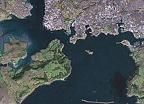
Plymouth is one of the finest deep water harbours in the country,
....although its sheer size makes it more suitable for big shipping than for yachts. Eddystone Rocks lay in the approaches at a good offing, and the details of the valliant efforts to build a durable lighthouse are covered in the history pages.
Plymouth is a busy naval and commercial port, and only in more recent times has it become popular for leisure craft. There are now four large centrally located marinas with excellent facilities for visitors, and several smaller marinas. Couple this with miles of navigable water in the rivers that flow into the main harbour, (with a multitude of anchoring opportunities), and you have an area that even deeper draft seagoing yachts could spend a good week exploring.
Nowadays Plymouth is an internationally renowned yachting centre and several major racing events are hosted here. Virtually all facilities can be found.
The main business of the city has been based around seapower and war since the days of Hawkins and Drake. Throughout two world wars up to the days of nuclear submarines patrolling the oceans, Plymouth has played a major role. The city was badly bombed by the Germans during World War II, and much of the city centre damaged. The Royal Marines have an important base here, and wherever you sail in this area will not escape naval activity.
The port is under the control of the Queens Harbourmaster, and warships have absolute right of way. Plymouth Sound itself is so large and deep that pleasure craft should have no trouble keeping out of the shipping channels, and thus out of trouble.
For the purposes of this guide, Plymouth has been divided into two sections:
1. Plymouth Sound, Anchorages and the central marinas (This page!)
Approach
Approaching from the West the visiting yachtsman or motorboater will pass.....
..... Rame Head and then Penlee Point, which has the Draystone Rocks extending for about a quarter of a mile to the SE. These are marked by the red can Draystone Buoy (Fl(2)R.5s), which should be left to port, although with a large scale chart safe passage can be made inside of this.
It should now be possible to see the conspicuous 19m white lighthouse (Iso.4s10M) that marks the western end of the very low lying breakwater, which is sometimes difficult to see. At night the light is visible from 031 degrees to 039 degrees True, and points the way for shipping from the Draystone Buoy, to the western entrance.
The central breakwater was completed in 1841, and transformed the open roadstead into a fleet anchorage. It is almost 1 mile long, took 29 years to build and landing on it is prohibited.
From the Draystone Buoy a Northerly course, with a touch of East, will bring the small craft towards the entrance and clear of shipping. At night the white sector of the Maker lighthouse ((Fl(2)WRG 10s 16m 11-6M) will help get you in. Note the red can buoy Queens Ground (Fl(2)R.10s), which the small craft can leave on the starboard side thus keeping out of the shipping channel. You are now in Plymouth Sound, expect to see anchored ships.
Further Pilotage Details:
When approaching from the East you will pass on your starboard side the Great Mewstone and the Shag Stone, (the latter being marked by an unlit white beacon). You should be aiming to keep East of the deepwater channel and its associated shipping. Be aware that the tide could be trying to set you to the East, and into danger. The deepwater shipping channel is bounded on the Western side by a shoal patch, marked on the eastern side by the East Tinker Cardinal buoy (Q(3)10s), and on the Western side by the West Tinker Cardinal buoy (VQ(9) 10s). Although this shoal has 3.5 m at CD, in strong southerlies seas can break heavily in this area, making the western entrance to Plymouth Sound a better option for small craft.
The eastern end of the breakwater is marked with a conical daymark topped by a beacon with the sectored light (L Fl WR 10s 9m 8/6M), one of the complex range of sectored lights to guide shipping using the eastern entrance. The narrow white sector from 353 degrees 001 degrees is used by shipping to help clear the Tinker shoal, and the Shagstone. The small craft should keep well to the shore side and will find themselves in the red sector of this particular light. The next point to make for is the westerly Cardinal beacon off Staddon Point (Q(9) 15s), leaving this to starboard. Ahead and slightly to the West, you will see a westerly Cardinal buoy, Duke Rock (VQ(9)10s), and this marks the edge of the shipping channel. Small craft can pass inside of this leaving it to port thus getting out of the way of shipping. You are now in Plymouth Sound, take note of the large Admiralty mooring buoys painted yellow and lit with flashing yellow lights.
Once inside the large expanse of Plymouth Sound one needs to decide which Marina or River to head for and further down we suggest some routing to avoid the big stuff in the main channels.
It is important to note that this port is under the control of the Queens Harbourmaster and all shipping movements are controlled from the Longroom, the tower west of the entrance to Millbay Docks. They are on VHF channel 16 and 14, callsign " Longroom port control". The following rule applies " all navigable waters north of 50° 20' (effectively the breakwater) shall be deemed a narrow channel. Vessels of less than 20 m in length, sailing vessels and vessels engaged in fishing shall not impede larger vessels manoeuvring within the port". Warships have right of way and should not be approached within 200 m when underway, and when crossing astern of them you must leave a gap of 800 m. They are normally accompanied by launches or RIBs of the MOD police who will quickly be on to you if you get in the way. Regarding the moored warships, you're not allowed to pass within 50 m of them, or within 100 m of berthed submarines.
Quite apart from the warships there is significant commercial traffic including ferries and it is wise to monitor VHF channel 14 while underway to keep aware of forthcoming shipping movements.
In actual practice there is plenty of water in most areas for small craft to keep well out of the way of big ship movements, by staying out of the deeper buoyed channels altogether. Below is a link to the Queens Harbourmaster's website:
http://www.royalnavy.mod.uk/qhm/plymouth
To get to any of the marinas, you will have to pass through one of four possible passages. There is a passage called the Bridge which lies to the west of the very conspicuous Drakes Island, (See charts and chartlets). If making for Hamoaze or Mayflower Marina and having entered Plymouth Sound via the western entrance, it makes sense to cut through here. The passage through the shallows is well marked by substantial lit beacons, and is likely to carry more than 1.3 m at LWS. Boats of normal draft can use this passage at any time other than dead low water springs, in reasonable weather.
Asia Pass carries over 5 m of water and is well marked by two red can buoys, Melampus (Fl.R.4s) and Asia (Fl(2).R.5s) on the western side. The eastern side is guarded by a southerly Cardinal buoy (Q(6)+LFl 15s) to the south and by a westerly Cardinal buoy (VQ(9)) to the North. For the average small craft there is plenty of water to keep out of Asia Pass proper, thus avoiding any shipping that could be using it, by skirting the two red can buoys on the wrong side. Consult the charts. This passage could be useful if you are coming from the West and making for Kings Point Marina, Sutton Harbour, Queen Annes Battery or Plymouth Yacht Haven. It could also be useful if you are coming from the East and making your way to the Hamoaze or Mayflower Marina, and don't want to use the Bridge.
The main channel called Smeaton Pass should be avoided if at all possible. It carries the deepest water and consequently is heavily used by shipping, and is well buoyed.
For craft entering Plymouth Sound by the eastern entrance and heading anywhere other than the Hamoaze or Mayflower Marina there is a good passage just to the east of the main Smeaton pass. Aim for the Mount Batten breakwater end (2FG (vert)), and pass between it and the southerly Cardinal buoy South Mallard (VQ(6)+LFl 10s) and the conical green buoy West Mallard (Q.G) lying a little to the NNW. There are minimum depths over the Mallard shoal of 3.6 m, and in anything other than exceptional conditions this passage is preferable to Smeaton Pass and its associated shipping.
Once through any of these passages be aware that you will be in the vicinity of ships using narrow buoyed channels, and you will be expected not to impede their progress. A good study of the charts is essential to understand the paths these ships are likely to follow, and a listening watch kept on VHF channel 14.
Berthing, Mooring & Anchoring
Just outside of Plymouth Sound to the West it possible to.....
.... anchor tucked deep into the Cawsand Bay Anchorage if the wind is in the West.
It has a gently shelving beach with good holding and has a surprising number of facilities ashore. There is a no anchoring area around Penlee Point and it stretches to the north-east into Cawsand Bay, so anchor off the town fairly close in. It is unwise to leave your boat unattended here in case the wind swings to the East, which makes this anchorage untenable, however if on passage westwards and not wanting to mess about going into Plymouth it is a useful stopping point. Cawsand can get crowded at weekends with local boats.
Ashore there is a shop in Kingsand which is open to 9 p.m. seven days, selling fresh veg, frozen meat and an off-licence. There is a small chandlers that doubles up as a post office in Kingsand also. Hungry sailors will find a good choice of takeaway food and assorted pubs and eating places. Land by dinghy on the beach.
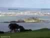
Inside Plymouth Sound anchorage can be found in Barn Pool, due West of Drake's Island. This is sheltered in most westerly weather but it is worth buoying your anchor as the bottom is foul in some places. This anchorage is preferable at neap tides, as getting ashore is easier in the dinghy.
North-east of the pier on Drake's Island is another option. Moorings in this vicinity belong to the Royal Marines. Beware of an underwater obstruction (0.9 m) 400 m due north of the pier.
It should be noted that Millbay Marina Village shown on the charts does not take visiting yachts, only residents. The five marinas with plenty of room for visiting yachts are now listed starting in the West with Mayflower International Marina, followed by King Point Marina, Queen Anne's Battery Marina, Sutton Harbour Marina, and Plymouth Yacht Haven. Full entry details and visitors prices are now provided:
Mayflower International Marina.
Mayflower Marina is located on the western side of Plymouth Sound at the mouth of the River Tamar. The marina has approximately 400 berths and is owned by a consortium of berth holders and has a quiet and friendly atmosphere. Visitors are most welcome.
Once in Plymouth Sound call Mayflower Marina on VHF Ch80 (24hours) or Tel: 01752 556633 (after hours 07840 116853).
Your approach to Mayflower Marina can be made either via The Bridge, or by following the Drake Channel. The shorter route is through the Bridge, which although well lit, is a fairly narrow channel and should only be attempted in favourable conditions. Least charted depth is 1.3m. It is considered advisable to motor through the Bridge due to strong tidal flows. To the east and west of The Bridge there are underwater obstructions.
Once through The Bridge, Mayflower Marina will start to appear on your starboard bow. The marina is protected by a heavy-duty floating breakwater with entrances at the Southern and Northern ends.
Marina staff are friendly and helpful and will usually offer berthing assistance to visitors and returning resident berth holders as a matter of routine.
Security is good and the marina offers comprehensive facilities including water, electricity and WiFi at all berths, diesel, petrol, Calor & camping gas, marine and electrical engineers, riggers a 33 tonne boat hoist and a 1.5 tonne crane. There is an excellent café bistro on the site called Jolly Jacks (Tel: 01752 500008), and a self-service launderette. The nearest supermarket is less than a mile away, the City Centre is approximately a 25 minute walk as is Plymouth Railway Station.

The overnight charges (2022) are £4.00 per metre, inc. VAT, but include shore power; short stays of up to 4 hours cost £5 for the first hour then £3 per hour affter that. There are deals available for longer stays and reciprocal berthing arrangements within the Trans Europe Marinas Group. The Marina can handle craft up to 25 m LOA, and larger craft can be handled by prior arrangement. A link to their website is below for further details:
http://www.mayflowermarina.co.uk/
King Point Marina
This Marina is run by Sutton Harbour marina and was opened in September 2013. It is entered via a wave gate at the NW side of Millbay Docks so basically enter between West Hoe Terrace and Eastern King Point, leave the private marina (Millbay Marina Village) to starboard and head for the back of Millbay Dock. The West side of Millbay Dock is the terminal for the Brittany Ferries Link with Roscoff; their main activity seems to be in the evening but you should exercise the usual caution if you sense any movement around that area.There is a standard set of passage signals on the port side of the entrance. They are on VHF 12 (c/s King Point Marina) and will direct you to a vacant pontoon berth. They share VHF 12 and a telephone number with Sutton Harbour Marina 01752 424297 so make sure that they know at the other end where you want to go. The Marina is not so central as Sutton Harbour's primary marina so they are charging (2022) £4.00 per metre per night for visiting boats but there are mid week discounts available You may choose to go to this marina or, if Sutton harbour Marina is full you may be directed to there. They have a full set of marina facilities including WiFi.

The area around the Marina is in the process of being "regenerated" so that ,as well as an on site restaurant facility, there may be an increasing number of eateries etc outside the marina but for 2018 that is still ongoing; there is already a licenced cafe/restaurant co-located here but that is just about all - it's about a mile to town.
The Marina website is at
http://www.kingpointmarina.co.uk/
Queen Anne's Battery Marina.
This is run by MDL, and was opened in 1986. As you approach you will see that this Marina is protected by a wall of piling. Leave this to your starboard side and follow in. There is a continuous pontoon running along the inside of the breakwater and this is where visitors are normally accommodated. The finger pontoons are for the permanent berth holders, but up to 40 visitors can be accommodated. In very busy periods you may have to raft up. Call them on VHF channel 80 callsign "Q.A.B", or call ahead on 01752 761142 to secure a berth.
Overnight charges (2022) are £4.20 per metre for boats up to 12.5 m, and £5.25 per metre for those up to 18 m.. rising again to £5.85 per metre for larger boats. These prices include electricity. Short stays are charged at £10.45 up to 15m and £15.40 for larger boats.
All the normal facilities are available here... water and electricity on the pontoons, WiFi Internet access, diesel and petrol from the fuel dock, showers, toilets and launderette. Calor and camping gas is available. A small shop selling provisions is on site, as is a bar/bistro. The Royal Western Yacht Club of England is based here, and visiting yachtsman are allowed to make use of its premises.
The club organises major yachting events such as around Britain and Ireland Race, Fastnet finish, and the OSTAR single-handed transatlantic race. QAB is of course very crowded during these big race events, and booking in advance will be essential.
Virtually all technical services are available from chandlery, charts agents, life raft repairs, stainless steel fabrication, diving, riggers. Additionally there is a 25 tonne travel lift and a large slipway.
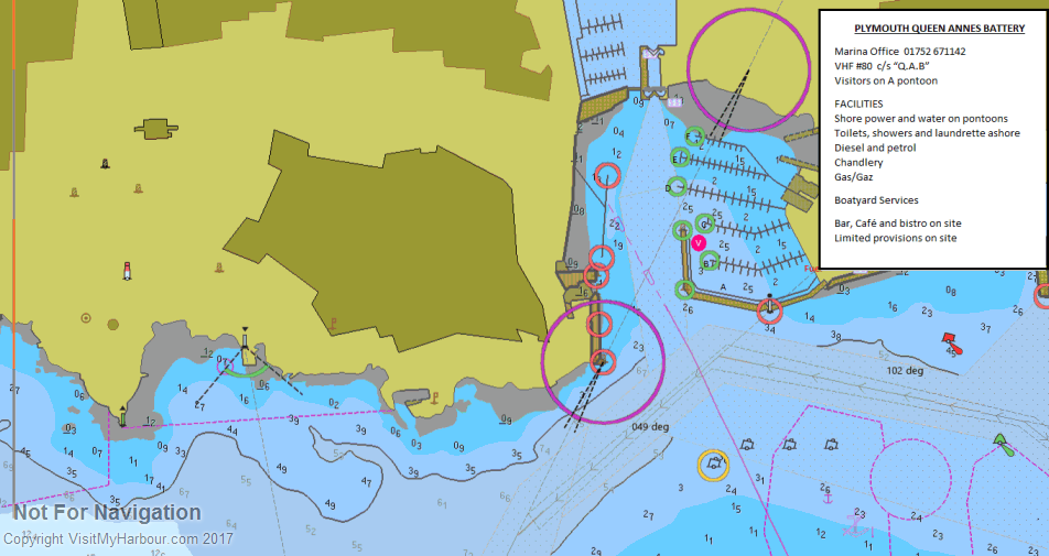
All in all virtually everything for yacht is available close by, but getting to the town centre itself can be a problem. It is not far via the Sutton Lock, but when this is open for shipping movements or closed to pedestrians (pedestrian access closed all night), you are faced with a long walk... not ideal when you've just had a skinful in the town, and you're trying to find your way back to the boat! The other problem is that the berths are distinctly uncomfortable in heavy weather from the southerly quadrant, in fact all the marinas in Plymouth except Sutton Harbour can suffer from surge and wash from shipping.
Link to the Marina website is below:
http://www.mdlmarinas.co.uk/mdl-queen-annes-battery
Sutton Harbour Marina
Sutton Marina lies immediately to the north of Queen Anne's Battery Marina, and is entered via a lock. Leave QAB on your starboard side, and the lock lies dead ahead, the approachs being dredged to 2 m. The lock is open for seaborne traffic day or night, 365 days a year, and shows standard traffic signals. Around the top of the tide all the gates are open for free flow, but the way for yachts may still be blocked by the footbridge. Call "Sutton Lock" on VHF channel 12, or telephone 01752 204732 before attempting to enter the lock.
Sutton Harbour Marina is virtually in the heart of the town, and because of the lock, can offer a peaceful berth, with no shipping and no surging whatever the weather. They are on VHF channel 12 callsign " Sutton Harbour Marina", telephone 01752 204702, and can accommodate up to 30 visitors, with a maximum length of 21 m. The Marina office overlooks the fuel pontoon at the end of Sutton Pier.
Overnight charges (2022) are based on LOA and season . Under 13.5m it's £4.40/m over 13.5m it's £4.85/m in high season. They do have special offers so it's worth checking their website
As you pass out of the lock into Sutton Harbour, the Marina lies dead ahead with the arrival berth clearly marked next to the fuel pontoon.

Facilities include water and electricity, showers, toilets, launderettes and 24-hour security. Diesel is available from 8:30 AM to 6:30 PM in the summer, but daylight hours only during the winter. Calor gas and camping gas are available and a chandlery is located on Sutton Pier beside the Marina. Nearby there are comprehensive boatyard facilities at Harbour Marine, with 25 tonne hoist, and full repair facilities. All the shops and facilities of the Barbican are just a short walk around the Quay.
Link to the Marina website below:
http://www.suttonharbourmarina.com/
Plymouth Yacht Haven.
Plymouth Yacht Haven opened in April 1998, and lies in Clovelly Bay, just to the east of Mount Batten. It is approached from the Cattewater, call " Plymouth Yacht Haven" on VHF channel 80 or telephone 01752 404231 for berthing instructions. Visitors may be berthed anywhere within the marina, follow directions from staff. Shelter is very good other than in strong north-easterlys, but it's location is nowhere near the city by foot or road although not far at all by water taxi (which runs from the Mountbatten Hotel steps. costs about £2.00 a trip and runs from 8am to10pm seven days a week in the summer). The Marina charges (2022) £4.20 per metre per night, with deals available for longer stays. Should you be moored near here we are told that you can land your dinghy on the town side at the slip at the Mayflower Sailing Club's slip opposite Queen Anne's Battery
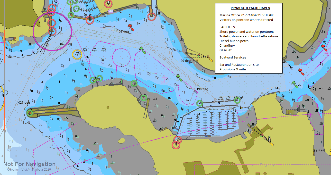
The 450 berth Marina can handle boats up to 20 m, and larger vessels by arrangement. All the usual facilities are available including showers and toilets, laundry, WiFi at the berths and an Internet cafe in the Marina itself. There is top class 24-hour security with coded access gates to the Marina.
Mount Batten Boathouse nearby is open six days a week (closed Sundays) and carries a large range of chandlery and Electronics. It also provides diesel from the fuel berth and can handle holding tank pump outs. Marine engineering and Electronics are available on site. A beefy 65 tonne travel lift is the largest in the area and there is plenty of laying up space and undercover storage. Other specialist contractors available include rigging, sail makers, boat repairs, stainless fabrication, and uphostery... all on-site.
Provisioning is now straightforward, with a shop at the Yacht Haven. For a serious stock up the nearest shopping centre, Plymstock, is a short bus ride away although there is a mini market at Hooe, a 10 minute walk away. There is now a bar/restaurant on site with other cafes close by. The Hotel Mount Batten Hotel has a restaurant and few minutes walk down the footpath brings you to the village of Turnchapel where the two pubs both serve food. A link to the Plymouth Yacht Haven new website is below:
http://www.yachthavens.com/plymouth
If you are not interested in the history and night life of central Plymouth there is everything that you need here for a couple of nights stop over on a cruise.
Facilities
Boat related facilities have already been covered to a certain extent with reference to the individual marinas.
The Plymouth area offers everything for the boat owner that can be imagined, from the building of a brand-new luxury yacht to replacing a defective shackle. A quick glance through the business directory will give you all the leads that you need.
For the trailer Sailer there are no less than 10 options for launching and recovery in the area and we list a few below:
Mount Batten Slip (01752 404567 Mount Batten Centre) offers a large concrete slipway with access at all of the tidal range except at dead low water springs. It is free. The nearby Mount Batten Centre is a charity organisation that encourages affordable watersports for all and has disabled access and disabled sailing and scuba-diving facilities.
Turnchapel Slip is West of Hooe Point sailing club on the South side of Cattewater and has access at about half of the tidal range. No charges.
Elphinstone Boat Park (01752 304304 landing officer) a concrete ramp next to the Plymouth harbour master's office, with access at all states of the tide. No charges.
The marinas also all have slipways available.
There are six yacht/sailing clubs in the area, all listed in the directory.
Plymouth obviously has plenty of banks with cashpoints and post offices, and for a good provisioning stock up there is a large Sainsbury supermarket in the older Armada shopping centre, which is however a taxi drive from the marinas.
There are good mainline railway links to the North and to London (08457 484950). The mainline station is slightly to the North of the city centre. Plymouth airport has flights to London, Scotland and Ireland (01752 204090) and there are straightforward road connections with the M5. International ferry connections to Roscoff and Santander (08705 360360).
History
Early history
Upper Palaeolithic deposits, including bones of Homo sapiens, have been found in local caves, and artifacts dating from the Bronze Age to the Middle Iron Age have been found at Mount Batten showing that it was one of the main trading ports of the country at that time. The settlement of Plympton, further up the River Plym than the current Plymouth, was also an early trading port, but the river soon silted up and forced the mariners and merchants to settle at the current day Barbican near the river mouth. At the time this village was called Sutton, meaning south town in Saxon.The name Plymouth, a back-formation from Plympton ("Plum-tree town"), was first mentioned in a Pipe Roll of 1211.
Early defence and Renaissance
During the Hundred Years' War a French attack (1340) burned a manor house and took some prisoners, but failed to get into the town. In 1403 the town was burned by Breton raiders. A series of fortifications were built in the Tudor and Elizabethan era, which include the four round towers featured on the city coat of arms; the remains of two of these can still be found at Mount Batten and at Sutton Pool below the Royal Citadel.
During the 16th century, Plymouth was the home port for successful maritime traders, among them Sir John Hawkins, who led England's first foray into the Atlantic slave trade, as well as Sir Francis Drake, who, according to legend, insisted on completing his game of bowls on the Hoe before engaging the Spanish Armada in 1588. During their time locally produced wool was the major export commodity. In 1620 the Pilgrim Fathers set sail for the New World from Plymouth, establishing the first colony of the United States of America.
During the English Civil War Plymouth sided with the Parliamentarians and was besieged for almost four years by the Royalists. Construction of the Royal Citadel began in 1665, after the Restoration; it was armed with cannon facing both out to sea and into the town, rumoured to be a reminder to residents not to oppose the Crown.
Rise of naval power
Throughout the 17th century Plymouth had gradually lost its pre-eminence as a trading port. By the mid-1600s commodities manufactured elsewhere in England cost too much to transport to Plymouth and the city had no means of processing sugar or tobacco imports, although it played a relatively small part in the Atlantic slave trade during the early 1700s. In 1690 the first Royal Dockyard opened on the banks of the Tamar and further docks were built in 1727, 1762 and 1793. In the 18th century new houses were built near the dock, called Plymouth Dock at the time, and a new town grew up. In 1712 there were 318 men employed and by 1733 it had grown to a population of 3,000 people.
Prior to the latter half of the 18th century grain, timber and then coal were the greatest imports. During this time the real source of wealth and the major employer in the region became the dockyard. The Three Towns enjoyed some prosperity during the late eighteenth and early nineteenth century and were enriched by a series of neo-classical urban developments designed by London architect John Foulston. Foulston was important for the town and was responsible for several grand public buildings, many now destroyed, including the Athenaeum, the Theatre Royal and Royal Hotel, and much of Union Street. Some of the greatest imports to Plymouth from the Americas and Europe during the latter half of the 19th cenury included maize, wheat, barley, sugar cane, guano, sodium nitrate and phosphate. Aside from the dockyard, other industries such as the gasworks, the railways and tramways and a number of small chemical works had begun to develop in the 19th century continuing into the 20th century.
Twentieth Century
The city was heavily bombed by the Germans during World War II in a series of 59 raids known as the Plymouth Blitz. Although the dockyards were the principal targets, much of the city centre and over 3,700 houses were completely destroyed and more than 1,000 civilians lost their lives. The redevelopment of the city was planned by Sir Patrick Abercrombie and by 1964 over 20,000 new homes had been built, but, despite this, in 1971 over ten percent of the houses in Plymouth were still occupied by more than one family. Devonport Dockyard was kept busy refitting aircraft carriers such as the Ark Royal. By the time this work ended in the late 1970s the nuclear submarine base was operational. The army had substantially left the city by 1971, with barracks pulled down in the 1960s, however the city has become home to more Royal Marines.
Stonehouse
East Stonehouse is one of three towns that were amalgamated into modern-day Plymouth.
West Stonehouse was a village that is within the current Mount Edgcumbe Country Park in Cornwall. It was destroyed by the French in 1350. The terminology used in this article refers to the settlement of East Stonehouse which is on the Devon side of the mouth of the Tamar estuary, and will be referred to as Stonehouse.
Settlement in the area goes back to Roman times and a house made of stone was believed to have stood near to Stonehouse Creek. However other stories relate to land owned in the 13th century by Robert the Bastard. This land subsequently passed to the Durnford family through marriage to the Edgecombe family in the 14th and 15th centuries.
During the 17th, 18th and 19th centuries the areas of Emma Place and Caroline Place were home to many of the west country's top-ranking admirals, doctors and clergy. Those streets together with Millbay Road are the heart of Plymouth's residual red light district. Union Street, originally built across marshland, was for almost a century the centre of the city's night life with about a hundred pubs, a music hall and many other attractions. Much of it was destroyed by bombing in World War II. After the war the area between Union Street and the dock has been used by small factories, storage, car dealers and repairers. Since 2002 many of those buildings and yards have been cleared and are being replaced by high density residential building.
Notable Buildings
Significant buildings include the Royal William Victualling Yard, the Royal Naval Hospital, Stonehouse and the Royal Marine Barracks. Of these three defence complexes only the Barracks remains in Naval possession, the other two were sold and are now converted to predominantly residential use.
During the reign of Henry VII defences at the mouth of the Tamar were strengthened by the building of cannon bearing towers. One of these, the Artillery Tower at the sea end of Durnford Street, has been preserved as a restaurant.
Two of the surviving buildings close to the dock at Millbay are the red brick Portland stone-faced Georgian assembly room that is still called the Long Room, and the exquisite late Georgian or early Victorian Globe Theatre 300m north within the RMB. These were built largely for the pleasures of the officer class and their gentry friends.
On the higher ground towards North Road are two major churches. Firstly the Anglican St Peter's with its tall spire in the centre of Georgian style Wyndham Square. A few hundred metres east is the late Victorian catholic cathedral. Both buildings have recently been restored with reordered interiors to meet modern liturgical preferences.
Regeneration
Gradually affluent residents are moving back into the district which has been comparatively poor since the Great War. Durnford Street is being regentrified. The walled enclosures of the Royal William Yard and the old Naval Hospital (known as the Millfields) are gated communities with security guards. The government's pressure to develop mixed quality high density dwellings on brownfield sites in inner cities has led to new residential blocks having been built throughout the area. Planned post war as a primarily commercial/industrial area it is now perceptibly changing its character. What was a dozen or so years ago viewed as one of the poorest and most deprived areas in north west Europe is fast losing that image.
On Stonehouse Creek, a branch of the Tamar, off the estuary known as the Hamoaze are the modern shipbuilding sheds occupied by the luxury motor-yacht firm Princess Yachts who employ hundreds of local tradesmen to construct and fit out expensive vessels. The creek now ends at Stonehouse Bridge (for many years a toll bridge) and to the north east the wide river bed which led up past Millbridge to Pennycomequick and beyond to the bottom of Ford Park Cemetery, has been reclaimed and infilled to provide the playing fields of Victoria Park, rugby pitches for Devonport High School for Boys, and nearest the bridge a large hardstanding used several days a week for Plymouth's biggest car boot sales. To the north is the main campus of what was Plymouth College of Further Education, now called City College.
Stonehouse is the site of Plymouth's international ferry port at Millbay Docks with at least daily sailings to Roscoff in Brittany and frequent ferries to Santander in northern Spain. Until the 1950s transatlantic liners would offload passengers who wished to catch a fast train to London rather than spend another day onboard going up Channel.
There is a regular passenger ferry from the tidal landing Admiral's Hard to Cremyll in Cornwall which is used for visitors to the Mount Edgcumbe Country Park, and commuters to Plymouth.
The Eddystone Lighthouse
Eddystone Lighthouse is on the treacherous Eddystone Rocks, 9 statute miles (14 kilometres) south west of Rame Head, United Kingdom. While Rame Head is in Cornwall, the rocks are in Devon.
The current structure is the fourth lighthouse to be built on the site. The first and second were destroyed. The third, also known as Smeaton's Tower, is the best known because of its influence on lighthouse design and its importance in the development of concrete for building . Its upper portions have been re-erected in Plymouth as a monument.
Winstanley's lighthouse
Winstanley's lighthouseThe first lighthouse on Eddystone Rocks was an octagonal wooden structure built by Henry Winstanley. Construction started in 1696 and the light was lit on 14 November 1698. During construction, a French privateer took Winstanley prisoner, causing Louis XIV to order his release with the words "France is at war with England, not with humanity".
The lighthouse survived its first winter but was in need of repair. The top was replaced, which causes some sources to state there have been five lighthouses on Eddystone Rock. Winstanley's tower lasted until the Great Storm of 1703 erased almost all trace on 27 November. Winstanley was on the lighthouse, completing additions to the structure. No trace was found of him.
The cost of construction and five years' maintenance totalled £7,814 7s.6d, during which time dues totalling £4,721 19s.3d had been collected at 1d per ton from passing vessels.
Rudyard's lighthouse
Following the destruction of the first lighthouse, a Captain Lovett acquired the lease of the rock, and by Act of Parliament was allowed to charge passing ships a toll of 1d per ton. He commissioned John Rudyard (or Rudyerd) to design the new lighthouse, built as a conical wooden structure around a core of brick and concrete and first lit in 1709. This proved more durable, surviving nearly 50 years.
On the night of December 2, 1755, the top of the lantern caught fire, probably through a spark from one of the candles used to illuminate the light. The three keepers threw water upwards from a bucket but were driven on to the rock as the tower burnt down. They were rescued by boat. Henry Hall, who was 84 or 94 at the time, died from lead poisoning because of the molten lead from the lantern roof he had ingested fighting the fire. A report on this case of lead poisoning was submitted to the Royal Society by the physician Dr Edmund Spry, and the piece of lead is now in the collections of the National Museums of Scotland.
Smeaton's Lighthouse
The third lighthouse marked a major step forward in the design of such structures.
Recommended by the Royal Society, civil engineer John Smeaton modelled the shape on an oak tree, built of granite blocks. He pioneered 'hydraulic lime', a concrete that will set under water, and developed a technique of securing the granite blocks using dovetail joints and marble dowels. Construction started in 1756 at Millbay and the light was first lit on 16 October 1759.
Smeaton's lighthouse was 59 feet (18 m) high and had a diameter at the base of 26 feet (8 m) and at the top of 17 feet (5 m). It remained in use until 1877 when it was discovered that the rocks upon which it stood were eroded—each time a large wave hit the lighthouse it would shake from side to side. Smeaton's lighthouse was rebuilt on Plymouth Hoe, in Plymouth, as a memorial.
The foundations and stub of the tower remain, close to the new and more solid foundations of the current lighthouse - the foundations proved too strong to be dismantled so the Victorians left them where they stood.
Douglass's lighthouse
The current, fourth, lighthouse was designed by James Douglass, using Robert Stevenson's developments of Smeaton's techniques. The light was lit in 1882 and is still in use. It is operated by Trinity House. It was automated in 1982, the first Trinity House lighthouse to be converted. The tower has been changed by construction of a helipad above the lantern, to allow maintenance crews access.
The tower is 49 metres(161 ft) high, and its white light flashes twice every 10 seconds. The light is visible to 22 nautical miles (41 kilometres), and is supplemented by a fog signal of 3 blasts every 60 seconds.
The text on this HISTORY page is covered by the following licence
http://en.wikipedia.org/wiki/Wikipedia:Text_of_the_GNU_Free_Documentation_License
Eating, Drinking & Entertainment
As is to be expected in the city of this size there are almost endless choices of things to do and see. From museums and art galleries to ice skating and 10 pin bowling, multiscreen cinemas and the theatre.
Shopaholics will soon make a beeline for the new Drake's Circus shopping centre in the heart of the town, which houses Marks & Spencer's and Boots amongst many others.
Absolutely all kinds of pubs and restaurants are available, and as in many seafaring towns there is a very vibrant nightlife scene on Fridays and Saturdays, with the epicentre near the Barbican, very close to Sutton Harbour. I'm afraid that all of Jolly Jack's favourites have gone the GX, Boobs, Diamond Lil's and the Brown Bear - all gone.
Some links are provided below for further investigation:
General Info
http://www.visitplymouth.co.uk/
Leisure
Visitors and tourism | PLYMOUTH.GOV.UK
Pubs
http://www.beerintheevening.com/pubs/results.shtml/el/Plymouth%3BDevon/
Eating Out
Restaurants & Places to Eat in Plymouth 2021 - Tripadvisor
Nightclubs
http://www.touchlocal.com/nat/c-1355-t-19415-Night+Clubs-Plymouth
Links
|

Your Ratings & Comments
We wanted to fill up with diesel in the morning, but there would have been a long wait. For some reason one boat had been at the pontoon for over an hour with another trawler/pilot boat waiting so we didn't bother.
An impressive place, just around the corner from the Royal Navy yards and across from the old victualling yards (now "luxury flats" apparently).
There are 2 toilet blocks, one is old and being refurbished (and needs it!) and the other - on the right with a blue awning - is brand new and very good.
On site pub is ok but I think you should book in summer months as it gets quite busy.
QAB is decidedly bouncy in a southerly wind, the so-called breakwater failing to live up to its name, and a two-mile fetch from the main breakwater.
View all 13 feedback items