
You are viewing the expanded version of this Harbour,
for faster browsing
use the regular version here

Poole Harbour, Approach and Entrance, Anchorages at Studland Bay and South Deep
Courtesy Flag
Flag, Red EnsignWaypoint
Safe Offing for Swashway Channel (see chart) 50:39'.06N 001:54'.85WCharts
Admiralty 2611, SC5601Rules & Regulations
6 Knts within 200m of BeachHazards
Old Harry Race, Strong Tidal Stream in Harbour Entrance, Chain Ferry, ShippingTidal Data Times & Range
HW cannot be related to Dover,. MHWS 2.00m MHWN 1.6m MLWN 1.1m MLWS 0.3m. See tide tables- (links)This site is designed for slower, roaming broadband connections, like you would get at sea, so it needs JavaScript enabled to expand the text.
General Description
The Sandbanks Yacht Company sponsor this page...
Poole itself is a huge natural harbour, much of it shallow with several.......
......... deepwater channels leading to the town and the numerous marinas and small boat facilities. It supports a veritable armada of small craft and virtually every support service for the boat owner will be found within.
It has very unusual tides, in that it has a very small range with a stand of a couple of hours at high water. During this stand a secondary movement can take place with a dip and a rise, more pronounced at Springs and almost unnoticeable at neaps.
It is worth noting that there is a very small range in the tides; springs have a range of about 1.8m with HW of just over 2m and at neaps it's sometimes less than a metre with a HW of 1.8m so the shallows on the chart remain that (shallow!!) even at HW springs.
In spite of the small range, the vast volume of water flowing in and out of the narrow entrance can produce tidal streams of approaching 5 kn on the ebb, and the Mariner needs to consult the tide tables and time his entry accordingly.
Frequent ferries use the harbour including fast cats, and a good lookout ahead and astern is mandatory when using the main channel. Other than the entrance itself the main channel can be avoided by using secondary channels with adequate depth for all small craft.
In the approach to Poole on the Western side lies Studland Bay, which can provide a good anchorage, well protected from a westerly quadrant. This is extremely popular with leisure boaters during the summer.
Within the harbour a good anchorage can be found in South Deep, and this particular article deals with the approach and entrance to Poole, the above-mentioned South deep anchorage inside, and the Studland Bay area. Further articles deal with the North side of Poole Harbour (including the marinas and small boat facilities) and also the River Frome to Wareham.
For those light on pocket these anchorages are free, in contrast to the rather heavy charges encountered at all the Poole marinas. The harbour authority does have the right to collect harbour dues from all users of the harbour, and we have been informed (by them) that they have tightened up on this aspect. They say they have up to four or five boats patrolling the harbour at any one time on the look out for boats not showing dues paid decals and have provided a facilty on their website for on-line payment of £0.65/pm/pd. See below
Approach
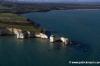
From the South identify Handfast Point, and it's attached Old Harry Rocks (see photo gallery)......
...... Give this a good offing as there is a tidal race on the ebb that extends outwards for a good distance. From the East the high cliffs of Anvil Point will be seen from a distance, and closer in the rocks of Old Harry. Still closer in the buoyage will be seen of the Swash Channel. Aiming for Handfast Point and the Old Harry Rocks will keep you away from the Hook Sands.
The main Swash Channel into Poole is well marked and is usable day and night in all conditions. It is worth noting however that in very strong winds from the South or Southeast it can become dangerous on the ebb in the vicinity of Poole Bar. The channel itself runs between a training bank on the Western side and Hook Sands on the eastern side.
Further Pilotage Directions...
A small boat channel exists just to the Western side of the Swash Channel, and is the recommended entrance for small craft, as it will keep you out of the way of ferries. It is marked on its western side by a series of lit and unlit red piles on the training wall, and bounded on the Western side by the red can buoys of the Swash Channel proper. It is clearly marked on our charts and if using this channel it is necessary to rejoin the Swash Channel after passing the red can buoy number 8 (which will be on your starboard hand) and before you reach the red can buoy number 10, which needs to be left to port.
Another approach channel if coming from the East is the East Looe channel which involves an approach towards Sandbanks and picking up the buoyage that first leads in an westerly direction and then a south westerly direction skirting the beach closely. There is not much water in this approach and calm conditions with a suitable rise of tide will be required. Care will also be required to make sure that you pick the buoyage up before running on to Hook Sands. From a distance off keeping the conspicuous hotel at Sandbanks on a bearing of around 260° will guide you to the buoyage. The proximity to the beach and the shallow depths make this an uncomfortable option for some, in which case the main Swash Channel is an easy option. The East Looe channel is however the most direct option for those heading for the Solent, and somehow always seems easier to use when leaving Poole than when approaching.
If using the main Swash Channel it is simply a matter of following the buoyage from the start and keeping a good eye out for fast ferry traffic.
Whichever channel you use they all lead to the narrow entrance with the chain ferry plying its way back and forth.
The tides can run extremely hard on the ebb, sometimes approaching 5 kn at Springs and great care must be exercised in the vicinity of the chain ferry which should always be passed astern. It is seamanlike to use your engine and not attempt to sail this busy entrance. It is not unknown for engineless boats to be pinned onto the Chain Ferry by the ebb, and in one instance I recall a racing dinghy was swept on to, pinned against and eventually forced underneath the Ferry and was lost. The lone helmswoman also was swept clean underneath the Ferry, but happily popped up the other side unhurt. Her would-be rescuers in a large inflatable very nearly suffered the same fate....
Once past the chain ferry you are in Poole Harbour properly. Hondula !
Berthing, Mooring & Anchoring
Studland Bay provides good shelter in westerly winds and has good holding ground.
The whole area is heaving with anchored boats during the season, the beach is pretty and has an area set aside for nudists. The area is under the control of the National Trust and ashore there is a cafe and toilets. There is a 6 kn speed limit within 200 m of the beach.
Update 2022. We have been advised by DEFRA that there has been no shift in the policy here and that although there are no legal restrictions on anchoring in Studland Bay the Marine Management Organisation (MMO) has established a Voluntary No Anchoring Zone in Studland Bay the limits of which can be found in their leaflet of this year. Basically it tells you where the eel grass and sea horses are and asks that you don't anchor on top of them.
The MMO Leaflet can be found at
Studland Leaflet (publishing.service.gov.uk)
Our research has also discovered that the "Boatfolk" organisation (they also run eleven marinas) is involved with the provision of "eco-moorings" and have already installed ten such buoys which are free to use. So, basically, if you intend using Studland Bay, you must take care to stay up-to-date with developments there and be very, very careful where you put down an anchor.
If arriving from the South be aware of the tidal race on the ebb off Old Harry Rocks, and stand-off to avoid it. Then it is just a matter of tucking yourself in and anchoring to suit draft. No facilities for the boat, but there is a slipway with access at about a quarter of the tidal range, boats of over 20 hp are not allowed here. Telephone 01929 450259 for details.
Inshore about a quarter of a mile away is the village where limited provisioning can be accomplished.
For yachtsmen or motorboaters looking for a "bombproof" anchorage, pilotage directions are now given for South Deep within Poole Harbour..
On entering Poole Harbour it is possible to anchor in South Deep which lies on the opposite side of the sand spit, and offers shelter in all directions. Follow the directions already provided for entering Poole and only make your turn to port after you have passed the red can buoy number 14 (Fl.R.2s) and the black and yellow northerly cardinal Marker (Q.Fl).
The banks and the buoyage in this area have changed in recent years, and not as much water is available as shown on earlier charts. Swinging on to a south westerly course pick up the posts and buoyage marking South Deep, and work your way in. There is a least depth of 1 m for a short while before it deepens out again. The channel markers are well lit in the first part of South Deep, and it is in steady use by a large flat bottomed barge that services the BP oil rigs on Furzey Island. (See photo gallery), as well as assorted tripper boats.
Anchorage is possible anywhere in South Deep, shellfish beds are well marked and in the region of Furzey Island power cables cross the channel and anchoring is prohibited. These are charted and there are noticeboards.
It is possible to carry deepwater right through the bight below Green Island and the channel is marked by buoys or posts. Once past Furzey Island you won't have the passing barge to contend with, but the channel is narrow and deep. Anchorage is possible wherever you can find space.
The mud of South Deep offers good holding but can make a real smelly mess when you retrieve the anchor. The intrepid shoal draft cruiser can circumnavigate Brownsea Island, and those seeking peace and quiet can find some in this area although the oil rigs impinge on the scene. As usual careful attention to the charts and nosing in on a rising tide is the seamanlike way to go about things.
The only boat facility in the immediate area is the Shell Bay Boatyard at Studland,(just inside the entrance to Poole Harbour) which can offer moorings, swinging moorings (£20 a night), and some boatyard facilities. Launching and recovery is possible here at three quarters of the tidal range, with a freshwater tap at the slip. Contact the boatyard (Rob Hewer) for details 01929 450340 or 07834 492987. Website:
Limited provisions ashore at the village mentioned above.
Just inside Poole Harbour to the N of the entrance, Sandbanks Yacht Company have visitors moorings and a club, see the "More Info" section
Finally a word from the Harbour Authority about the Southern Harbour Area :
"There is an existing quiet zone lying to the south of a line from Patchins Point to South Haven Point where there is an advisory speed limit of 6 knots. (Patchins Point is about 3 miles WNW of South Haven point so we're talking the whole of the drying area to the South & West of brownsea island) This area allows yachtsmen and other recreationalists a quiet anchorage in which to enjoy the beauty of the southern harbour without the bustle associated with the northern channels.
The provision of this quiet area has helped to reduce adverse impacts on the flora and fauna of the undeveloped mudflats and shallow inlets which characterise much of the southern shores. Many of the redshanks which nest in Poole Harbour do so in the saltmarsh of this area. The Quiet Area is a ‘safe haven’ for birds and wildlife as well as for humans. It is intended to maintain the current policy against changes in land use and excessive recreational activity. Personal Watercraft have their own area exempt from the speed limit and are not allowed in the quiet area."
Facilities
Nothing much in the way of facilities in the immediate area other than as mentioned above.
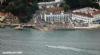
Just inside Poole Harbour to the N of the entrance, the long established Sandbanks Yacht Company has moorings..and a magnificent new clubhouse. Expand the "More Info" section
More Info
Just inside Poole Harbour...
Sandbanks Yacht Co have visitor moorings located alongside the North Channel, just before the RMYC Channel entrance. The Buoys are black in colour and marked with their logo. All moorings are suitable for boats up to 10m with moorings for larger boats by arrangement. They charge (2021) £20 for a 10 metre boat Call 01202 611262
All moorings are serviced by a club launch/taxi during opening hours. This does not cover the evening hours, so if coming ashore for the evening you will have to do so in your own dinghy and there will be a current moving through the moorings at half tide.
Sandbanks Yacht Company help sponsor our Poole coverage:
![]()
Sandbanks Yacht Co. welcomes you to our stunning Club, Café bar, Gym and Boatyard on the beautiful Sandbanks Peninsula. Redeveloped on the original Sandbanks Yacht Co. site established in 1957, the club retains its heritage whilst appealing to a wider audience.
http://sandbanksyachtcompany.com/
With water access, our state of the art gym, classes and treatment rooms, we really have got the art of good living covered and if all of that sounds like too much effort, you can kick back and watch the world go by in our Boatyard Café Bar! With a delicious menu, creative wine list and champagne by the glass, there really is no better place to relax and unwind.
History
Studland is a small village on the Isle of Purbeck in the English county of Dorset. It is famous for its beaches (named South Beach, Middle Beach and Knoll Beach) and Nature Reserve. In 2001 Studland had a population of 480, the lowest in 50 years. Many of the houses in the village have been bought up as holiday homes, second homes, or guest houses, and the village's population varies depending upon the season. The village is five miles (8 km) south of the conurbation of Poole and Bournemouth, but separated from it by Poole Harbour and the Sandbanks Ferry. The village is five miles (8 km) north of the town of Swanage, over a steep chalk ridge.
The bay is protected from the prevailing winds and storms by Old Harry Rocks, the chalk headland that separates Studland from Swanage bay. This has allowed, over a period of approximately 600 years, a sandy beach to be deposited against the reddened sandstone cliffs, at the south end of the bay, and the Reading and London clay formations at the north end of the bay. This deposition has led to the growth of a psammosere (sand dune system). The beach extends north, part way across the mouth of Poole harbour.
Behind the sand dunes there is a large area of heathland, called Studland heath, and Poole harbour. There is Little Sea, a fresh-water lake amongst the dunes which was cut off from the sea by the development of the dunes. The lake is a haven for birds and other wildlife.
To the West of Studland Bay, there is a large area of heathland known as Godlingston Heath. Standing on a mound in the heath is the 400 tonne, 17 ft (5.2 m) high Agglestone Rock; the local myth states that the devil threw it there from the Isle of Wight. In truth, it is more than likely part of a band of rocks that run across the whole of Godlingston Heath. The sandy earth was eroded around the firmer rock and left it standing proud. Other lumps in the landscape can be seen across the heath, including the Puckstone which, in years to come, may be another standing rock similar to the Agglestone.
The heath and harbour are home to Britain's largest onshore oil field, and BP's Wytch Farm refinery is hidden amongst a pine forest to the west of the heath. Studland and Godlingston heath have been a National Nature Reserve since 1946, and the site is on English Nature's list of "Spotlight Reserves", the 31 most important reserves in England. The site is also a protected Site of Special Scientific Interest, Area of Outstanding Natural Beauty, part of the Purbeck Heritage Coast, and a gateway to the Jurassic Coast World Heritage Site. The site is one of only a few places (mostly in Dorset) in Britain which is home to all six native reptile species. The site is owned and managed by the National Trust, who clear scrub, keep the beach tidy, and carefully manage the millions of visitors the site gets each summer.
The area is just across Poole Harbour from the conurbation of Poole, Bournemouth and Christchurch. The five-mile long beach is close enough to be convenient and accessible, but far enough to be free from the pollution and sewage associated with urban beaches. This and the careful management by the National Trust and calm shallow waters make it one of the most popular beaches in the country, and on hot summer weekends the beach fills up with thousands of people. The National Trust have restricted parking provision at the site to prevent overcrowding. A short northern stretch of the beach is reserved as a naturist beach.
The final stage of the South West Coast Path (if walked in the conventional anti-clockwise direction, starting at Minehead) follows Studland Bay and ends at South Haven Point, where a sculpture marks the end.
History
World War II
In 1940, the coastline at Studland Bay was one of the two stretches of Dorset coast where a German invasion was considered most likely and it was fortified as a part of British anti-invasion preparations of World War II.
The village and beach were used as a training area before the D-Day landing in the Second World War. On top of Redend point, a small sandstone cliff which splits the beach in two at high tide, is Fort Henry. Built in 1943 by Canadian engineers, it is 90 ft (27 m) long, with 3 ft (1 m) thick walls and an 80 ft (24 m) wide recessed observation slit. On April 18, 1944 King George VI, General Sir Bernard Montgomery, and General Dwight D. Eisenhower, met here to observe the training troops and discuss the plans for the coming battle.
Beach management
In January 2004 the BBC television series The National Trust investigated the conflicts between different groups of people who use the beach and heath at Studland. The series particularly covered the debate about coastal management at Studland. At present the cliffs and beach side shops are protected by rock walls (coastal defences). The National Trust proposes removing these defences to allow natural processes to shape the coastline. The popular Middle Beach Cafe which sits on the top of the rock gabions at the Southern end of Middle Beach will fall into the sea in the next ten years if the defences are left to nature.
The text on this HISTORY page is covered by the following licence
http://en.wikipedia.org/wiki/Wikipedia:Text_of_the_GNU_Free_Documentation_License
Eating, Drinking & Entertainment
Cafe on the beach at a Studland. Nearby, just inside Poole Harbour to the N of the entrance, the long established Sandbanks Yacht Company has a cafe, new clubhouse, and visitors moorings. Expand the "More Info" section to find out about this.
Virtually all facilities can be found deep in the North side of the harbour at Poole town.
Links
|

Your Ratings & Comments
https://www.rya.org.uk/news/engage-or-enrage-warns-rya-as-mmo-propose-no-anchoring-zones-in-studland-bay
And the official line is here
https://www.gov.uk/government/publications/marine-conservation-zones-studland-bay
***********
Thanks, Don, for re-posting my comments on anchoring inside the harbour in this more appropriate place. Off Goathorn Point is also good - I spent a quiet night there last year while a fresh sou-wester was blowing outside.
In a SWly head head up one of the channels to the west and drop the hook off Cleavel Point or somewhere similar, but make sure you won't swing into the channel. Everywhere, as far as I've discovered so far is fairly soft mud.
Wherever you go, make sure you get the tide right or you might find yourself stuck for a fortnight.