You are viewing the expanded version of this Harbour,
for faster browsing
use the regular version here


Yealm, River
Courtesy Flag
Flag, Red EnsignWaypoint
Safe Distance WP see chart 50:18'.591N 004:05'.00W Outer Red Buoy marking sandbar: 50:18'.59N 004:04'12WCharts
Admiralty 30, SC5602 SC5903 SC5904Rules & Regulations
6 Knts in river.....Enforced. Minimal WashHazards
Unlit Rocks in Approach from East and West, Sand Bar across entrance, Under 1.5m just inside at LWS. Entrance Unsafe in Heavy onshore winds .Tidal Data Times & Range
HW Dover-0520 MHWS 5.4m MHWN 4.3m MLWN 2.1m MLWS 0.7mThis site is designed for slower, roaming broadband connections, like you would get at sea, so it needs JavaScript enabled to expand the text.
General Description
Contacts
Harbour Master 01752 872533 NO VHF
The River Yealm is a small and beautiful haven that is tucked away behind a sand bar guarding the entrance. It is a bit off the beaten track for holidaymakers as there are no beaches, but gets very crowded with pleasure boats during the height of the season. Basic provisions are available ashore, but this is not the place to embark on repairs or to do a major stock up.
This cannot be considered a harbour of refuge, Plymouth to the West and Dartmouth to the East can be entered in all weathers.
In settled weather early or late in the season the River Yealm could well be worth a visit, but on busy holiday weekends it can get so overcrowded that the harbour authorities may turn boats away. Space available is very limited, anchoring is not allowed except just inside the entrance, and rafting up on the moorings is common.
The Yealm Harbour website can be found at
www.yealmharbourauthority.co.uk/#1
Approach
In strong onshore winds Wembury Bay can be very rough......
..... and it is unwise to attempt the entry. Make for Plymouth (preferably the western entrance).
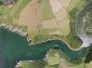
In normal conditions in spite of the sandbar, entrance is fairly straightforward. A good study of the charts will be necessary before making any approach as there are unmarked dangers in the offing.
Pilotage directions...
There is a good chartlet HERE of the layout of the River from the Bar inwards
To the south lay the unmarked Western Ebb Rocks and the Eastern Ebb Rocks, about half a mile off Gara Point. With any sea running they will reveal themselves by the breaking waves, but in flat calms they are just as dangerous but invisible. There is a conspicuous church tower, St. Werburgh's, shown on the chart and providing you keep this on a bearing of more than 5°T you will clear these rocks. To avoid all confusion probably the simplest solution (when starting from a good offing) is to approach the waypoint given on our chart when it bears NE. This will also keep you clear of the dangers in the Western approach, which will now be described.
The Great Mew Stone is an extremely conspicuous landmark to help you locate the entrance to the River when approaching from the West. It needs to be given a wide berth as there are outlying dangers two cables to the South West (Mewstone Ledge), and also the Inner and Outer Slimmers, hiding unmarked 2 Cables to the East of the island.
It should be noted before planning to enter that at LWS, there may only be 1.2 m of water in the channel between the Bar Buoy and Misery Point, and deeper draught vessels should time their entry accordingly.
The entrance to the River Yealm will not open up to view until you are abeam of Mouthstone Point, which has a rocky ledge extending one cable to the West. Try to pick up the leading marks, which are shown on the chart. They are two posts with white triangular top marks and a black vertical line. By putting these in-line one above the other, you will be on a transit of 88°T and this will help you clear Mouthstone Ledge. Move in on this transit, but be aware that the leading line does not clear the sandbar that almost blocks the entrance to the River. The southern tip of the sandbar is marked by the only lit buoy in the whole River,(the red can Bar Buoy (Fl.R.5s)). This needs to be identified and left on your port hand side. The channel is very narrow and sticking fairly close to the red buoy, and the next unlit red buoy lying slightly to the North and East will help you keep clear of the rocky foreshore. A green beacon roughly level with the second red buoy and on the southern shore helps identify the channel which normally has 3 m in it, but after this it shallows out rapidly.
Next a positive swing to the north-east is required to pick up the next beacon. It is located on a hillside about three cables eastwards of Season Point, and consists of a post with a white square board marked with a red vertical line. The direct line from the second red buoy towards this post will keep you in the deepest water. As you approach the Northern shore roughly abeam of Misery Point depths increase and you can swing to starboard and enter the River proper. The hard part is over. Pat on the back and a cigarette for the skipper (if he's that way inclined).
Berthing, Mooring & Anchoring
It is possible to anchor just inside the entrance of the bar at Cellar Bay,....
.... but the holding is indifferent, and it is totally exposed to the West and not really an option unless the wind is offshore.
It is however often used as a lunchtime stopover, there are no charges. Anchoring elsewhere is not allowed because of lack of space and further up the river, oyster beds...
The first visitors buoy you'll notice to port after passing Misery Point is allocated for heavier craft up to 25 m. Pushing on up the River keeping in the fairway between the moorings keep an eye out for a red can buoy marking a sand spit that grows out from Warren Point towards the SE, and extends about halfway across the river. Do not be tempted to pass this buoy on the northern side.
Opposite this narrow point two further heavyweight visitors mooring buoys can handle three boats at a time rafting up. The buoys are all clearly marked " Visitor". A little further on, on the eastern side, lies a visitors pontoon about 50 m long. Visiting boats are packed in here three abreast (when necessary) on the deep water side. The tide can set quite strongly onto this pontoon.
In 2022 they are charging £2.00 per metre wherever you stay with a week being charged as five days.
This area known as The Pool is virtually landlocked with steep to shores and gives perfect shelter from the sea, however in strong winds is subject to being whipped up by williwaws and gusts.
Further options...
Pushing northwards slightly the River divides with the Yealm continuing north and Newton Creek branching to the East. Newton Creek dries out totally, but continuing up the Yealm, you will come to another visitors pontoon on the Western side that can handle 20 boats rafted up.
As space is tight it is considered permissible to tie up to private moorings if they don't have a dinghy or a note attached. Obviously select a mooring suitable for the size of your boat, and do not leave your vessel unattended without clearing it first with the harbour authorities who may well know the owners plans. You must also be prepared to vacate the Mooring with good grace should the rightful owner return.
The harbour staff are out about on the water in the mornings and then again in the later afternoon to organise berths, they do not keep radio watch and the office itself is only open 9 AM to Midday, you could try phoning 01752 872533. But worry not, they will soon find you. This small haven can accommodate a maximum of 90 visiting boats, and it is possible during very busy periods that you may be regretfully turned away, in which case Plymouth is not far.
Facilities
You can arrange to water your boat up, there is a short stay pontoon (deepwater) at Yealm Steps with tap and hose and holding tank pumpout facilities. The maximum stay here is 20 minutes. Check out with the harbour master.
Showers are available at the Harbour Office and at the the Yealm Yacht Club, which welcomes visitors. The club is only open evenings during the season and at lunchtimes on Saturdays and Sundays. It provides hot and cold bar meals as well as a dedicated restaurant. Internet access and WiFi can also be provided. The club is on 01752 872291, and a link to their website is below:
There are a couple of options for drying out and scrubbing in the immediate area, which the harbour master can arrange.
There is no shortage of places to park the dinghy during your forays ashore but keep the outer end of the Yealm Steps pontoon clear at all times, and a long painter may be handy.
Yealm Community Electric Transport ( YCET ) will be running a Ferry / Water Taxi operation from 10:00 until 16:00 7 days a week between 1st April and 30th September with extended hours on Weekends, public holidays and the main holiday season. The service maybe restricted outside of school holidays or during bad weather.
Use the signal board to call the ferry, phone or text 07399 067942, Marine VHF channel 69 website: https://www.ycet.co.uk/
All normal provisioning needs can be met in Newton Ferrers, and a cash machine will be found at the Co-op. Payphones will be found outside the Post Office in Newton Ferrers and by the Swan in Noss Mayo. These may well be needed as mobile phone reception is limited in this area due to the layout. Unfortunately bottled gas is not available, nor is there a launderette. Furthermore diesel is not available alongside and surprisingly there is no chandlers.
The local doctors are on 01752 880567 and the nearest hospital with casualty ward is Derriford, Plymouth... about 10 miles away.
Buses are available to Plymouth where all other transport connections can be made.
Eating, Drinking & Entertainment
Newton Ferrers and Noss Mayo both have pubs that serve food, and after a nice lunch there is the opportunity to walk it off with many beautiful local walks.
The Yacht Club runs its own bistro for evening meals.
Links
|

Your Ratings & Comments