You are viewing the expanded version of this Harbour,
for faster browsing
use the regular version here

Elie
Courtesy Flag
Flag, Red EnsignWaypoint
56°10.75N 002°49.55WCharts
AC 0734 Firth of Forth to Inchkeith, SC 5615 Whitby to Edinburgh (includes charts of the Firth of Forth to Grangemouth); Imray C27 Firth of Forth (includes plan of Elie)Rules & Regulations
AC 0734 Firth of Forth to Inchkeith, SC 5615 Whitby to Edinburgh (includes charts of the Firth of Forth to Grangemouth); Imray C27 Firth of Forth (includes plan of Elie)Hazards
None but be aware of the West Vows and the Thrill Rock when approaching from the WestTidal Data Times & Range
There is no tidal data available but the depth gauge at the visitors berth was showing 1.75 metres when Leith was 4.5 m (if that is any help!)This site is designed for slower, roaming broadband connections, like you would get at sea, so it needs JavaScript enabled to expand the text.
General Description
Contacts
Harbour Master Stewart Barclay 01333 330399 (don’t be surprised if his wife answers when he’s out)
Elie and Earlsferry Sailing Club There is no telephone number but contact form on their website www.eesc.org.uk
Elie, or "Elie and Earlsferry" to give it its full title, was in existence as two villages for centuries; there was a harbour of sorts at Earlsferry in medieval times which was supported by the Earls of Fife who held lands both in Fife and North Berwick; this ferry also served those making pilgrimage to St Andrews from the south.
Earlsferry “harbour” fell into disuse in favour of the more sheltered Elie harbour and has since silted up completely and, in 1929, the two “towns” were combined to form the one administrative community of Elie and Earlsferry. The harbour had gone through the usual developments as an import/export facility until it became too small for the ships being used for that, then became part of the fishing industry until that also declined and now the town is a small holiday destination and the harbour given over to leisure pursuits (apart from two or three creel boats). There was a coastal railway linking all the harbours on the Fife coast which supported the tourist industry but that was lost to the Beaching axe.
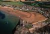
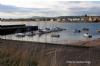
The harbour is on the east side of a small bay at the end of a curved isthmus and protected from the SW by a pier wall; local bilge keel yachts lie in a couple of trots inside this protection with another couple of trots serving flat bottomed boats between them and the sandy beach.
The most prominent feature is the old granary which is now converted to flats. These rectangular buildings are to be found at many of the ports on the East Coast of Scotland from the Moray Firth to Eyemouth; some are converted to flats as the trade in agricultural products fell away, others became fish markets. Nowadays the export of grain is done directly by lorry to waiting bulk carriers in places like Peterhead.
Approach
We have given a way point well out in safe water.....
..... as the reefs to the East of Chapel Ness are quite extensive though if coming from the Anstruther direction (East), as long as you stay a couple of cables clear of Elie Ness, you can cut the corner a bit. In strong onshore weather (Force Five and above) it would probably unwise to attempt this harbour as you would have to turn across the sea (which would be breaking at half tide) to gain the shelter of the pier and that would be a bit tricky for an inexperienced sailor.
Otherwise the harbour is well sheltered and easy to enter. The harbour is quite easily identified by the large building at the root of the pier and the lighthouse on Elie Ness.A perusal of the charts will show that there are off-lying rocks to the West of the bay whilst reefs extend out from the shore to the East.
There is room to anchor on the South side of the bay between Elie Ness and the back of the granary (known as Woodhaven Bay); it is strewn with rocks and, although it provides good shelter in Easterlies, you would be advised to explore it at low tide before choosing an anchorage in it.
If you head directly for the end of the pier from our waypoint you can’t go too far wrong but if you have a deepish keel you would be advised not to make an approach before half tide on the flood; bilge keelers with a draft of 1.5 metres should be able to get in 3.5 hours either side of HW.
Apart from the all round light on Elie Ness there are no lights to assist with night navigation so a night entrance is inadvisable.
If you arrive early there is a yellow waiting buoy off the pierhead where you can await the tide.
Berthing, Mooring & Anchoring
There is a visitors berth against the wall at the root of the pier..
the wall is clearly marked “Visitors Berth” and has a ladder and depth gauge on the wall.The channel to the berth is between the wall and the first trot of yachts which doesn’t give you much manoeuvring room to turn onto the wall; we risked running down between the first and second trots (drawing 1 metre) at half tide and got away with it but the depth sounder had us worried.
There is a harbour website with contact details at https://elieharbourtrust.org.uk/
If you have contacted Stewart, the part time harbour master, he may well be waiting for you and will give a hand with your warps.For departure, if there is a ladder free, normally one would shift position to the harbour wall on the tide before and gain about an hour of floating time on the next rise. In 2020 the visitor charge is £15 per boat per night or £50 per week up to a maximum length of 8 metres.
Facilities
Shore power and water are available on the wall of the granary opposite the ladder on the visitors berth. Showers and toilets are available in the Sailing Club building for which you need the entry code. There are also showers and toilets available in the small building halfway along the isthmus but these are daylight hours only. There are no fuel facilities but you may be able to get assistance from one of the creel boat owners or a member of the Sailing Club to get fuel from a garage, the closest being Clinsborough, approximately 2.5 miles inland.
There is no chandler here and no supermarket from which to do a major re-supply of the galley, but you will find that there a few well stocked shops in the village which can sell you the basics. The delicatessen can cover most of your high quality food & drink requirements, and the bakery at the end of the High Street is open until 2:00pm. The hardware store caters well for visitor needs, with a large stock of all types.
Eating, Drinking & Entertainment
The foreshore at the end of the isthmus hosts a pub (The Ship Inn) and an outdoor café, though we were advised at Anstruther that the pub beer was expensive and that the pub on the High Street are cheaper. At the weekends, and through the week during the summer, the Harbour Café at the Sailing Clubhouse serves a variety of snacks and seafood platters for visitors. The Pavilion Cafe, Golf Club Lane off the High Street at the Earlsferry end, is open from 0800 for breakfast, and also serves a varied menu throughout the day and into the evening.
Restaurants & Places to Eat in Elie - Tripadvisor
For those of you with a big enough boat to carry your clubs, there are two excellent, collocated Golf Clubs here
Links
|

Got a comment to make about Elie Harbour ? Have you found this coverage helpful ? HAVE YOUR SAY (your email address will always be kept private)
Your Ratings & Comments