You are viewing the expanded version of this Harbour,
for faster browsing
use the regular version here

Eyemouth (Almanac stub)
Courtesy Flag
Flag, Red EnsignWaypoint
55°52.8N 002°05.34WCharts
AC 0160 St Abb’s Head to the Farne Islands; AC 1612-9 Eyemouth Harbour; Imray C24 Flamborough Head to Fife Ness (with harbour plan of Eyemouth); SC5615.8A Admiralty Folio Holy Island to St Abb,s Head; SC5615.8B Eyemouth HarbourRules & Regulations
Look out for a red flashing light or red flag on the promenade behind the harbour entrance; when this is showing it means it’s unsafe to enter either the bay or the harbour (if you haven’t already realised this yourself!). Do not use the fresh water supply to wash down your boat – they threaten a fine of £150 if you do.Hazards
Off shore rocks at Burnmouth 2 miles south of here. The Hurkars and Luff Hard Rock in the close approachesTidal Data Times & Range
HW Eyemouth is same as HW Leith give or take five minutes and +0330 on Dover. MHWS 5.2m MHWN 4.1m MLWN 2.0m MLWS 0.9m; Tide link for Dunbar (Ed Note: virtually the same as Eyemouth which is Leith -5 to +7 and Dunbar is Leith -5 to + 3) (links)This site is designed for slower, roaming broadband connections, like you would get at sea, so it needs JavaScript enabled to expand the text.
General Description
Contacts
Harbour Master 01890 752494, mob 07885 742505, VHF 12 & 16
This is an "almanac stubb" the author has not been into Eyemouth on his own boat yet.
Eyemouth is a popular stopping off point for sailors cruising this coast; it’s a good day’s sail (45ish miles) from Anstruther, Granton or Arbroath, a gentle afternoon from Tweedmouth or 40+ miles from Amble which explains its popularity.
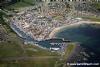
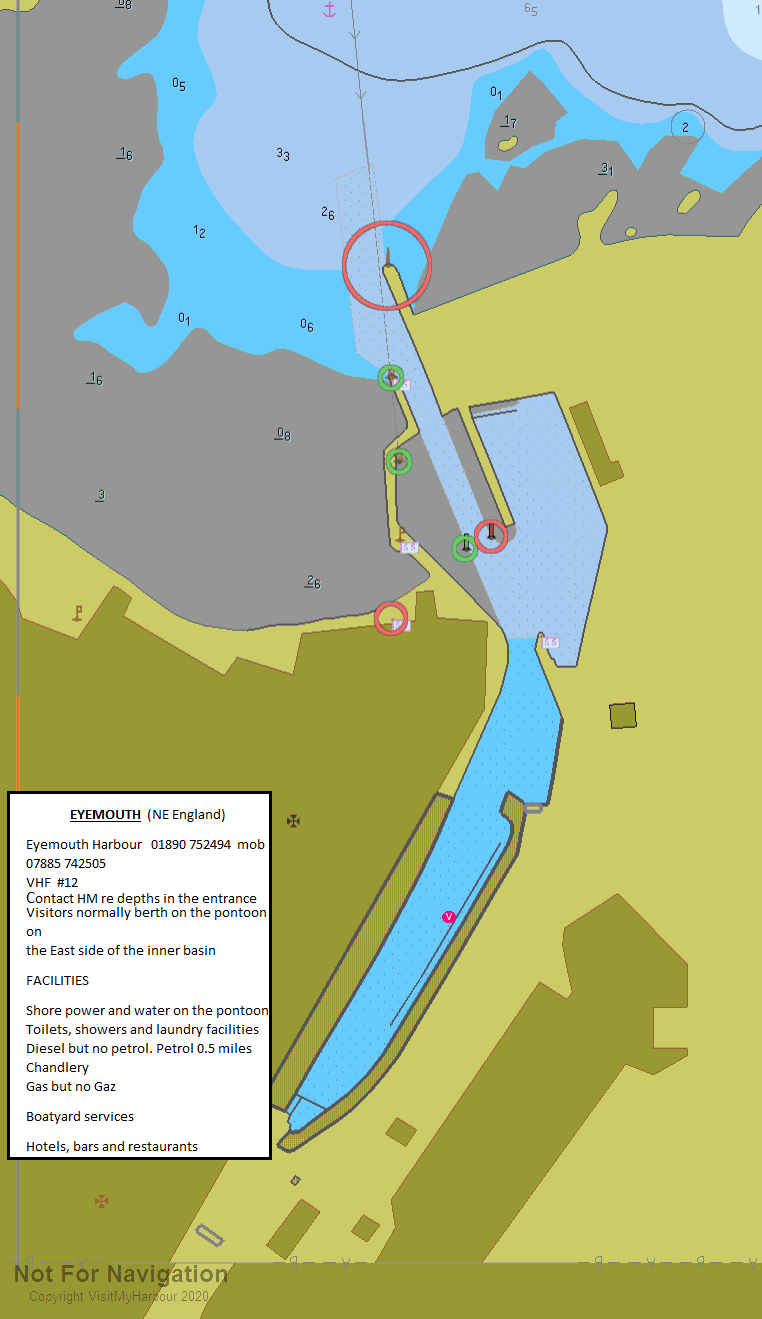
The harbour has been formed by reinforcing the banks of the River Eye Water where it flows into a cove just to the west of Gunsgreen Point; the seaward side of this cove is protected by a reef of rocks called the Hurkars which can be passed on either side depending on your direction of approach.
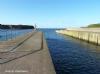
The port itself supports a sizeable fishing fleet along with visiting boats from the South during the summer fishing season but these are, in the main, kept separate from the yachting fraternity which is catered for on the East side of the harbour. Obviously you will meet these FV in the approaches and should keep a weather eye out for them especially in the harbour entrance which is only 17 metres wide. They have increased the pontoon space by adding another pontoon to the West wall of the inner basin.
The mainstay of the town has always been the fishing industry and its fortunes have thus ebbed and flowed around that; despite this the harbour has a reputation for good hospitality to visiting yachties and most of those visiting have remarked on this. In recent years they have added a long, serviced pontoon on the East side of the inner harbour which is popular enough to require visiting boats to raft together on it, indeed you may find that to berth against the quays on the east side or in the Gunsgreen basin you may still have to raft (there is a difference in the tariffs for the quays and the pontoon, about which, more below)
Eyemouth has won a contract to service the NnG Wins Farm off Fife Ness and that work is being done on the land at the North end of the harbour on the East side of the entrance and will be carried out from the North Dock.
We have been assured by the HM that the East pontoon is very much in the business of catering for visiting leisure hulls but that he would appreciate advanced notice of your intention to call in.
Approach
Firstly, even in a moderate blow, do not think of trying to get in here in winds....
.... from the North round to the East because it turns into a maelstrom in the bay. (Mind you, on this coast, anyone venturing out of anywhere with strong on shore winds in the forecast needs his head looking into!)
Having said that, from the South there are few off shore hazards but be careful if you are closing the shore to photograph the cliffs because there are some isolated rocks around especially off Burnmouth. From the North you will be coming around St Abb’s Head which is steep to; the advice here, especially in wind against tide conditions, is to stay in close to the headland where there will be less of a chop. The ESE tide at St Abb’s starts about three and three quarter hours before HW Leith/Dunbar.
If you’ve come up from the South in settled conditions you’ll be arriving at fairly low water so the Hurkars will be very evident as will the rocks extending out to the north of Gunsgreen Point; as long as you are happy with the nav, it’s perfectly ok to slip through to the south of the Hurkars and turn into the harbour mouth as it opens just to the East of south of you. On the other hand, if you are at all unsure then continue past the Hurkars to the North Cardinal Mark and start you approach rounding that. (Obviously you’d adopt this plan of attack at night unless you have radar and are good with it!)
From the North you will have come round St Abb’s head and be able to see Gunsgreen Point ahead (once you’ve passed Horsecastle Bay, half a mile down the coast from St Abb’s, it’s the next headland down). If you’ve given St Abb’s more than a mile offing then it won’t be so easy as Gunsgreen is going to meld into the coastline to the south of it- ‘twas ever thus (you may have had the same problem finding Stonehaven from the north!) Anyway, all you have to do is plod down the coast until the harbour mouth opens and then allow it to just close and come in on that line (174°T or so)
For a night approach you’ll notice that they use the green light on the west breakwater and a further green light behind and a bit above as leading marks and that when you are on the correct line the Iso red on the west breakwater will be a touch to the left of those. Be very careful not to get these muddled up with the Q.G and Q.R on the buoys at the inner end of the dredged channel or you’ll be in trouble; personally I’d spend a few moments getting them right before I ploughed on in (the leading lights will, naturally, be hidden in amongst the street lights of the town!)
As a stranger, I would hesitate before deciding to make my first approach at night.
A call to the HM on channel 12 is recommended for advice on the state of the dredge etc.
Berthing, Mooring & Anchoring
Once in the harbour you will have two options; although there are now two pontoons, as a visitor you will end up on the Easterly pontoon on the port side as you come in.. (the westerly one is normally for local boats)
You will have discussed this with the HM before hand on your approach and will have fenders etc ready (there may not be time to do this once in the harbour). There’s plenty of room to turn the boat round into wind, especially if you have a decent paddle wheel effect) and you should expect to have to raft. (I’m told that they are sometimes three deep at peak times).
They will charge you (2022) £25.00 for up to 10 metre boats and £2,50 per each additional metre above that. . Further details can be found (along with multiple photographs) on their website. There is a very useful video of Eyemouth on that site.
http://www.eyemouth-harbour.co.uk
Eyemouth Harbour - Spring 2020 a word from the Harbourmaster:
Visiting yachts are welcome at Eyemouth, with a serviced pontoon in the tidal upper harbour which has a depth of 0.9m alongside. Showers, washing & drying machines and other facilities are available in the harbour office building close by.
Depths in the Upper harbour and alongside the visitor’s pontoon are as charted at 0.9m, however a shallow area exists where the river issues into the harbour, in front of the RNLI station house. Visitors are advised to keep to starboard when entering the Upper Harbour before crossing to the Visitor’s Pontoon on the port side.
Update 2021 They have continued the dredging campaign here into this year and are reporting CD - 0.8 in the Inner Harbour. This means that at MLWS you should get close to a couple of metres alongside the pontoon - but consult the HM if that is marginal for you.
Facilities
Water and shore power can be found on the pontoon and shore power is available on the quaysides as well, though you will probably have to carry your water there. There are toilets and showers to be found in the Harbour Office building. You will require 2 X 50p coins to operate the showers. They supply power cards for the shore power - but before purchasing one of those check that the previous occupant hasn't left credit on it!!
They can supply diesel in the Gunsgreen Basin but I’m afraid the petrol station is a good mile’s hike away.
You will find a chandlery and boatyard here but the chandlery, although it does Calor gas, does not stock refills for 907 Camping Gaz cylinders. Other than that, as has been said, this town lives and dies with its fishing industry so you will be able to source repairs for everything you’ve broken so far on your travels!
For restocking the ship’s larder there is a Co-Op and a Costcutter which are quite small so you’d get what you need but not much choice in brands.
Eating, Drinking & Entertainment
Your much abused crew will be able to find much to sustain their appetites here though the more base of those are in much shorter supply than they were back in the 1800s when Eyemouth had a fearsome reputation for debauchery!
There is also a not-to-be-missed Boat Museum with both full sized and replicas in abundance. You can’t miss it ; the northern face is done up to look like the stern quarters of a man o’war in the black and buff colours of Nelson’s Navy.
For a choice of restaurants search here
Links
|

Got a comment to make about Eyemouth ? Have you found this coverage helpful ? HAVE YOUR SAY (your email address will always be kept private)
Your Ratings & Comments
Showers 50p coins x 2 or contactless.
Ed: Thanks for the correction. Have updated.
That the facillities don't work have no effect on the harbour fee.
The site of the old boat museum is being developed with 'pods' and the like. Phase 1 might be ready later this summer.
Prices have gone up. Flat fee is now £25 and showers are now £2.50. If we had showered that would have beein £30 a night for a 7m boat. Can anyone find anything this expensive outside the Solent and Poole Harbour?
View all 11 feedback items