You are viewing the expanded version of this Harbour,
for faster browsing
use the regular version here

Loch Eriboll
Courtesy Flag
Flag, Red EnsignWaypoint
58°33.9N 004° 37.5WCharts
AC 1954-0 Cape Wrath to the Pentland Firth including the Orkneys; AC 2076-0 Loch Eriboll (no large scale chart of Loch Eriboll)Rules & Regulations
NoneHazards
The tidal streams off both Faraid Head and Whiten head can produce confused seas even in settled weather.Tidal Data Times & Range
HW Rispond Bay is -0340 on Dover. Range is about 4m Springs and 1.6m Neaps.This site is designed for slower, roaming broadband connections, like you would get at sea, so it needs JavaScript enabled to expand the text.
General Description
Contacts None!!
Loch Eriboll is a popular stopping off point for those intending to, or who have just managed to, weather Cape Wrath
Shelter is good for anything but strong Southerlies or strong Northerlies and even then, if you choose your anchorage wisely, there is only the wind to deal with as the swell is damped by the land. In unsettled weather it is a good idea to ride to two bridled anchors or set an anchor watch as the funnelling effect of the glens can be experienced in all wind conditions and even a slight change in direction can produce unexpected results!
Probably the best advice to give for those intending to stop here is that adverse conditions can last for quite a while. Communication is difficult; only O2 has mobile coverage and even that has to be explored for; there is no broadband connection of any sort. The good thing is that the Coast Guard seems to have reasonable coverage on VHF so, for emergencies, at least you can contact them (mind you, I don’t think they’d consider running out of bacon to be an emergency!!)
The only evidences of humans are the farmsteads clinging to the sides of the hills and the occasional groups of habitation on the Western side of the loch. There are no shops, no Post Offices, no filling stations and no bus services apart from the school bus in the morning and the afternoon. There is regular through traffic on the road around the loch but it tends to be either packs of motor bikes or left hand drive camper vans and it was found that none of these stop for marooned sailors.
So, be warned, you will have on board only what you arrive with and you will be unable to replenish any of it.
That’s all the negatives over with; the chances are that you will arrive here, drop the pick and breath a sigh of relief. Hopefully it won’t be raining (hollow laughter!) and you can break out the gin or cocoa (according to your preference in these matters!) and sit and take in the view which is something else; and the silence; okay there’s a bit of stuff on the road but other than that, the rest is nature; keep the binoculars and camera handy as your chances of sighting a sea otter chuntering past the boat as the sun sets are very high.
Mind you, it depends on your direction of travel; if East bound you’ve experienced all the delights of this part of the world and are progressing towards civilisation, it’s all a bit déjà vue; if on the other hand you are West bound this is all new and you can be forgiven if you think you’ve died and awoken in heaven!!! If it is of any help, “Eilean” is an island, “Sgeir is an isolated rock or Skerry and “Camas” is a harbour or bay; for anything else there’s the internet!
Approach
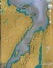
It is not easy to pick out the entrance to the loch from a distance.................................
there are apparent inlets and glens all along the approach from the East and, until you are a couple of miles away, Whiten Head is not easily identified. It can be a bit unsettling but you just have to trust that if you have been progressing along the line you drew on the chart the night before then you will eventually be able to pick out that headland out from all the others. If it is of any help Whiten Head is a steep-to cliff and from some angles you can see the off shore stacks which, in good light are white against the cliffs.
Sorry we have no photographs of the approach but to give you some idea the first photo “Entrance to Loch Eriboll” was taken between Eilean Clumhrig and Freisgill Head when outside it was blowing between F4 and F5 (hence no photos, short handed).
Once into the entrance of the Loch look ahead for the white lighthouse on the east side beyond Sgeir a’Bhuic (at night you want to run in on the white sector of that light (Fl 10s)) and make towards that and then follow round to the SW to gain the heart of the loch.
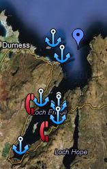
Berthing, Mooring & Anchoring
There is a small privately owned harbour at Rispond Bay which should not be used without the owner’s permission....
.... and a pier at Portnancon used by visiting fishing boats and of not much use to visiting yachts. So, you will be looking for an anchorage, preferably out of the wind.
Rispond Bay (58°32.9N 004°39.4W) is sheltered in all but Easterly winds and is useful if just stopping overnight. Temporary shelter in suitable conditions can also be found in the SE lee of Eilean Hoan.
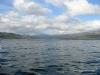
Further into the loch you have a choice between the West side and East side halfway down. On the East side there is good holding in either bay North and South of Ard Neakie but in Southerly winds it’s better to go a mile further down to Camas an Duin. Careful here, the Clyde cruising notes say to anchor “off the white house” which is confusing as there is a very prominent white house about half a mile further down which is definitely not a good place to anchor; the chart says “red roof” and that is what to go for, in behind the fish farm.
Our Photo “Loch Eriboll looking SW” shows the “white house” and you can see for yourselves why it’s not a good place to clew up. On the West side, opposite Ard Neakie is Portnancon which is the preferred anchorage in Westerlies and North Westerlies but, if you can take the bottom and elect to tie up to the pier, be aware that fishing boats do visit here as well.
In most of these anchorages you will be surprised at how close in you can get to the shore and still have enough depth at low water but, as has been said, for peace of mind you might consider anchoring to two anchors on a yoke on the bow a) to reduce scope close in to the shore and b) to increase your holding should the wind turn in the night.
If you want to see what it can be like up here have a look at
Other bits – sailing Fiesta (fiesta40.net) and select the video "Rocna - my saviour" which was experienced by our member and described below.
Facilities
You are going to find that you are suddenly back in the dark ages of leisure cruising and your only weather information will be the three hourly reports given out by the Coast Guard (for Cape Wrath to Rattray Head) or, if you can get the reception, the Shipping Forecast on the steam radio (you want the Fair Isle one)
There are none of the usual facilities; no toilets, showers, shore power, shops, buses or Wifi. No petrol, diesel, Gas or Gaz.
The Clyde Cruising Club mentions the telephone box on the east side and quotes 2miles as its distance from Camas an Duin, it is in fact only 1.75 miles but it’s up hill and down dale and seems a lot longer; be assured that it was definitely there in the summer of 2012 and was working!! It's adjacent to the T-junction south of Camas an Diun at the Eriboll Estate.
The nearest supplies on the West side are at Durness and on the East side round the corner in Tongue, both over a dozen miles away. So, unless you want to end up on hard tack, salt beef and rum, make sure you have more than the usual supplies of tinned and dried goods on board. Water can be obtained from burns and springs
Having said that, in extremis, if you knock on the door of any of the cottages you’ll find the people here are very helpful, they understand the problems of supply and will willingly help you out, either from their own stocks or when they go into the local “town” to shop for themselves
Eating, Drinking & Entertainment
Hope you are good at entertaining yourselves! The only problem is that when stuck here because of bad weather it can be miserable at anchor so as soon as it is nice you’ll want to be off again; if the weather is promised good for a couple of days it really is worth just sitting and soaking it in; places are meant to be enjoyed not just arrived at!!
Links
|

There is an video of some of the gale in Loch Eriboll entitled 'The Rocna, my hero' under the 'Other bits' section of my blog that can be found under
www.fiesta40.net
All the best and thanks again for the excellent site content at Visit My Harbour
Mark"
Your Ratings & Comments
Shifted up to the other side at Bagh Loch Sian, and got perfect holding just South of the beach there. Beautiful Loch.
You do feel you are in a safe anchorage but I guess in a gale you would be quite exposed.
Sailing east from here, you witness the landscape changing from wild west to arable east in a remarkably short distance.
My route from Essex was clockwise so I made the jump to Loch Eriboll from Stornoway. There had been a few gales which kept me in Stornoway for two weeks but a 5 day weather window presented itself so I headed out. When I was about 15 miles from Cape Wrath Stornoway coastguard issued a warning of a southerly gale 8 'soon', the possibility of which didn't appear on any forecast previously.
Being too late and the wrong wind direction to turn back I continued as planned into Loch Eriboll where I anchored right up at the head of the loch on the east side off the small house / sheepfold. I anchored in +/- 20 feet of water and let 160 feet of scope out and went to bed only to be woken at 5am by the howling wind.
The direction was southerly and although I was anchored as best as I could be behind the mountain, the way the wind funnels into the loch there really wasn't any shelter from the wind although swell was no problem being so close up to the head of the loch. I had the best part of 24 hours of nail biting with a many recorded gusts at deck level of over 50 knots and sustained winds of 35 to 45 knots. I am pleased to say that my only drama was having to right the capsized dinghy which I should have got on the davits the previous night. The holding proved to be excellent. I did move slightly, according to my drag queen app, about 20 feet but the bottom is mud and all the anchor did was dig in deeper. So deep in fact that it took me half an hour to motor it out before I left.I underestimated the lack of shelter afforded in the loch and in the same situation again I would row out a second anchor as suggested on your web page for Loch Eriboll.
I can also confirm that, again as mentioned on your web page, communications in the lock are challenging or more accurately, for me, impossible. I use EE and had no suggestion of a signal. I did not receive a navtex forecast whilst in there and nor could I pick up any of the coastguard issued shipping forecast on my VHF and nor was there any fm /mw radio reception so it certainly does feel isolated and 'off the radar'. The only equipment I had onboard to give me any suggestion of the weather was the trusty barometer!
Anyway, I thought it would be useful to relay this experience because despite the lack of shelter from the gale, the holding couldn't be faulted. Fyi info there is an video of some of the gale entitled 'The Rocna, my hero' under the 'Other bits' section of my blog that can be found under
www.fiesta40.net (Clickable link in "Links" section)
All the best and thanks again for the excellent site content at Visit My
Harbour
Mark"