

Harbour Information (use the  icons to find out more)

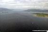

Carlingford Lough, Harbours and Anchorages
Your Comments: 12 Read or add your comments
Courtesy Flag
Irish Tricolour/Red EnsignWaypoint
54° 00.235N 006° 02.30WCharts
AC 0044 Nose of Howth to Ballyquintin Point; AC 2800-0; SC5621.8; Imray C62 Irish Sea with insets for Carlingford Entrance and Carlingford MarinaRules & Regulations
NE part of Lough is in Northern Ireland, SW part is in Republic of Ireland. The dredged channel is a “narrow channel” within the meaning of the IRPCS rules and small vessels should not impede those restricted by draft. Additionally there is no overtaking/crossing of vessels between buoys 1 – 9, 11 – 21 and buoy 21 & Warrenpoint. This essentially means that, combining the two rules, a small yacht should leave the channel altogether if encountering a large vessel within it.Vessels should also avoid anchoring or grounding in the areas on the chart designated as shellfish beds.
Hazards
There are strong tidal streams both through the entrance and within the Lough. As would be expected strong Southerlies can set up quite a chop within the Lough but, in addition to this, North Westerlies can be funnelled down the Lough and produce worse sea states inside than outside. (remember that you could be entering with the flood and against any NW wind; setting up a classic wind against tide situation). Anything above F5 on shore (E thro’ to SSW) makes the entrance difficult and on an ebb tide in these conditions the entrance becomes impassable in any direction.Tidal Data Times & Range
Cranfield Point: HW Dublin -0020: MHWS 4.8m MHWN 4.3m MLWN 1.8m MLWS 0.9m See Notes in approach sectionThis site is designed for slower, roaming broadband connections, like you would get at sea, so it needs JavaScript enabled to expand the text.
General Description
Contacts:
Warrenpoint HM VHF #12 tel +44 (0)2841 752878
Carlingford Lough Yacht Club tel +44 (0)2841 738604
Carlingford Sailing Club tel +353 (0)42 937 3238 (International rates from UK mobile)
Carlingford Marina VHF #37 tel +353 (0)42 937 3072 (International rates from UK mobile)
www.carlingfordmarina.com ... read more
Approach
Tidal Information:
It is worth noting that tides at Cranfield Point..... ... read more
Berthing, Mooring & Anchoring
Greencastle. As has been said, this is the first anchorage inside.... ... read more
Your Ratings & Comments
12 comments
Increased charges 2026
Written by Antofa | 3rd Apr 2026
Enjoyed our stay in Carlingford Marina, Monica was very helpful (thanks!)
Price is now 35 euros regardless of size...
Price is now 35 euros regardless of size...
Carlingford Marina - Increased Charges May 2023
Written by Eebygumcaptain | 7th May 2023
No changes other than daily charge increased to €30 a night for visitors.
UPDATE OCTOBER 2022
Written by Don Thomson 3 | 6th Oct 2022
I reviewed these notes in October of 2022. I can't improve on the information noted below. We are so concerned at the effects of winds around here that we put a copious note in the "Hazards" section at the beginning; our member below advises strongly in support of that; do not underestimate the effect of wind against tide around here - and the Google overhead makes the entrance look like a trout stream!
Give it a go
Written by Charlie Bravo | 4th Aug 2022
Carlingford Marina
July 2022. We visited twice on this trip, escaping storms, entry and exit first time no problem.
€25 a night per boat of any size, inc. shore power and water, internet is included but is a bit sketchy.
Facilities found wanting, one toilet and two floaty curtain showers for the men, could be better.
Laundry and fuel on site, white diesel in cans.
The pontoons are wobbly, plans to replace them are in place, did I mention the price?
Good bar with food on site, or 20 min walk to the village.
Friendly staff, a family run business with a good atmosphere about it.
The pontoon access involves a ladder onto a concrete ship, at springs it can be a challenge to get to and from your boat at some times…… €25 !
Bike hire by the marina, and good bike rides available.
Locals talk of the ‘Carlingford Kettle’, this is a local wind effect causing the water to appear to boil, in effect it can blow 2 forces more than forecast , usually with a NW wind funnelling down the valley, and looks quite impressive from shore.
Advice to avoid onshore winds for getting in and out to sea should be adhered to, we left with 10-14 knot south wind , so cross on shore, passed the lighthouse at 8.5 knots in smooth water, spotted white water ahead and clipped on. We fell off the first wave, and the next lot for half an hour with waves over the deck, before the sea moderated to just rough, it tests your stowage skills.
We enjoyed our stops here, not like the gold anchor marinas, but all low stress, except for our final escape, and despite the negatives is worth a visit, and a handy stopping off point.
Jeanneau 35, 1.85M draft, (they have about 5 deepish jetty moorings.)
UPDATE SUMMER 2021
Written by Don Thomson 3 | 23rd Aug 2021
I reviewed these notes in August 2021. They are continuing with their single price (25 Euros) covers all visiting boats. We have noted the comments below reference the depths at the visitors berth depths. Avoid approaching them an hour either side of LWS - once there you may sink into the mud if you have a draft over a metre.
Depth Problems
Written by Red Fox | 22nd Jul 2019
I went aground on a visitors berth in approx 1m at low water in 2019.
Another boat, drawing 1.6m, also went aground approaching a visitors berth.
Another boat, drawing 1.6m, also went aground approaching a visitors berth.
1 of 1 people found this helpful
Update Summer 2019
Written by Don Thomson 3 | 11th Jul 2019
These notes were reviewed in July 2019. There is a new price at Carlingford Marina; 25 Euros per boat per night irrespective of size
UPDATE APRIL 2017
Written by Don Thomson | 20th Apr 2017
I reviewed these notes in April 2017. The prices remain the same and I've posted new charts.
Carlingford marina
Written by Taff | 4th Jul 2015
We draw 1.5m and had no depth problems in the NW part of the marina, although the fuel berth is not accessible at low water. Some of the pontoons are tired, needing a number of minor repairs. The on-shore amenities are good, and the staff helpful. There is a good restaurant (currently not open during the evenings). Nice walk to Omeath, and bus trip to Newry.
0 of 1 people found this helpful
Hazards
Written by Taff | 4th Jul 2015
The note above re wind funneling down the loch is to be taken seriously. Although it was only NWF2 off the coast, we battled against a NWF4 over the young flood on entry, We went around significant standing waves off Greenore.
1 of 1 people found this helpful
View all 12 feedback items


© visitMyHarbour.com | website design created by Black Culm Ltd