You are viewing the expanded version of this Harbour,
for faster browsing
use the regular version here

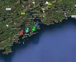
Castle Haven, Squince Harbour and Blind Harbour
Courtesy Flag
Irish TricolourWaypoint
51° 30.5N 009° 10.2WCharts
AC 2092 Toe Head to Old Head of Kinsale; SC5623.15 Toe Head to Clonakilty Bay; Imray C56 Cork Harbour to Dingle Bay (Harbour Plan of Castle Haven)Rules & Regulations
None KnownHazards
Belly Rock (awash at High Water) to the South of Rabbit Island on the direct track from Glandore Harbour to Castle HavenTidal Data Times & Range
Castletownshend: HW is HW Cobh – 0028 MHWS 3.7m MHWN 3.0m MLWN 1.4m MLWS 0.7mThis site is designed for slower, roaming broadband connections, like you would get at sea, so it needs JavaScript enabled to expand the text.
General Description
Castle Haven and the village of Castletownshend half way up its....
.... western shore is a popular destination for cruising sailors and is the home of the South Cork Sailing Club. The Sailing Club does not have its own clubhouse but uses the Rowing Club for its formal meetings and the local pubs for social events. The telephone number for the Sailing Club in the Reeds Almanac is that of the Castle which is (and has been since the mid 1600s) the residence of the Townshend family who now open some rooms as B&B.
Between Castle Haven and Glandore harbour there are several inlets and anchorages which may be explored and used in settled off shore conditions but this small area of sea must be approached with caution as it abounds with rocks, islets and hidden dangers and has no large scale charts to assist one. Like most of this coastline the Admiralty Charts are based on mid 19th Century surveys; the buoyage and lights are up to date but the actual positions of rocks may not be exactly in line with GPS positioning, even allowing for the adjustments required for WGS 84. You’ll find this warning repeated on all the Droggie’s charts.
Adam’s Island, Rabbits Island, High and Low Islands along with Skiddy Island all have their necklaces of drying and hidden rocks so must be given a reasonable offing and one of the best sources for information has to be the Irish Cruising Club’s Pilot Book for the South and West Coast of Ireland. In this you will find useful transits and photographs to assist you - especially if you want to explore the inshore routes.
Having said that it should be noted that, of the various routes available from Adams Island to Reen Point, the longest (4.5 miles) is round the outside of High Island and then in via our Initial Fix; the shortest route outside Belly Rock, through Big Sound and skirting round Skiddy Rock is 4.0 miles. So unless you are trying to make it before closing time it really doesn’t make a lot of difference which way you go and if you are coming from further away the route to Castle Haven via our initial fix is as fast as any.
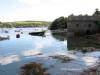
Anyway, along the coast there are three or four places you could stop for a look. There’s Carrigillihy Cove which is narrow and dries at its landward end. Here there are rocks extending out 50 meters from the west shore of the entrance but you will find enough water to anchor afloat just off the coves on the eastern side. There’s a link to a Google Maps Photo below
Google Maps (Opens in a new tab)
Half a mile to the West of this there is Squince Harbour and it is possible to go through the channel between Rabbit Island and the mainland but ever so carefully. There’s a reef right across that passage with a least depth of only 1.2 meters (so you’ll be ok at HW) and you need to be about 50 meters off the shore of the island as you pass through the narrowest bit. It wouldn’t be too bad in a shallow draft boat but if you are carrying nearly 2 meters draft it’ll certainly exercise your sphincter muscles and you’d probably be best off going round the outside. Squince harbour is absolutely no use in onshore winds. To put it in perspective the Google link below shows the view looking East from the strand at the western end of Squince harbour; that island in the middle of the entrance is Rabbit Island and the gap between it and the headland is the channel we’re talking about; it’s just not worth the candle.
Google Maps (Opens in a new tab)
Of the anchorages along this coast the next, Blind Harbour, is probably the most viable; especially if you can take the ground. It has a fairly narrow entrance strewn with rocks along its eastern side but then opens out into a lagoon which, if you can dry out but only if, will provide shelter in most weathers apart from a howling Southerly gale; if you carry any draft you will have to anchor at the end of the narrows and there’s no protection at all from the weather there.
Approach
We have covered most of this except the straight run from Adam’s Island through Big Sound to Skiddy Island.
To follow this route safely using the Mark I eyeball you will need at least five miles visibility and settled conditions; if you intend to use a GPS as primary navigation in low visibility, plot your course in a zigzag through the widest bits of the channel and give that Belly Rock a wide berth; don’t even think about GPessing through between Rabbit Island and South Rock.
If you have the necessary visibility to pick out the northern of the twin summits on Beenteeanne then you can line up Black Rock (which is small and low) with it and follow that line through South of Belly Rock to abeam Low Island when you can shape your course for Skiddy Island.
After that it is just a case of heading for the middle of the gap between Reen Point and The Battery and working your way up to Castletownshend to find a suitable spot to anchor for the night.
Berthing, Mooring & Anchoring
The minor coastal anchorages have been covered above.
In Castle Haven itself there are several options. At Castletownshend anchor either side of the main channel as there are reports of sea grass on the bottom in the middle of the channel which will make the holding weaker. We are told that there is a good place to anchor on the Western side just before you get to the main moorings.
Just to the North of the village there is a promontory (Cat Island) which would give better shelter than further down the bay but tends to have a fair few boats on moorings which limits the chances of finding space for yourself. If you have come up at HW, the lagoon beyond the gravel spit will look inviting but there’s only a very shallow covering of water there and it is not an option unless you want to sit on the mud for a lot of your stay.
The river further up is navigable if you have a shallow draft and you’d be able to find a spot to moor fore and aft but you would be giving yourself a long row back to what passes for the centre of civilisation here!!
One place that we haven’t mentioned is the sandy bay on the West side of the entrance just above Battery Point which would provide an anchorage in settled conditions but it is very open to the weather if it should spring up from the South.
Note that there is a submarine cable crossing the inlet from the Castletownshend side to the slip at Reen.
Facilities
There is water on either side available from a tap on Reen Pier and one on the slip at Castletownshend. There is enough depth from half tide to come alongside the pier at Reen if you need substantial re-bunkering. Other than that there is a shop at the top of the main street which does have gas and petrol (but no diesel)
Eating, Drinking & Entertainment
A stroll up the Main Street (“up” being the operative word) will lead you to Mary Ann’s Restaurant which, by all accounts, should not be missed. Our member in Ningaloo was disappointed with this watering hole but it does receive rave reviews elsewhere (though there has been an adverse report on their fish an' chips!) They also house an Art Gallery there.
The Castle is open to visitors during the summer and there is also a church here which holds a series of classical music concerts on Thursday evenings in July and August which are held in high repute. You can expect the village to be very busy on those evenings.
Links
|

Your Ratings & Comments
A little disappointed with Mary Ann's restaurant. The lamb rump was more like slices of reheated roast and the monkfish was smothered in a cream sauce that was not to my taste.