

Harbour Information (use the  icons to find out more)

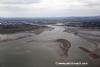
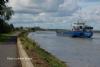
Dundalk
Your Comments: 6 Read or add your comments
Courtesy Flag
Irish TricolourWaypoint
53°58N 006°16.8WCharts
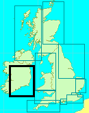
AC 0044 Nose of Howth to Ballyquintin Point; AC 1431 Dundalk and Approaches; SC 5621.3 Annalong to Drogheda; Imray C62 Irish seaRules & Regulations
The dredged channel is a “narrow channel” within the meaning of the IRPCS rules and small vessels should not impede those restricted by draft.Hazards
Shoals and shallows off Dunany, Ballagan and Cooley Points. Dundalk Bay itself dries as does the dredged channel.The dredged channel is bounded by training walls which are covered at HWTidal Data Times & Range
HW Dundalk (Soldiers Point) is HW Dublin – 0010; MHWS 5.1m MHWN 4.2m MLWN 1.6m MLWS 0.6m; The stream in the channel can be quite strong, especially after prolonged rain. The flood starts at Soldiers point five hours before HW Dublin an the ebb a few minutes after HW DublinThis site is designed for slower, roaming broadband connections, like you would get at sea, so it needs JavaScript enabled to expand the text.
General Description
Contacts:
Dundalk HM VHF #14 mobile +353 872847566
Dundalk Pilot VHF #14 mobile +353 872524188 ... read more
Berthing, Mooring & Anchoring
The most probable location for your stay will be at the Western end of the docks ... read more
Your Ratings & Comments
6 comments
UPDATE OCTOBER 2022
Written by Don Thomson 3 | 10th Oct 2022
No chaanges
UPDATE SUMMER 2021
Written by Don Thomson 3 | 26th Aug 2021
No changes; there is still very little here to attract a yachting skipper.
Update Summer 2019
Written by Don Thomson 3 | 18th Jul 2019
These notes were reviewed in July 2019. The charts have finally caught up here and the buoyage at the entrance to the approach channel has been clarified. I note that there were quite a few ship movements here in 2018 with a mixture of cargoes from grain to wood and scrap iron so don't assume that there is nothing happening here.
UPDATE APRIL 2017
Written by Don Thomson | 21st Apr 2017
I reviewed these notes in April 2017. It's sad. There hasn't been a visiting yacht here in living memory and now they seldom see a commercial boat. We've kept it in our almanac in hope and warned the Admiralty that the No 2 buoy flashes GREEN.
Update 2015
Written by dononshytalk | 15th Apr 2015
These notes were reviewed by Don in April 2015. Despite the fact that the No 2 PHM is shown on this year's Admiralty chart as Fl.R3s it definitely is NOT - it's Fl.G3s and should be left to starboard. We have double checked our contact numbers for the harbour and they are correct.
Update November 2013
Written by dononshytalk | 28th Nov 2013
These notes were updated on the 28th November 2013. The changes in light signatures were given by the Pilot at Dundalk and can be relied on today. You should check everything with the pilot and the Port of Dublin before considering planning to use this as a destination for your yacht which basically is not "welcome"


© visitMyHarbour.com | website design created by Black Culm Ltd