You are viewing the expanded version of this Harbour,
for faster browsing
use the regular version here

Skerries
Courtesy Flag
Irish TricolourWaypoint
None GivenCharts
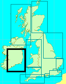
AC 44 Nose of Howth to Ballyquintin Point; AC 633 Skerries Islands; Imray C52 Irish SeaRules & Regulations
NoneHazards
The Skerries are surrounded by drying reefs and off lying rocks; stay well outside them unless you have the large scale chart of them on board (AC 0633-2)Tidal Data Times & Range
Tides are as Balbriggan to the North: HW is HW Dublin – 0020, LW is LW Dublin + 0005; MHWS 4.4m MHWN 3.6 no data for LW, it dries throughoutThis site is designed for slower, roaming broadband connections, like you would get at sea, so it needs JavaScript enabled to expand the text.
General Description
Contacts: Skerries Sailing Club VHF #72 (when racing) tel +353-1-8491233
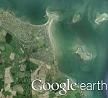
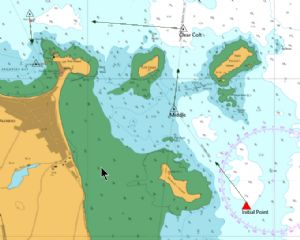
The Skerries is a group of Islands close to the Irish coast to the north of the Nose of Howth. There are three detached islands and a fourth which is connected to the mainland by a narrow isthmus forming a bay to its West & North West. Another small, isolated island (Rockabill) exists a further 2.5 miles out to the ENE but is not considered as part of the Skerries.
The Skerries themselves consist of St Patrick’s Island, Shennick’s Island, Colt Island and Red Island, which is the one connected to the mainland and is more of a promontory than an island. Inshore passage between St Patrick’s Island and Colt Island is possible using AC0633-2 and the bearings shown on that to remain clear of the rocks and the Dthaun spit; the passage between Colt Island and Red Island is more risky as there is a long, unmarked spit pushing out to its SW which dries at LW.
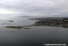
The bay enclosed by the Red Island isthmus provides a sheltered anchorage with good holding in winds from the SW through S to East but it becomes very wild in winds from the West round to NE through North. The bay is a popular anchorage and is pretty well filled with local moorings; there is a pier which forms extra shelter close in but this is largely occupied by fishing vessels and is unlikely to be of any use to the visiting yachtsman. If planning to stop here it’s worth trying to contact the Sailing Club to see if they have a spare mooring you could use, otherwise you will have to drop your pick quite a long way out with the subsequent reduction in shelter and increase in the length of the row ashore.
The village ashore is an attractive place and becoming increasingly popular as a commuter town for Dublin; this has the advantage that there are shops and amenities developing to serve such a community and a railway link with Dublin. The town is much large than shown on the Admiralty chart 0633 and occupies the whole of the shore line as far back as the railway and north west to where the railway closes with the coast. This means that if making an approach after dark you will be met with a fully lit shore and will have difficulty picking out the pierhead light and the PHM off the Cross Rock. It’s worth noting that the safe sector of the pierhead light is red and that it will not keep you clear of unlit moored boats on its southern edge
Approach
Coming from the North is no problem,
....... as you sail in to the bay watch out for the yellow buoys marking the sewage outfall and the red PHM covering the Cross Rock (leave it to port!!). From the South you have several options; you don’t need to go round the outside of the Rockabill but give St Patrick’s Island a 2 1/2 cable offing to the East to clear the rocks off its NE corner. When well clear of that turn to West with a touch of North to clear the Cobb Rocks to the North of Colt Island and make for the PHM off the Cross Rocks and when abeam there turn South in towards the moorings. The locals will undoubtedly pass inside the Cross Rocks PHM but as a visitor it’s a bit on the brave side!
Berthing, Mooring & Anchoring
In all probability you will have to anchor off here unless.....
...... you have made arrangements with the Sailing Club to use one of their moorings. In settled conditions and if you can take the ground there is normally plenty of room near the shore but take account of the weather forecast because if it blows up from the wrong direction you could end up bashing around in the surf.
Facilities
There’s water at the pier and the Sailing Club has showers, toilets and a bar. The town itself abounds with shops and retail outlets.
Eating, Drinking & Entertainment
The Sailing Club bar will be your first port of call after a day’s sailing and they will undoubtedly be able to advise on their favourite pubs and restaurants; you will have plenty of choice for an evening’s run ashore.
There’s a good list of eateries at
http://www.dublintourist.com/directory/eating_out/north_county/skerries/
Links
|

Your Ratings & Comments