You are viewing the expanded version of this Harbour,
for faster browsing
use the regular version here

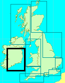
Wexford
Courtesy Flag
Irish TricolourWaypoint
52°19.14N 006°19.39W (Wicklow Bar Buoy SWM)Charts
AC1772 Rosslare Europort & Wexford; SC5621-15A Wexford and Rosslare; Imray C61 St Georges Channel (Wexford Port Plan)Rules & Regulations
None KnownHazards
Narrow navigation channel with changing depths and routing; Off shore shifting banksTidal Data Times & Range
HW is HW Dover – 0450 or HW Cobh + 0130; MHWS 2.0m MHWN 1.5m MLWN 1.0m MLWS 0.5m In the Bay the tidal streams are not strong and flow in and out with the tide but once between the training walls and in the harbour the streams are quite strong reaching 2kts at springs and can be even stronger after prolonged periods of heavy rain (in Ireland??)This site is designed for slower, roaming broadband connections, like you would get at sea, so it needs JavaScript enabled to expand the text.
General Description
Contacts:
Wexford Harbour Boat Club +353 (0)5 3912 2039
There has been a very busy harbour at Wexford for centuries and has been used variously for commercial trade, fishing and, for a period, privateering, (polite word for pirates) on English ships operating on the other side of the St Georges Channel. Wexford has been involved in conflict throughout the centuries against anyone who thought they had a right to govern them either from Dublin or Westminster and have suffered several “sackings” through the ages.
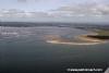
Numerous attempts have been made by various Bodies to improve the access to the harbour but some of those have ended up making the situation worse rather than better. At one stage land reclamation north of Rosslare Point stretched out as far as the ruins which can still be seen on the starboard hand as you navigate the buoyed channel through the bar.
The training walls pushing out into the bay from the harbour were part of one of the attempts to improve the situation hoping to concentrate the outfall from the hinterland and scour a channel but over the years they were allowed to fall into disrepair and lost their effectiveness. Plans are afoot to rebuild the South training wall back above MHWS; at the moment that wall is under water at high tide and needs to be watched out for.
It has to be said that there were vested interests in keeping the access to the harbour difficult; the merchants had invested in shallow draft boats and if the harbour were to be made more accessible they would find themselves in competition with deep draft bottoms and, during the time of the privateering, the shallow passage protected them from the “big guns” of the English Fleet.
We are left today with a viable dock and harbour with an unviable entrance and there is virtually no cargo trade and only a small fleet of vessels harvesting mussels and other shell fish. There are no organised facilities for visiting yachtsmen apart from those offered by the Wexford Boat and Tennis Club, and their club house is the wrong side of the bridge spanning the harbour for any boat with a mast.
This is a pity because Wexford would be a delightful place to visit, especially after a crossing from England; it has all the facilities of a vibrant county town with plenty of shops, restaurants and quality pubs. As it is, as a visitor, you can only get in sensibly during the last two hours of the flood and then only in off shore winds and you don’t need those sorts of restrictions at the end of a longish crossing of the St Georges Channel. Add to that, outbound you are going to have to work out the gamble of whether to peg the rising tide or risk going down on the ebb.
For comprehensive information about the harbour you must take a look at the web site:-
http://www.wexfordharbour.info/
This has the most recent information on the navigation in through the channel along with pages and pages of interest about Wexford. You must also look at their Facebook page where you will see much imagery of recent changes to the channel.
https://www.facebook.com/wexfordharbour.info?ref=stream
It is noticeable that the only buoyage shown on Admiralty charts is the Bar Buoy itself and that is because the channel buoyage has to be constantly moved by the diligent members of the Wexford BC. The soundings on the UKHO charts are woefully out of date being derived from mid Twentieth Century surveys, the most recent one being 1951; this is most obvious when you consider that the present day channel traverses banks which are marked as drying more than a meter above LAT.
For those reasons it is essential that you look at the two websites above; they are well maintained and contain massive amounts of valuable information to be researched in the planning stages of your trip
It is really up to the individual whether to call in here on an Irish Cruise; you can see it as a challenge to be taken or a challenge to be avoided; if you take the challenge make sure you have taken the most recent advice from the Wexford Boat Club or from the HM at Rosslare Harbour. You will also need a reliable echo sounder, a reliable engine and brass cojones.
Approach
Your approach should be made from the Wexford Bar SWM and...
..... to get there you will have to circumnavigate the Lucifer Bank, the Long Bank and Holdens Bed. How you do that depends on where you started from and the weather because some of these banks, although apparently deep enough, have changed since the surveys and in Easterly weather can kick up quite a dangerous sea.
Once you have identified the SWM it’s a matter of buoy hopping your way into Wexford. Do not use any old records of buoy positions from previous years. Both Navionics and Admiralty charts show the deepest water just to the South of Raven Point; in 2015 this was no longer the case and the buoyed channel is almost in the centre of the bay and this remains the case in 2019
They have done a recent survey of the channel and you can access their chart at:-
http://www.wexfordharbour.info/iChart/
This chart is preceded by a very clear warning that it should not be used for navigation; Navionics have copied it into their master chart where the unwary might be tempted to do just that - use it for navigation DON'T.
The advice from everyone is to contact the Wexford Boat Club and/or the Harbour master at Rosslare to find out about the depths in the channel with relation to the existing buoyage and then do not attempt to make a passage inbound in anything other than quiet conditions in good visibility. There are many more PHM than SHM and you should take care to pass close aboard those PHMs.
At the state of the tide you will be making your approach (2 hours before HW – not earlier) you will find that most of the southern training wall is under water but the buoyage keeps you well clear of that. The “Navigation” link on the Wexfordharbour.info website (above) shows the buoyage as it was in the mid summer of 2020 but since then it has changed and you can trace its history over the years.
Berthing, Mooring & Anchoring
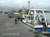
The berths on the town side of the harbour are normally
....... occupied by the mussel dredgers but that is the best place to tie up if you can find a space or arrange to raft, and it is free.
Otherwise you should anchor North of the Ballast bank unless you have managed to arrange the loan of a WBC mooring in that area. If anchoring you would be wise to employ a tripping line.
You can land at the slip on the Northern bank below the bridge or row across to the South side but be aware that the stream runs through here at up to 2kts at springs so unless you have an outboard for your tender that is going to involve a lot of hard work.
Facilities
If alongside the quays on the South Bank you will have access to the town which has all the facilities one would expect including water on the quayside.
The Wexford Boat Club’s clubhouse is just over half a mile above the bridge on the South bank and welcomes visitors; they have a bar and shower facilities which may be used. Many people use their dinghies to get to it, especially if anchored or moored out in the stream; go up on the flood and back on the ebb obviously...
Eating, Drinking & Entertainment
Wexford is a lively tourist destination, good food, good beer and good music. For a comprehensive list try this website.
Links
|

Your Ratings & Comments