You are viewing the expanded version of this Harbour,
for faster browsing
use the regular version here

Southwold Harbour
Courtesy Flag
Flag, Red EnsignWaypoint
SE of Entrance 52:18'.31 N 001:40.9E Track inbound 330(T)Charts
Admiralty, 2695Rules & Regulations
Speed Limit 4 MPH ? No wash. Essential to contact HM before entry on Ch.12Hazards
Entrance Dangerous in Onshore Winds, Very Strong Tidal Flows.Tidal Data Times & Range
Dover -0105 MHWS 2.4m, MHWN 2.1m, MLWN 1.0m, MLWS 0.5m (links)This site is designed for slower, roaming broadband connections, like you would get at sea, so it needs JavaScript enabled to expand the text.
General Description
Southwold is a small harbour with a tricky entrance and some yachting facilities....
lying between the River Ore to the South and Lowestoft to the North.
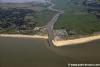
The actual town of Southwold is about a mile north of the harbour and any provisioning will involve a bit of a hike. The harbour itself lies in the River Blyth and entrance involves negotiating a sandbar and coping with strong tidal streams. Immediately past the harbour moorings the way is blocked by a fixed bridge.
East Suffolk council have spent a lot of money here in the last year or so and there have been major improvements and all sections (Approach, Berthing and Facilities) on this page have been updated to reflect those changes. Having said that it must be noted that one of our members was in here in 2016 and was singularly unimpressed (See "Have your say at the bottom)
ED Note. There is also a note from 2022 and it appears that this is still not a very welcoming place for cruising sailors.
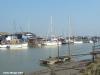
There are now a couple of deep water berths near the Lifeboat Station on the starboard hand after the Knuckle. In addition there is now 80 feet of pontoon outside the Harbour Office just before the Sailing Club.
There are still visitors moorings outside the Sailing Club on Blackshore Quay consisting of timber stagings, and the harbourmaster can provide the necessary fenderboards. These will very much be needed with the ebb attaining speeds of up to 6 knots and possible rafting up to 4 deep, as will copious amounts of rope to arrange shorelines and springs etc.
There is a decent boatyard on the spot (who may also help with moorings are arranged if advance), and very importantly a pub adjacent to the visitors moorings.
At all times you need phone ahead, as the visitors berths can rapidly fill up and there is nowhere else to settle. (No room for anchoring).
Approach
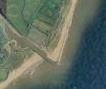
Although perhaps not as daunting as the entrance to the River Ore....
, the entrance to Southwold needs to be treated with the utmost respect by Mariners. The lifeboat station sited in the entrance is not there for no reason at all.
Before planning an entry contact the HM on 01502 724712 24 hours in advance and agin on VHF #12 before entry. This is mandatory
There is a plan of the entry at:-
Southwold-Harbour-Entry-Plan.jpg (1592×1159) (eastsuffolk.gov.uk)
Be advised this plan is not dated and some of the headings and positions in the text don't match - use a heading of 330(T) from the initial entry point.
Sandbanks in and around the entrance are liable to sudden changes after easterly gales, and during strong winds having any East in them entry shouldn't be attempted. The sea can break heavily on the shallows in the approaches with onshore winds. To complicate matters more, the tide can flow out of the entrance at up to 6 kn adding to the turbulence.
Over the last few years there have been changes made to the hinterland drainage which means that currents after rain are slightly stronger than hitherto; as a result there has been more scouring to seaward of the entrance and the depths have been increased since the last Admiralty surveys. The HM here advises us that the minimum depth outside the harbour "is at least a metre"
Keep an eye on the signals displayed from the North pier, if three vertically orientated flashing red lights are shown or two red flags you must not attempt entry.
Obviously entry cannot be made against the ebbing tide, so if the weather conditions are right, it is best to plan your entry to go into on the latter half of the flood tide.
Finding the entrance is not too difficult, the town of Southwold with it's lighthouse lies about a mile to the north. If coming from the South you will have passed the instantly recognisable Sizewell Atomic power station.
There is no buoyage marking the approach to Southwold, and we have provided a safe offing waypoint lying to the south-east of the harbour mouth.
It is required that before a first-time entry that you contact the harbour master on VHF channel 12 or telephone 01502 724712 for up to date pilotage information. (9 AM to 5 PM).
While making your approach be prepared for strong cross tides and once making your run in between the piers look out for "The Knuckle" protruding into the River at the root of the North pier. It has a speed limit sign on it together with a notice board.
As soon as you get level with it you will need to swing hard to starboard to avoid a shallow bank lying directly in your path. Aim directly for the lifeboat station building and skirt closely along the dock wall. Keep well to the starboard side until you enter the River proper, aiming to get more central at the point at which cables cross under the River (marked by noticeboards). Watch out for a small ferry crossing the river around here.
The general track is shown on the Southwold Entry Plan (mentioned above). Bearing in mind you may have a few knots of tide underneath you propelling you forwards, it is necessary to use enough power to maintain steerage way. Tidal eddies encountered will need corrective helm.
March 2022 updated
Berthing, Mooring & Anchoring
Once into the River Blyth you will be moving between timber staging moorings....
.... on either side, with the bulk of them to starboard.
This river is not that wide and, once in, you'll be travelling up quite quickly on the tide; if you have plenty of crew to rig for harbour that's not a problem but if short handed it would be an idea to rig for harbour before shaping a course for the entrance. You'll be coming alongside port side to so plenty of fenders for that side but don't forget to keep some for the other side as you are likely to be rafted on.
Firstly contact the HM VHF#12 (or tel 01502 724712) to ascertain where he wants you to tie up. There are now several choices as has been mentioned;
1. Some deep water moorings for larger vessels are available just past the Lifeboat station on the Quay
2. There is now an 80 foot pontoon outside the HM's Office.
3. The pontoon on the South bank opposite the HMs Office (but be aware of the lack of services there and the walk to the facilities.)
Which ever you go to,you'll have to turn your vessel into the tide once you identify them.
Be wary if you are being swept up the river by a strong side... the fixed footbridge will be looming and you do not want to be ignominiously pinned against it. Right opposite the visitors moorings is a patch of riverbank devoid of stagings. The creative skipper could push the nose of his vessel into the mud on his port side, and let the rapidly flooding tide swing the stern of the boat around. Now facing into the tide and under perfect control the boat could be allowed to move backwards, using forward nudges to maintain steerage.....hmm sounds good on paper. Tried it once elsewhere out of necessity and it worked for me...
In 2022 it will cost £26.00 per night for a 20ft to 30ft or £32.00 a night for 30ft to 40ft boat with an additional charge of £4.30 per day for shore power
Once the boat is safely tied up drag the skipper over to The Harbour Inn, and let him down a pint of Adnams to soothe his frayed nerves....
Facilities
Water is available at the stagings, and electricity can be rigged by arrangement with the harbour master. There is also water and shore power on the new pontoon. The shore power is charged at £4.30 a night
There are new showers and toilets (complimentary) in the HM's Office but only available when the office is open (so check for the early morning commune with nature)
Bad News May 2022 Those toilets and showers are U/S as at May and for the time being visitors have to use the camp site which is half a mile away near the harbour entrance.
Showers and toilets are also available at a caravan site that you passed on the way in to starboard. You will need the mooring receipt to access these.
Otherwise the Southwold Sailing Club on the Quay may be able to help visiting yachtsman:
The harbour can now supply both white and red diesel
Bottled gas and chandlery are available at the boatyard, who may also be able to help out with repairs/storage/hardstanding etc.
Various other specialists can be found in the area, check the directory.
Any kind of provisioning will involve a trip to Southwold town, which is about a mile away. Here you will find a good supply of shops and a couple of banks.
Public transport from Southwold is not brilliant, but there is a regular bus service to Halesworth which has a branch railway connecting with Lowestoft and Ipswich. Road connections are good.
Trailer Sailor's will find the slipway right next to the Harbour Master's office, and it is available at all of the tidal range for small boats. Harbour dues of £4.60 are payable, and there is a waterskiing area upstream. Get instructions from the harbour master about the areas you can speed in (under the bridge).
More Info
This was the latest order in force in 2019 and it was unchanged from the same one in 2009. Note that the Waveney council is now joined with the East Suffolk Council so all reference to the Waveney website should be ignored.
SOUTHWOLD HARBOUR AUTHORITY
NOTICE TO HARBOUR USERS. NO. 7 OF 2019
NOTICE TO SKIPPERS ENTERING THE HARBOUR
1. All vessels using Southwold Harbour are to comply with the International Regulations for Preventing Collisions at Sea (COLREGS). In particular vessels shall at all times proceed at a safe speed. The speed limit in the Harbour is dead slow. This is the minimum speed at which steerage and progress can be maintained.
2. There is a sand bar outside the Harbour entrance that extends NE of the North pier that shifts. Visitors to the Harbour MUST call the Harbour Master on VHF Channel 12 or telephone 01502 724712 before entering for information. The Harbour Master’s Office is manned from 0900 - 1600 during the Winter months and from 8 am – 8 pm during the Summer months. Even though the Harbour Master may provide information the Skipper remains responsible for the conduct and safe navigation of his vessel at all times.
3. Please refer to the current recommended entry plan, which is posted at the Harbour Office, Notice Boards and also on the Waveney District Council web site at www.waveney.gov.uk
4. Beware of the shallows on the South side of the River opposite the RNLI station. Keep close to the wall on the starboard side.
5. The minimum depth in the Channel is prone to changes please call 01502 724712.
6. When nearing and passing the ferry do so at very slow speed and with extreme caution. See Notice to Harbour Users No 5 / 2009.
7. Mooring on the North Wall is RESTRICTED, except with express permission of the Harbour Master.
8. The tide at the visitors’ berths is about an hour later than the entrance.
9. Visitors may be rafted at the visitors’ moorings. The ebb tide runs at up to 6 knots. Shore lines will be required.
10. There is a turning area adjacent the visitors’ moorings. Large vessels should only swing in this turning area.
11. Upstream of the visitors’ moorings is a bridge, which is unlit. Caution is required in the dark.
12. Harbour Dues or Mooring fees are payable to the Harbour Authority by every vessel using the harbour regardless of size.
13. All users MUST report to the Harbour Master on arrival.
Mr. Peter Simmons
Harbour Master
Harbour Master’s Office
Blackshore
Southwold IP18 6TA
The "entry plan" available on the Waveney website (above) was undated when we checked in April 2019. If you do access it, check the date and view accordingly; do not ignore the instruction to contact the HM on Channel 12 before entry.
History
History
Southwold was mentioned in the Domesday Book as an important fishing port, and it received a town charter from Henry VII in 1489. Over the following centuries a shingle bar built up across the harbour mouth, preventing the town becoming a major port.
Southwold was the home of a number of Puritan emigrants to the Massachusetts Bay Colony in the early seventeenth century. Richard Ibrook, born in Southwold and a former bailiff of the town, emigrated to Hingham, Massachusetts, along with Rev. Peter Hobart, son of Edmund Hobart of Hingham, Norfolk. Rev. Hobart was formerly an assistant vicar of Southwold's St. Edmunds Church after his graduation from Magdalene College, Cambridge. (Hobart married as his second wife in America Rebecca Ibrook, daughter of his fellow Puritan Richard Ibrook.) The immigrants to Hingham were led by Robert Peck, vicar of St. Andrews' Church in Hingham and a native of Beccles, Suffolk.
In 1659 a fire devastated most of the town and damaged St Edmunds Church, whose original structure dated from the 12th century. The fire created a number of open spaces within the town which were never rebuilt. Today these greens, and the restriction of expansion because of the surrounding marshes, have preserved its genteel appearance.
On the green just above the beach, descriptively named Gun Hill, the six eighteen-pounder cannon commemorate the Battle of Sole Bay, fought in 1672 between English and French fleets on one side and the Dutch (under Michiel de Ruyter) on the other. The battle was bloody but indecisive and many bodies were washed ashore. Southwold Museum has a collection of mementos of the event.
It has always been held that the cannons were captured from the Scots at Culloden and given to the town by the Duke of Cumberland but they are much larger than those used in that campaign.
Lighthouse
Southwold lighthouse was constructed in 1887 by Trinity House. It stands as a landmark in the centre of the town. It replaced three local lighthouses which were under serious threat from coastal erosion. It began operation in 1890 and was electrified and de-manned in 1938. The lighthouse is unusual in that the light itself is switched on and off in sequence (four flashes every 20 seconds), rather than the more usual lenses to create a rotating beam. Trinity House organises visits during the summer.
Southwold Harbour
Southwold Harbour lies south of the town on the River Blyth. It extends from the river mouth to nearly a mile upstream and serves mainly fishing and small pleasure boats.
Situated at the seaward end of the harbour are the RNLI Lifeboat Shed, and the Alfred Corry Museum. Housed in the former Cromer lifeboat shed, the latter is home to the former Southwold lifeboat "Alfred Corry", which was in service from 1893 to 1918. The boat is currently being restored to her original state.
The river can be crossed on foot or on a bicycle by a public footbridge (partly the old railway bridge) close to The Harbour Inn giving access to the nearby village of Walberswick. This bridge, known as the Bailey Bridge, is based upon the footings of the original railway bridge. It replaced that bridge, which contained a swinging section to allow the passage of wherries and other shipping, and which was largely demolished at the start of the Second World War as a precaution when German invasion was expected.
Towards the mouth of the River Blyth, a rowing boat ferry service runs between the Walberswick and Southwold banks. The ferry has been operated by the same family since the 1920s, when it was a chain ferry that could take cars. The chain ferry ceased working in 1941, but some small vestiges remain at the Walberswick slipway.
The beach is a combination of sand and shingle. In 2005/6 it was further protected by a coastal management scheme which includes beach nourishment, new groynes on the south side of the pier and riprap to the north.
It is overlooked by brightly painted beach huts.
The text on this HISTORY page is covered by the following licence
http://en.wikipedia.org/wiki/Wikipedia:Text_of_the_GNU_Free_Documentation_License
Eating, Drinking & Entertainment
The facilities on the spot for the hungry, thirsty sailor consist of the already mentioned pub (which serves food, thankfully), and tea rooms open day times only.
An expedition could be made to the peculiar sounding "Warblerswick" village on the other side (South) of the River. Either hike it round crossing via the bridge and come back on yourself.... or if you're lazy get the ferry man to run you across. Here you will find further tea rooms and a couple of pubs.
If these just won't do, you will have to make the trek to Southwold town where you will find a reasonable selection of pubs and restaurants, with the Blythe Hotel on Station Road getting a very high rating. check the links below:
Pubs:
http://www.beerintheevening.com/pubs/results.shtml/el/Southwold%3BSuffolk/
Eating Out:
Links
|

Your Ratings & Comments
i want to thank both of them for all the help they have given me,
can anybody give me any info about fishing not to far out
many thanks
boat lucky bee
graham