

Harbour Information (use the  icons to find out more)

Amble (Warkworth Harbour)
Your Comments: 12 Read or add your comments
Courtesy Flag
Flag, Red EnsignWaypoint
Off entrance 55:20'.4 N 001:34'.1 W .Charts
Admiralty 1627Rules & Regulations
4 mph speed limit in HarbourHazards
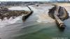
AVOID 55:20'.536N 001:33'.567W Pan Bush, breaking seas / shallows near Entrance. The sand bar at the entrance is a movable feast and can be found on the starboard or port hand as you come in; check with the harbour before starting your approach.Tidal Data Times & Range
HW Dover +0412 MHWS 5.0m MHWN 3.9m MLWN 1.9 MLWS 0.8m (links)This site is designed for slower, roaming broadband connections, like you would get at sea, so it needs JavaScript enabled to expand the text.
General Description
Contacts
Harbour Master 01665 710306 VHF #14 (office hours only)
Marina 01665 712168 VHF #80
Amble, sometimes known by its other name Warkworth Harbour.... ... read more
Approach
Trinity House, a good few years back, removed all the coastal buoyage from the Northumberland coast,.... ... read more
Berthing, Mooring & Anchoring
The first length of quay you come across (Broomhill Quay) on your port side...... ... read more
Your Ratings & Comments
12 comments
Up date May 2023
Written by Don Thomson 3 | 18th May 2023
The channel here still wanders at the entrance. At the momenmt it's on the South side but could change next week. Call the HM and keep an eye on the acho sounder.
Update May 2022
Written by Don Thomson 3 | 31st May 2022
I reviewed these notes at the end of May 2022. I had a natter with HM about entrance bar and he says that the fishermen are coming in on the Northern side of the entrance and then making their way across to the left hand bend in the Half tide wave barrier. The best advice is to give him a call on 14 and then come in after half tide on the flood! Prices have changed but it sounds a nice place to call in.
Visit May 2022 - Still great
Written by julianc | 2nd May 2022
Deeper water in the river is definately on the normal south side. No difficulties entering or leaving at reasonable states of the tide.
Marina well set-up for late arrival, early departure. Welcoming packs in blue box on visitor's pontoon with fobs for access.
Harbourside restaurants continue to be excellent.
Marina well set-up for late arrival, early departure. Welcoming packs in blue box on visitor's pontoon with fobs for access.
Harbourside restaurants continue to be excellent.
1 of 1 people found this helpful
UPDATE SPRING 2021
Written by Don Thomson 3 | 30th Apr 2021
I reviewed these notes at the end of April 2021. The harbour no longer offers the Broomhill quay for mooring so make for the marina. The deep water is reported to be on the North side of the entrance but is known to shift. Prices in the marina have changed.
Update Spring 2019
Written by Don Thomson 3 | 12th Apr 2019
I reviewed these notes in April 2019. We received reports last summer (2018) that the sand bar at the entrance had moved over to the South side. We carry a warning that this is always a possibility. Other than that, prices have gone up, I've updated the chart and obtained a chartlet of the layout of the marina.
1 of 1 people found this helpful
glen coe
Written by mark37snuggler | 17th Dec 2017
I've been living aboard on glen coe in Amble Marina now since October 2017 .I recommend Amble to any one looking for a safe mooring long term or just short term . I'm here till spring . before setting off again . around Scotland . and heading back for Argyll .the marina is fully fitted out with a 40ton hoist and good local facilities with in a min walk .
UP DATE MARCH 2017
Written by Don Thomson | 28th Mar 2017
These notes were reviewed by Don in March 2017. The work on Broomhill Quay is complete and it looks pretty topside friendly - they will take boats here but it is fairly unusual as most boats opt for the marina where the facilities are much better. The note below that the inside passage is "easy" may be the case but Barbados Billy is fairly experienced; if in any doubt go round the long way!!
1 of 1 people found this helpful
Amble is just great.
Written by Barbados Billy | 25th Sep 2016
After a bash up the coast it is always nice to reach Amble. I have been a few times now and it is always a good experience. The staff are really helpful with advice and where to get stuff they haven't got. I needed some new batteries and the local motor factor delivered them to the marina within the hour. The chandlery is perhaps not a well stocked at it once was but that is the way now with online shopping. Food is a short walk away and there are a few pubs to choose from. Access is easy with good anchorages if you want or if waiting for the tide on the bar. In good weather the inside channel is easy but just mind the many pot markers.
Update 2015
Written by dononshytalk | 9th Mar 2015
These notes were reviewed by Don in March 2015 and the marina prices updated, otherwise there have been no changes
Update 2013
Written by dononshytalk | 8th Apr 2013
These notes were reviewed by Don T on the 8th April 2013. The work on the damaged quay wall is due to be completed in time for the 2013 season and the marina prices have been updated for that season.
View all 12 feedback items

© visitMyHarbour.com | website design created by Black Culm Ltd