You are viewing the expanded version of this Harbour,
for faster browsing
use the regular version here

Bridlington Harbour
Courtesy Flag
Flag, Red EnsignWaypoint
N Pierhead (liable to changes) 54:04'.77 N 000:11'.19 WCharts
Admiralty 1882Rules & Regulations
UnknownHazards
Harbour Dries, Unsafe entry in strong onshore conditions.Tidal Data Times & Range
Tides +0553 Dover MHWS 6.1m, MHWN 4.7m, MLWN 2.3m, MLWS 1.1mThis site is designed for slower, roaming broadband connections, like you would get at sea, so it needs JavaScript enabled to expand the text.
General Description
Bridlington is a smallish harbour mainly catering for commercial and leisure fishing.....
..... tripper boats and a few yachts. It dries to soft mud, and at present visitors berths are available on the new pontoons or against the South Quay.
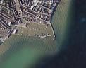
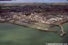
The site is an obvious one for a harbour, built as it is in the lee of Flamborough Head. Natural land features give it protection from the South West round to just east of North. The shallow Smithic Bank lying just to the east provides some protection from the sea when the winds are in that direction. Goods have been exported from this harbour since mediaeval times, but it took its present form in 1848.
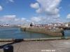
There have been plans here for quite a few years to expand the harbour and the general plans for that can be seen in our photo gallery. There have been various objections to those plans from "interest groups" and at the time of writing (April 2013) those major plans are on hold but very much in the forefront of the Harbour Commissioners' thinking. For the moment no one expects there to be very much movement on that front in the immediate future but the good news is that, as an interim measure, they have cleared away the old "cradles" and replaced them with drying, fully serviced pontoons. The new pontoons are shown in the new picture in our gallery and a chartlet in our "Nav Images". Fin keeled boats will still be able to lie against the South Quay but there is no longer the option of lying in a cradle in the harbour.
Marina or not, Bridlington will remain untenable in strong onshore weather from the East and south-east, when breaking seas can develop on the Smithic shoal and harbour entry impossible. Furthermore the harbour and even the approach can dry out at LWS.
Having said that, with the introduction of the serviced pontoons, "Brid" has become a much more convenient place to stop on a coastal cruise. Mind you, you have to remember that , when Northbound, you are running with the ebb, the nearest stopping place to the South is Spurn Head 35 miles away and, when you look at the lay of the land, it is not surprising to find some significant back eddies in Bridlington Bay. (see "More Information" section below)
The town is a popular holiday centre, and all good-sized town facilities will be found including banks, shops and transport.
There is diesel and there are heavy lifting capabilities with all kinds of repairs and chandlery available on hand.
The Royal Yorkshire Yacht Club overlooks the harbour and is welcoming to visiting yachtsman.
Approach
The immediate approaches to Bridlington Harbour are protected by Flamborough Head.....
..... with the wind anywhere from south clockwise through to north-east. The approaches are clear of danger other than the Smithic Sands which in normal conditions can be sailed straight over, with the least depths of over 2.5 m at CD.
When the wind pipes up strong from the East or Southeast the seas can break in this area and approaching Bridlington Harbour becomes a dangerous proposition. Visiting yachtsman and motorboaters are advised to steer clear in these situations.
Full pilotage details:
If approaching from the North it is wise to give Flamborough Head a berth of at least 2 miles in wind against tide situations, due to overfalls.
Approach from the South is straightforward with the seabed shelving gently, while the approach from the East is all clear.
On the chart the harbour is shown as completely drying at CD, but in practice especially at neaps, there is usually some water in the entrance and around the Fish Quay. An unstable drying sandbank, The Canch, lurks just outside the entrance.
JerryG mentions the new block of flats overlooking the harbour on the Western side. They stand well above any other builsing at the moment and are shown on the UKHO chart and are a good way of identifying the harbour on the generally low lying shore.
In practice boat drawing about 1.5 m can enter three hours either side of high water during springs, with even more leeway during neaps.
Harbour Signals
During the hours of darkness, navigation lights at the end of the North Pier denote the following:
GREEN Light - Depth of water less than 9 feet in harbour entrance RED Light - Depth of water more than 9 feet in harbour entrance
In the hours of daylight, a red flag flying near the end of the South Pier denotes that there is more than 9 feet of water in the harbour entrance.
As a sailor this is confusing but we are assured by the harbour that it is correct and iaw Trinity House requirements.
Visitors are asked to call the Harbour on VHF Channel 16 and Working Channel 12 prior to arrival for berthing allocation. Other contact details are as follows:
Office:
Open 0730 to 1700. Harbour Staff (South Pier Office) can be contacted on VHF 16 (or 12 outside hours). 01262 670148 (watchkeeper) 24hrs.
The harbour is run as a Trust, with 22 commissioners. The harbourmaster is in charge of day-to-day operations. See the new harbour website:
http://www.bridlingtonharbour.com
Berthing, Mooring & Anchoring
Berth as directed by the harbour master. If.........
.......you can take the ground you may expect to be put on one of the new pontoons (much to be preferred as there is water and shore power on those) otherwise you'll be put on the South Quay,past the fuel and the crane. The bottom is soft mud, and keel boats can lean against the wall if necessary. The depths available against the wall reduce the further you get into the harbour past the crane.

They are charging the same in 2022 as 2020 which is £20.00 + VAT for up to 10 metres and £30.00 +VAT for over 10 metres per night.
The berths are very convenient for the town and the yacht club.
It is worth noting the remarks in the "Have your say" section at the bottom. Barbados Billy anchored out side the harbour "I tucked right into the corner of the bay north of the harbour inside the sailing marks" Worth remembering.
Facilities
There is water and shore power on the pontoons (though it is uncertain whether you will need your own hose)
Apart from on the pontoons, water is available alongside by arrangement with the harbour master. It is located on the South Pier near the fishing landing davit. Electricity is only available on the pontoons or on the Quay by arrangement and the supply is near the crane,
There are security arrangements in the harbour with CCTV and 24-hour patrols.
The harbour master makes available weather forecasts and tidal data at his office on the North side of the harbour. He is also the one to arrange diesel fuel for your boat. Bottled Gas is available (01262 679797 AKM.) but it is a fair old hike out of town.
Engine servicing and repairs can be handled locally and there is a chandler at the West side of the harbour.
The harbour authorities operate the 5 tonne crane on the South pier and also a 70 tonne travel lift.
Visiting yachtsman are able to use the premises and bar of the Royal Yorkshire Yacht Club which overlooks the harbour on the West side. The club is open seven days a week in the summer and showers are available for visitors during the daytimes, and by arrangement at other times. Telephone them on 01262 672041, a link to their website is provided below:
http://www.ryyc.org.uk/ryyc_home.htm
Trailer Sailers can launch from the South Shore, Bridlington.
The terms and conditions for this are constantly changing visit Boat launching (eastriding.gov.uk) as a starting point
Transport wise Bridlington railway station connects with Hull and Scarborough, and with the population in the area numbering over 30,000 (somewhat more in the summer) you will find all the town facilities you are likely to need.
Supermarkets, banks, shops of all varieties... these will all be found in the main town which lies just to the North of the harbour (nearby, not a desperate hike).
More Info
The "hook" of land poking out into the North Sea at Flamborough Head is the classic place to expect to find back eddies as the land acts like a spoon stuck out into the north/south tidal stream. Thus, when the stream is north bound it gets caught by Flamborough and you get a south bound eddy close inshore and vice versa for when the south stream eddies back into Brid Bay and gives a north bound back eddy late on into the flood cycle. Thus It is local knowledge that you can depart Brid as much as 2 hours before HW and catch a north bound eddy between the South Landing and Flamborough Head. As you would expect, where this eddy meets with the south bound stream again, you get considerable tidal disturbance to the NE of the North Smethwick Buoy so you should navigate close inshore of that buoy whilst maintaining visual contact with the top of the Flamborough head lighthouse (so you don't get too close!!)
Conversely, if you are belting south and coming round Flamborough Head making for Brid on the last of the flood - go wide or you'll run slap in to that eddy and take a bit longer for the last five miles than you planned for!!
History
Bridlington is a seaside resort and minor seaport on the North Sea coast. It lies just south of the promontory of Flamborough Head. It is served by Bridlington railway station which is on the Yorkshire Coast Line that runs between Hull and Scarborough.
Bridlington sits on the Holderness Coast, an area which is known to have the highest erosion rates in Europe. Southward the coast becomes low, but northward it is steep and very fine, where the great spur of Flamborough Head projects eastward. The sea front is protected by a sea wall and a wide beach encouraged by wooden groynes which trap the sand. The beaches are part of a large deposit of Smithic Sand which stretches out into the bay in sand banks which are an important habitat for many marine species.
The civil parish is formed by the town of Bridlington and the villages of Bessingby and Sewerby. According to the 2001 UK census, Bridlington parish had a population of 33,837.
The town is divided into two parts:
* The Old Town, the ancient market town (once known as Burlington) lying about a mile from the coast. The old town contains the historic site of the town’s market and The Priory Church of St Mary, on the site of an Augustinian Priory which was dissolved by Henry VIII when the last prior was executed for taking part in the Pilgrimage of Grace .
* Bridlington Quay, which is the home of the tourist area and the harbour. It has excellent sea-bathing, and the parade and ornamental gardens provide pleasant promenades. The Bridlington Harbour is the key feature of the Quay, which is enclosed by two stone piers. Recently extensive works have been carried out along the sea front and after some struggle with planning permission, a 'London Eye'-style wheel has been built.
History
The origins of the inhabitation of Bridlington area are unknown but can be traced back to ancient times. The nearby Dane's Dyke, a 2.5-mile (4.0 km) long manmade dyke dates back to the Bronze Age. Also some writers believe that Bridlington was a site of a Roman station as a Roman Road can be traced into the town and Roman coins have been found in the town.
The first written evidence on the town can be found in the Domesday Book . It records that ‘Bretlinton’ was the head of the Huntow Hundred and was held by Earl Morcar before they passed into the hands of William I of England by the forfeiture . The survey also records the effect of the Harrying of the North as the annual value of the land had decreased from 32 pounds in the time of Edward the Confessor to 8 shillings at the time of the survey and comprised:
“two villeins, and one socman with one carucate and a half. The rest is waste.”
The land was given to Gilbert de Gant, nephew of the King, in 1027. His eldest son, Walter de Gant, later founded an Augustinian priory on the land in 1133 which was confirmed by King Henry I in a Charter. Several succeeding kings confirmed and extended Walter de Gaunt's gift: King Stephen granting in addition the right to have a port; King John granted the prior permission to hold a weekly market and an annual fair in 1200; and Henry VI granted permission for three annual fairs on the Nativity of Mary, and Deposition of and the Translation of St. John of Bridlington in 1446. Also in 1415, Henry V visited the priory to give thanks for victory at the Battle of Agincourt. The town began to be developed around the site of the priory as it grew in importance and size.
After the Dissolution of the monasteries the manor remained with the crown until 1624 when Charles I granted it to Sir John Ramsey, who had recently been created the Earl of Holderness. In 1633, Sir George Ramsey sold the manor to 13 inhabitants of the town on behalf of all the tenants of the manor. In May 1636, a deed was drawn up empowering the 13 men as Lords Feoffees or trust holders of the Manor of Bridlington.
In 1643 Queen Henrietta Maria landed at Bridlington with troops to support the Royalist cause in the English Civil War before going on to York which became her head quarters.
From early in the history of the town, a small fishing port grew up near the coast, later known as Bridlington Quay. After the discovery of a chalybeate spring, the Quay developed in the 19th century to become a a Seaside resort. Bridlington's first hotel was opened in 1805 and it soon became a popular holiday resort for industrial workers from West Yorkshire. The railway station opened on 6 October 1846 between the Quay and the historic town. The area around the new station was developed and the two areas of the town were brought together. Bridlington's popularity has declined with the industrial north and the popularity of cheap foreign holidays. In its heyday it was a leading resort with a nationally-famous dance venue at The Spa, and many famous entertainers have appeared in the town.
The following link gives a more detailed history of the harbour:
http://www.thornton1.freeserve.co.uk/harbour.htm
The text on this HISTORY page is covered by the following licence
http://en.wikipedia.org/wiki/Wikipedia:Text_of_the_GNU_Free_Documentation_License
Eating, Drinking & Entertainment
The main town is just to the north of the harbour, and here you will find a good selection of pubs and restaurants to choose from..... ranging from fish and chips upwards. This is a holiday centre and if berthed in the harbour at Bridlington you won't be disappointed by the choices available.
Many yachtsmen will make straight for the welcoming Royal Yorkshire Yacht Club right on the harbour...
Otherwise check out the links below for more ideas:
Pubs:
http://www.beerintheevening.com/pubs/results.shtml/el/Bridlington%3BEast%20Yorkshire/
Restaurants:
Restaurants & Places to Eat in Bridlington 2021 - Tripadvisor
Links
|

Got a comment to make about Bridlington Harbour ? Have you found this coverage helpful ? HAVE YOUR SAY (your email address will always be kept private)
Your Ratings & Comments
View all 11 feedback items