

Harbour Information (use the  icons to find out more)

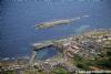
Craster Harbour and Anchorage
Your Comments: 8 Read or add your comments
Courtesy Flag
Flag, Red EnsignWaypoint
Approach from East, between the Carrs 55:28'.44N 001.35'.21 WCharts
Admiralty 156Rules & Regulations
UnknownHazards
Rocky Ledges, see ext. Harbour DriesTidal Data Times & Range
Approx Dover +0350This site is designed for slower, roaming broadband connections, like you would get at sea, so it needs JavaScript enabled to expand the text.
General Description
Craster could be useful stop if passage making North or South down this coast. ... read more
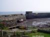
Berthing, Mooring & Anchoring
For anchoring probably the best spot is between the Carrs and off the harbour entrance in over 3 m at low water. ... read more
Your Ratings & Comments
8 comments
Dive Boats are not welcome at this harbour
Written by Phil D | 31st Jul 2023
The Harbourmaster has banned all Dive Boats from this harbour and will robustly refuse entry.
Update June 2022
Written by Don Thomson 3 | 7th Jun 2022
No changes
UPDATE SPRING 2021
Written by Don Thomson 3 | 3rd May 2021
No Changes
A delightful villlage, but very limited anchorage/mooring
Written by Sadoldsamurai | 1st Feb 2020
I row with the Craster Coastal rowing club.
There is currently a freshwater tap across the road, and this (with an extension hose) can feed another hose which runs under the road through the stream culvert.
The Jolly Fisherman pub, 50 m from the harbour serves excellent beer and meals, particularly fish based.
Offshore winds are common, and because of the location of the Carrs there is frequently dirty water at the entrance.
Update Spring 2019
Written by Don Thomson 3 | 15th Apr 2019
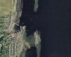
These notes were reviewed in April 2019. I've added a contact number and noted that there is not a fresh water tap on the wall. Charts for this harbour are non-existent but if you use the GE satellite picture the extent and position of the reefs outside can be judged.
0 of 1 people found this helpful
UP DATE MARCH 2017
Written by Don Thomson | 29th Mar 2017
Nothing has been changed
Update 2015
Written by dononshytalk | 9th Mar 2015
These notes were reviewed by Don in March 2015. No changes
1 of 1 people found this helpful
Update 2013
Written by dononshytalk | 8th Apr 2013
These notes were reviewed by Don T on the 8th April 2013. Nothing has changed but recent contact with a sailor who sails these waters indicates that the local fraternity do not consider this (or any of the other anchorages between Amble and Eyemouth, mentioned in some pilot books) as viable for on-passage breaks.

© visitMyHarbour.com | website design created by Black Culm Ltd