You are viewing the expanded version of this Harbour,
for faster browsing
use the regular version here

Herne Bay
Courtesy Flag
Flag, Red EnsignWaypoint
Breakwater End 51:22'.438 N, 001:07'.212 ECharts
Admiralty 1607, SC5606Rules & Regulations
8 Knts Speed limit in marked area off the shore.Hazards
Approach Dries, Harbour Dries, Exposed to W, Soft Mud Bottom.Tidal Data Times & Range
HW Dover +0120 MHWS 5.4, MHWN 4.3m, MLWN 1.5m, MLWS 0.6m (links)This site is designed for slower, roaming broadband connections, like you would get at sea, so it needs JavaScript enabled to expand the text.
General Description
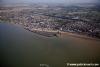
Herne Bay "harbour" is formed by a breakwater made of piled up rock...
... and it's purpose is flood defence for the town.(Locally known as Neptunes Arm). Strong winds from the north coupled with high spring tides can see wave tops slopping over the breakwater. Although the western entrance has a pier structure, this wouldn't provide an enormous amount of protection in strong westerlies.
The breakwater protects a very useful launching ramp which gets much use for speedboats etc.
The whole arrangement forms a long thin harbour, the bottom of which is gloopy mud laying over a base of clay. Warning notices seen in the photo gallery running parallel to and just off the beach marked the limits of the mud. Therefore this harbour could be useful for small boats able to take the ground such as bilge keelers, centreboarders, and POSSIBLY shallow long keelers. It is patently unsuitable for deep fin keeled craft, and there is nowhere suitable to lean your boat against to dry it out.
There are no facilities, no available moorings, but just about enough room for a small boat to anchor. Getting ashore by dinghy would be possible 2 to 3 hours either side of high water, walking ashore across the mud would be crazy.
Once ashore the town can fulfil all day-to-day needs.
Approach
Approach is normally made from the North across shoaling water....
.... some of which at CD has considerably less than 1 m over it. Tidal calculations need to be done carefully. The entrance can be recognised from a distance off by a conspicuous block of flats. Five miles off Herne Bay lies a very conspicious "wind farm" development, but it's beyond the scope of this article to deal with pilotage for the Thames Estuary.
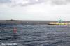
Closer in your you will see lying to the NNW of the harbour what is called on the chart a "landing stage". This is the remaining end of what was once a rather long pier and is very conspicious. It is lit at night (Q.18m4M) The middle parts of the pier have been swept away but the stumpy fragment of it's beginning forms the western entrance of the harbour. It now has a building on it. This is also lit with two fixed green vertically orientated lights. This can be seen in the photo gallery.
The end of the stone breakwater ((vert)2F.R) is left to port, the remains of the pier left well to starboard and the best water is found close to the breakwater.
There is an 8 Kt speed limit inshore and its extremity is marked by yellow buoys.
Berthing, Mooring & Anchoring
Anchor where you can, probably just within the entrance.
It makes sense to buoy the anchor in case it fouls a mooring. At weekends in the summer be prepared for lots of comings and goings of small boats launching and recovering from the ramp at the eastern end of the harbour.
There is no resident harbourmaster as such, the authority is the local council who also control nearby Whitstable Harbour. The HM there is on 01227 274086. There are likely to be council employees around in the season controlling the slipway...
Facilities
No facilities available for visiting yachtsman. It is possible to get ashore in the dinghy a good few hours either side of high water by landing on the wide slipway.
The town is able to provide all the expected day-to-day facilities including a large supermarket, banks with cashpoints and all the normal High Street names.
For the trailer sailer There are two ramps, one leading directly into the harbour and the other to the sea. Access is available at about half the tidal range and although the slipways are free there are council officials manning them during the summer. Car and trailer parking nearby at £4. The place is jetski friendly and popular with speedboats.
Outside of the 8 kn speed limit area as marked by yellow buoys you can zoom away to your hearts content.... just be aware that at low water the shallows extend quite a way out.
There is a sailing club here mainly concerned with dinghies, and a link to their website is provided below:
http://www.hernebaysailingclub.co.uk/
Transport connections are good, with the railway station being on the main line to London.
More Info
If passage making and needing to wait for a fair tide/breeze, maybe far less necessary in these days of reliable diesel auxiliaries, there are some options off the North Kent coast.
In particular it is possible to find anchorages in and around the Margate Sands area, where you can lay out of the main tidal stream and get some kind of shelter from the drying banks.
So if Whitstable, Herne Bay and Margate hold no charms for you being in a deeper draft craft, in settled weather it is possible to anchor off.
For some idea of the best spots refer to the approach chart for Margate and Herne Bay
Herne Bay Coastwatch
Our VHF Working Channel is channel 65, manned by Qualified VHF RYA Licensed Operators so feel free to call us on this channel for up to date weather\local conditions or any other Nautical items we can help or assist you with.
We man a Listening Watch on all channels from our Watch Station which is open between 09:00 - 1700 hours during the summer and 09:00 until 16:30 in the winter time. We are here to assist you
History
Herne Bay is a seaside town in Kent, South East England, with a population of 35,188. On the south coast of the Thames Estuary, it is 7 miles (11 km) north of Canterbury and 1 mile (2 km) east of Whitstable. It neighbours the ancient villages of Herne and Reculver and is part of the City of Canterbury local government district. Herne Bay's seafront is home to the world's first freestanding purpose-built clock tower, built in 1837; until 1978, the town had the second-longest pier in the United Kingdom.
The town began as a small shipping community, receiving goods and passengers from London en route to Canterbury and Dover. The town rose to prominence as a seaside resort during the early 19th century after the building of a pleasure pier and promenade by a group of London investors, and reached its heyday in the late Victorian era. Its popularity as a holiday destination has declined over the past decades, due to the increase in foreign travel and regular flooding that has prevented the town's redevelopment.
History
The town of Herne Bay derived its name from the neighbouring village of Herne, two kilometres inland from the bay. The word herne, meaning a place on a corner of land, evolved from the Old English hyrne, meaning corner. The village was first recorded in around 1100 as Hyrnan. The corner may relate to the sharp turn in the Roman Road between Canterbury and Reculver at Herne.
One of the oldest buildings in Herne Bay is the late 18th-century inn, The Ship, which served as the focal point for the small shipping and farming community which first inhabited the town. During this time, passenger and cargo boats regularly ran between Herne Bay and London, and boats carrying coal ran from Newcastle. From Herne there was easy access by road to the city of Canterbury, or to Dover, where further passage by boat could then be obtained across the English Channel to France.
During the early 1800s, a smugglers' gang operated from the town. The gang were regularly involved in a series of fights with the preventive services until finally being overpowered in the 1820s. In the 1830s, a group of London investors, who recognised Herne Bay's potential as a seaside resort, built a wooden pier and a promenade on the town's seafront. This and the subsequent building of a railway station led to the rapid expansion of the town; between 1831 and 1841 the town's population grew from 1,876 to 3,041. The London businessmen intended to rename the town St Augustine's, but the name was unpopular with residents and the "Herne Bay" remained. In 1833, an Act of Parliament established Herne Bay and Herne as separate towns.
During the 1840s, steamboats began running between Herne Bay and London. There was a type of beach boat unique to Herne Bay and nearby Thanet, known as the Thanet wherry, a narrow pulling boat about 18 feet (5 m) long. These boats were mainly used for fishing; however, with the advent of tourism and the decline of fishing, they became mainly used for pleasure trips. A document dated 1840 records the town as having the following schools, all of which are now defunct: Haddington boarding school, Oxenden House, British School, Prospect Place and Herne Street school.[8] The village of Herne was often called Herne Street around this time. The same document also mentions the still-existing Rodney Head, The Ship and Upper Red Lion inns.
The original wooden pier had to be dismantled in 1871 after its owners went into liquidation and sea worms had damaged the wood. A shorter 100 metres (328 ft) long iron pier with a theatre and shops at the entrance was built in 1873. However, it was too short for steamboats to land at. The pier proved to be unprofitable and a replacement longer iron pier with an electric tram began to be built in 1896. At 3,600 feet (1,097 m), this pier was the second longest in the country, behind only the pier at Southend-on-Sea.
The town's heyday as a seaside resort was during the late Victorian era; the population nearly doubled from 4,410 to 8,442 between 1881 and 1901. Much of the resulting late Victorian seafront architecture is still in existence today. In 1910, a pavilion was added to the landward end of the pier. In 1912, the first "Brides in the Bath" murder by George Joseph Smith was committed in Herne Bay. By 1931, the town's population had grown to 14,533. At the beginning of World War II, the army cut two gaps between the landward end of the pier and the seaward terminal as a counter-invasion measure. The pier was restored however after the war. During World War II, a sea-fort was built off the coast of Herne Bay and Whitstable, which is still in existence. The coastal village of Reculver, to the east of Herne Bay, was the site of the testing of the bouncing bomb used by the "Dam Busters" during the war.
1963 marked the end of steamboat services from the pier. In 1970, a fire destroyed the pier's pavilion and plans began to replace it with a sports centre, which was opened in 1976 by former Prime Minister Edward Heath. The centre section of the pier was torn down by a storm in 1978, leaving the end of the pier isolated out at sea. It has not been rebuilt due to the cost; however, residents and businesses in the town have campaigned for its restoration.
Economy
The advent of overseas travel and changes to holiday trends eventually caused the town's economy to decline after the 1960s; regular flooding of the Plenty Brook prevented redevelopment of the town centre. However, extensive seafront regeneration in the 1990s followed the creation of the Neptune's Arm sea defence jetty. The jetty has created a small harbour used by leisure boats and from where tourists can take sailing yacht trips to a seal-watching site in the Thames estuary. The Victorian gardens on the seafront were then able to be fully restored. The Central Bandstand, built in 1924, was refurbished after years of disrepair and closure to the public. A swimming pool and cinema were added to the town centre in the early 1990s. In 2005, a wind-farm with thirty 2.75 MW wind turbines was built 5 miles (8 km) off the coast of Herne Bay and Whitstable, generating a total of 82.5 MW of electricity. The recent upgrades by the Council have helped improve the image of the town and raise its profile. It is hoped this will attract new investment in tourism and business by the private sector, and lead to the regeneration of the town's economy.
In 2006, Canterbury City Council began a public consultation to discuss the regeneration. A concern raised by the council is that the shopping centre is incoherent and fails to attract the tourists that come for the seafront. Other issues raised are the lack of holiday accommodation, car parks and clear pedestrian routes between the three main attractions in the town: the seafront, Memorial park and shopping centre. The council is considering relocating the sports centre from the pier and replacing it with other tourist attractions.
Herne Bay Festival happens every August with ten days of free events including live music, performance, creative commissions, cultural treats, family fun, workshops, competitions, walks, talks, exhibitions and family entertainment.
Other summer events include Happy Days - a programme of bandstand concerts and family entertainment, Herne Bay Carnival through the town centre, a travelling funfair at the Memorial Park and Herne Bay Bus Rally. Each summer, the council runs a gardening competition, "Herne Bay in Bloom", which encourages residents and businesses to keep the town looking well presented.
The town is home to the Herne Bay Little Theatre, a playmakers drama society and member of the Little Theatre Guild of Great Britain who have a 72 seat theatre in Bullers Avenue. In 2007, the theatre won a large grant from the Big Lottery Fund to renovate and extend their building and provide improved disabled access. The theatre also has an active youth theatre and between them, they put on at least eight productions every year including a pantomime. Theatrecraft, a local theatre group, produce three shows a year including an annual pantomime at the Kings Hall theatre. Other groups and touring companies often put productions on at the open-air 'Theatre In The Park' on the grounds of Strode Park House in Herne.
The town's only cinema, the Kavanagh, is part of a Greco-inspired building that incorporates the Heron's swimming pool and the council offices. There are a number of drinking venues, especially in the town centre and on the seafront. There are nightclubs, social clubs and many pubs, including one in the recently renovated seafront bandstand.
Sports
The town is a popular destination for water sports; it has clubs for sailing, rowing and yachting. The town has hosted the Zapcat powerboat racing championships. Fishing is popular on the pier and Herne Bay Angling Association competes nationally in beach and boat fishing competitions.
Eating, Drinking & Entertainment
Should you end up in this tiny harbour and the tides are suitable for a good run ashore you will have no difficulty finding places to eat and drink. This seaside town has everything ranging from fish and chips upwards and onwards. Best make sure you get back before the harbour dries to a complete gloop or you will be stuck. A couple of links are provided below to check out:
Pubs.
http://www.beerintheevening.com/pubs/results.shtml/el/Herne%20Bay%3BKent/
Eating Out.
THE 10 BEST Restaurants & Places to Eat in Herne Bay 2021 - Tripadvisor
Links
|

Got a comment to make about Herne Bay ? Have you found this coverage helpful ? HAVE YOUR SAY (your email address will always be kept private)
Your Ratings & Comments
We man a Listening Watch on all channels from our Watch Station which is open between 09:00 - 1700 hours during the summer and 09:00 until 16:30 in the winter time. We are here to assist you.
THE NCI WORKING CHANNEL 65 DOES NOT REPLACE CHANNEL 16 EMERGENCY CHANNEL BUT WE DO MAN A LISTENING WATCH ON ALL CHANNELS.
This does not obviously replace channel 16 service which is also monitored by the NCI Watch Station nationwide, but can be used to obtain information at any time.