

Harbour Information (use the  icons to find out more)

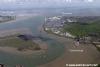
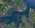
Medway 1, Entrance, Creeks and Anchorages up to Gillingham Reach
Your Comments: 8 Read or add your comments
Courtesy Flag
Flag, Red EnsignWaypoint
From the W. Nore Swatch R.Buoy: 51:28'.3 N 000:45'.55 E From the E. No.5 G.Buoy 51:28'.1 N 000:48'.5 E Position Approx.Charts
Admiralty, 1834, SC5606Rules & Regulations
A 6 knot speed limit operates west of Folly Point on Hoo Island. Monitor VHF Ch 74 and 16
Hazards
Explosive Laden Wreck in the Approach, Overfalls near Sheerness Fort on the Ebb.Tidal Data Times & Range
HW Dover +0130 at Sheerness, HW Dover +0140 Chatham. Data at Sheerness..MHWS 5.8m MHWN 4.7m, MLWN 1.5m, MLWS 0.6m (links)This site is designed for slower, roaming broadband connections, like you would get at sea, so it needs JavaScript enabled to expand the text.
Approach
Ships approaching the River Medway tend to come up the Thames Estuary using the Princes Channel..... ... read more
Berthing, Mooring & Anchoring
For the yachtsman or motorboater, entry to the Medway also leads to Queenborough. ... read more
Your Ratings & Comments
8 comments
Update May 2022
Written by Don Thomson 3 | 9th May 2022
No changes
UPDATE SPRING 2021
Written by Don Thomson 3 | 19th Mar 2021
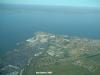
These notes were reviewed in March 2021. There are no changes to facilities in this area but do not rely on industrial features on any charts, especially chimneys. As far as I can see Kingsnorth Power station is no more and its chimneys, floodlights, tanks and buildings have been raised to the ground. The jetty is still there and possible the gantries on it. The Isle of Grain Power Station is similarly challenging but there are still some chimneys left there, we think!
Kingsnorth power station chimney
Written by Paul M | 26th May 2019
The 200m chimney of Kingsnorth Power station was demolished on the 22 March 2018.
UPDATE SPRING 2018
Written by Don Thomson | 4th Apr 2018
Much has changed here in the way of organisation but, as far as we can tell, there have been no changes to the way they want yachts to behave. The tall chimney that used to be at the Grain Power Station has been demolished. Prices have gone up across the board and we have updated the charts here.
Update Spring 2016
Written by dononshytalk | 21st Mar 2016
These notes were reviewed by Don in March 2016. There are no significant changes here but do note our members warning re the two gas holders at Gillingham.
Gillingham land mark
Written by DarkIvy | 28th Feb 2015
This entry has been moved to Medway 2
Update April 2014
Written by dononshytalk | 11th Apr 2014
These notes were reviewed in April 2014 and, apart from some additional notes on the buoyage, no changes were made
Update 2013
Written by dononshytalk | 20th Mar 2013
These notes were reviewed by Don T on the 20th March 2013. No changes

© visitMyHarbour.com | website design created by Black Culm Ltd