You are viewing the expanded version of this Harbour,
for faster browsing
use the regular version here

Keyhaven
Courtesy Flag
Flag, Red EnsignWaypoint
None GivenCharts
Admiralty 2021, 2035, SC5600Rules & Regulations
4 Knts Speed LimitHazards
Shallow Bar, Much Dries WithinTidal Data Times & Range
Double HW at Springs, Long Stand at Neaps, HW Springs (1st) -0555 Dover, HW Neaps +0010 Dover, MHWS 2.7m MHWN 2.3m MLWN 1.4m MLWS 0.7m Tide tables: (links)This site is designed for slower, roaming broadband connections, like you would get at sea, so it needs JavaScript enabled to expand the text.
General Description
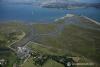
A quick glance at the photo gallery and the chart will soon show you that Keyhaven is not really a place for big boats. On the other hand we have had favourable reports from members who have anchored at the entrance.
Even if you do get in on the tide, the only place available for anchoring is in a deep pool just within the entrance. It is exposed to easterlies and doesn't really give protection from the wind, furthermore there are anchoring charges.
Smaller shoal draft craft prepared to take the ground can work their way up to the quay for an overnight stay, or may be able to get a mooring buoy.
Limited facilities ashore.
Approach
The entrance is not easy to identify, it lies about half a mile to the NNW of Hurst Point.
When approaching allowance should be made for a strong tidal cross stream, with the outgoing southward bound stream reaching 2.5 kn. Yachts drawing 1.5 m can normally enter and depart two hours either side of high water, shallower draft craft have a bigger window. There is a 4 kn speed limit within.
Pilotage details for entering Keyhaven are now given:
New PHM 2014 The gravel bank extending to the North West off the end of North Point has been dredged and a new, lit PHM has been laid. Position 50 42.880N 001 33.358W F(3)R 9s (Now included on the latest UKHO chart)
Approach from the West will be made either through the North channel or the Needles channel, and if using the former give a wide berth to The Trap just after Hurst Point. Approaching from the East is straightforward enough, providing you keep a sharp eye out for the Lymington/Yarmouth ferries.
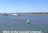
It is not wise to attempt entry in strong easterly winds, and in any case there is no real shelter within from this direction. The soundings on the Admiralty Chart are about six years old (and were only partial at that) and we are advised that North Point and the channel are not exactly where they appear to be on the chart; (hence the latest PHM!) it would be unwise to venture in here following a GPS plotted course - use the Mark I eyeball. Approach from a point about half mile east of North Point in such a way that it bears between 270° and 290° and cautiously move in. Transit markers are shown on the Keyham chart which line up on 308° and are black as marked on the chart. There are reports that these markers can be difficult to pick up. Keep your eyes peeled for the small red and green unlit buoys marking the entrance, bearing in mind the possible tidal cross set mentioned above. Try to pass between these whilst making good 308° and keep going a little further then swing gently round to port (leaving that "O9" sounding to port) and leave the new PHM to port and aim to keep the next two green buoys close to starboard.
This brings you into the area of the Anchorage, and if intending to stop here anchor close in to the sand spit, as shown on the chart. Those of you who have visited here in the past will know of a "hole" off to starboard as you head south into the Anchorage (veering off at the first green buoy); that hole has opened up to the extent that the Harbour Authority has decided to utilise it for permanent moorings so there is an extra trot of five mooring buoys there now and it is no longer available as an anchorage.
If making for the Quay follow the green buoyage and when this runs out follow the moorings. The deepest water is always near the bows of the moored boats. From North Point the channel trends southerly, westerly, then north-westerly into Long Reach. A green buoy at the end of Long Reach marks the point at which the channel dries completely at LAT, but with a suitable rise of tide craft can make it to the Quay.
Anchoring is not allowed in these channels as they are in constant use, the only place allowable has been mentioned.
Berthing, Mooring & Anchoring
Quite sizeable boats can work their way up to Keyhaven Quay and the boatyard, but unless you have prearranged business, it is probably unwise to nose up here in a larger boat. Mind you, the boat in the video being taken up by Dillon is a Centaur which is 26'
Anchorage has already been described, and the only other options are these: If you have a very small craft you could pick up a vacant mooring buoy amongst similar sized craft for a short period only. The other option again in small craft is to make your way to the Quay and tie up there. There is over 2m at the Quay at HW Springs
The Quay and the slipway are often in use by the resident boatyard during the weekdays, and the quay is also used by fishing vessels and small ferries.
The best plan would be to contact Keyhaven River Wardens (Jim and Steve) on VHF channel 37, telephone on 02380 285901 to check the availability of space on the Quay.
It should be borne in mind that you're very likely to come across children afloat in various dinghies etc., and that sometimes you may encounter swimmers near the Quay.
There are charges for anchoring or mooring which are per boat (2025):- Anchoring £12.50, Deep water Mooring £25.00, Part Drying mooring £18.80 and, on the Quay short term- £15 (Very low capacity and advised to check with River Warden first). These include VAT @20% and are collected by the River Warden, a council employee who also enforces the 4 kn speed limit, and generally oversees and supervises the moorings (he has been known to "adjust" prices for smaller boats). The moorings are all under council control.
Further Berthing Information
"....You can also get inside the spit, where you can lay quietly in the small pool on the port hand between the entrance and the fisherman's pontoon. According to local knowledge (many thanks to Chris Enstone) the entrance is navigable at HW +/- 2 with a draft of 6 feet. When anchoring, keep clear of the main channel, anchoring fore and aft makes room for more visitors. We have been caught for £8 by the local harbourmaster but he's not too diligent at chasing for his money. The shingle beach is fine for barbecues and beachcombing but sandcastles are out. A visit to Hurst castle is a must, possibly combined with a cheap lunch at the cafe inside.
Just a quick note about the entrance, keep to starboard when entering, the spit on the port hand side extends further than you may think. 2009, the harbourmaster told us that the spit has been dredged, so the entrance is fairly wide again."
This information is reproduced here by kind permission of Alan Holmes, his site below has much information about Solent harbours and anchorages, has some good photos, and is based on plenty of hands on experience...check it out
http://www.troppo.co.uk/tightwad/tightwad.htm
Ed Note Much of the detail on that site is now out of date, you'll pay at least £10 to anchor and the chart re-produced there is no longer correct.anchor
Facilities
Water is available from the boatyard or a tap by the warden's office. West Solent Boat Builder's boatyard offers repair facilities and winter storage. It's equipped with a crane and the 25 tonne slip and also has a small chandlery.
Fuel is not available here, the nearest is miles away. Provisioning can't be accomplished here either, and there is no public transport. However, there are shops and pubs in Milford on Sea which is about twenty minutes walk away and an alternative to the Gun Inn
The slipway is available at three quarters of the tidal range for trailer craft, but PWCs are banned. Full details can be had from the River Warden, who's phone number has already been given.
Keyhaven Yacht Club is by the Quay, and is welcoming to visitors from other yacht clubs. Telephone 01590 642165, link below:
Eating, Drinking & Entertainment
The Gun Inn is the only hostelry available in the area and serves food, while having a reputation for real ale and a good collection of malt whiskeys.
Links
|

Your Ratings & Comments
The anchorage marked on the chart, just inside the bounding eastern spit, provides shelter from easterly seas but not the wind; in a westerly it's a lee shore. And if you're too close to the spit as we were obliged to be, the bottom is shingle rather than mud. I suspect the flat drying area in front of the castle might be better. There are a few visitors' moorings, and a vacant resident's one might be available. Tying up on the quay is discouraged.