You are viewing the expanded version of this Harbour,
for faster browsing
use the regular version here


Langstone Harbour
Courtesy Flag
Flag, Red EnsignWaypoint
Harbour Entrance 50:47'.20N 001:01'.51WCharts
Admiralty 2045, 3418, SC5600Rules & Regulations
Speed Limit 10 KntsHazards
Extremely Strong Tidal Streams in Entrance (with possible submerging of mooring buoys.)Submerged Barrier between Portsea and the Horse Sands Fort. Dolphins mark the safe passage.
Tidal Data Times & Range
HW +0014 Dover, MHWS 4.8m, MHWN 3.9m, MLWN 1.9m, MLWS 0.8m Tide tables: (links)This site is designed for slower, roaming broadband connections, like you would get at sea, so it needs JavaScript enabled to expand the text.
General Description
Langstone Harbour is a large tidal Bay lying between Portsmouth to the West and Hayling Island to the East.
It is a "Internationally Important Wetland" , and wildlife flourishes in the extensive, somewhat desolate mudflats and navigable channels. It is approached through a narrow entrance through which the tide can ebb at a surprising rate.
The harbour has issued a comprehensive guide to the facilities which can be downloaded here
There are some deep water moorings available, as well as a marina. Anchorage is possible, but only with the Harbourmasters permission.
Approach is made between two fairly extensive shingle banks waiting to catch the unwary. Once within, harbour dues (see below) have to be paid by all users, whether you're using the Marina or not.
Although basic supplies can be obtained this is not the spot for a major stock up.
There is a waterskying area set aside during the summer months; the area covers the waters of the Langstone Channel and is marked by yellow buoys; for licences and charges check the harbour website.
Approach
Langstone is safe to enter in moderate conditions but for first timers it is probably best to avoid going in on an ebb tide, especially springs.
Onshore winds combined with Spring ebb tides can kick up rough, and the entrance shouldn't be attempted at all in southerly or south-easterly gales.
Approach is made between two shingle banks, Western Winner to the West and the far more extensive East Winner to the East. Pilotage details for the approach to Langstone are now given:
Depths in the approach range from 1.2 m at LAT upwards, so consultations with the tide tables will be required.
From the West it is necessary to pass outside of of Horse Sand Fort to avoid the antisubmarine barrier that stretches across from the shore. There is a gap through the middle of this which is well marked and shown on the chart in the Portsmouth article.
From the East keep well offshore to avoid the East Winner Bank and its associated shallows. There is an unlit Southerly Cardinal buoy "Winner" shown on our approach chart, and this needs to be left to starboard.
The next point to make for the Langstone Fairway beacon which is red-and-white and located at 50° 46'.32N 001° 01'.36W. (L.Fl.10s). Do not confuse this with the Roway Wreck Beacon, which is black/ red/ black and topped with two black balls (Fl.(2).5s).
Once at the Fairway Beacon the entrance to Langstone Harbour should be visible, with a conspicuous chimney on the Western side. A course just shy of of North, (say 350° to 355°), will take you through the entrance. Be aware that there may be a cross set in the approach. You can transit using the end of the pier (2F.R.(vert)) or the outfall (Q.R), (both on the western side) as your forward mark and the Fairway Beacon as a rear mark. Keeping on this line, you will be in deeper water. When closer to the entrance make your way straight in on the starboard side of the channel. .
There can be strong tidal flows in or out, and in extreme cases the moorings laid either side of the entrance channel can be dragged underwater and very difficult to spot. Furthermore large dredgers may be encountered who have no room to manoeuvre.
Berthing, Mooring & Anchoring
Once through the narrow entrance there are a couple of mooring opportunities for the visiting yachtsman or motorboater. Southsea Marina is just within on your port side.
This is covered shortly, with current prices. Yacht club moorings (with permission), harbour moorings when, occasionally, available, and anchorage (with permission) complete the picture here. These options are now covered:
There is a strict 10 kn speed limit within the harbour, other than in the designated waterskiing area.
Once inside anchoring is not allowed without the permission of the Harbourmaster, he can be contacted on VHF channel 12 callsign " Langstone Harbour Radio", or telephone 023 9246 3419. They lay three deep water visitor moorings for the summer; two are immediately North of the old Mulberry harbour section and one over to the East in Sinah Lake (up the first channel on the Starboard side as you run past the entrance. These moorings are clearly marked "VISITOR" and have pick up bridles. They charge(2020) £14.50 for overnight use of these and that is inclusive of harbour dues.
It is very much worth your while to contact the harbour in advance as they often have spare moorings in addition to the visitor moorings, or may be able to let you anchor. (If you anchor you will have to pay the harbour dues of £6.80)
Possible anchoring spots include the North side of Langstone channel, where you will be quite a way from facilities and liable to possible disturbance from water skiers.
On the Western side of the inner entrance Eastney Cruising Association maintain a few mooring buoys. These are private, but the association may allow visitors to use one of them if available. Try phoning them on 023 9273 4103, but note that these are only suitable for small craft under 7.6 m. A link to their website is provided below:
http://www.eastneycruisingassociation.com/
Other moorings within the harbour are privately owned, and many dry out.
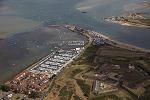
The final mooring option within Langstone harbour is Southsea Marina. This maintains 30 visitors berths and is approached via a twisting channel which is clearly marked with red and green posts. We have been advised that the entrance to this channel is not clearly marked especially on the port side. As far as we know there is a PHM (tall red pile) at the end of a small breakwater to the WNW of the Ferry pontoon and a SHM beyond that. ((Click on the the raser chart of the marina on the left below) The only advice we can offer is to pass at least a cable clear of the Ferry Pier and to maintain that distance as a radius of turn until you pick up the port hand mark on the end of the spit - and give that an offing, keeping towards the starboard side of the channel where there are moored boats. This channel has a 5 kn speed limit within it. The Marina is accessed via a tidal gate which automatically opens and closes when the depth is around 1.6 m. This effectively means that the Marina is open for about half the tidal range, and the approach channel doesn't have too much water in it at other times.
The entrance to the channel is located on your port hand side as you enter, just past the pontoon (Fl.R.20s) at the end of the spit of land on the western side. Swing hard to port once North of the above-mentioned pontoon, and watch out for cross set as you enter this channel.
The best plan would be to contact the Marina on VHF channel 80 or telephone 023 9282 2719 before attempting to enter the channel.
In the closer approach to the Marina you will find a waiting pontoon just outside the cill, and this is connected to the shore. The cill opens automatically by water pressure, and at 1.6 m it folds down flat. At this point the red traffic lights change to green and boat drawing less than 1.5 m can enter. Bear in mind the entrance is only 7 m wide, and Outward Bound vessels have the right away.
If you draw more than 1.5 m you will need to remain outside and keep an eye on the tide gauge, which indicates the depths of water available over the cill. Obviously once there is enough water you can enter.
Berthing costs (2022) in the Marina are £3.50 per metre per day, with a minimum charge of £28.00. To this has to be added the harbour dues which at £7.50 a day are quite steep, however if you are under 25ft a year's harbour dues are only £50.40 so for an extended visit it may be worth considering that. The Marina does not collect harbour dues on the behalf of Langstone Harbour; these would be collected by the harbour RIB or over the phone by card.
The facilities within the Marina include water and complimentary electricity on the pontoons, toilets, laundry and showers ashore, Four hours worth of Wifi, together with diesel, petrol, and gas. They possess a 20 tonne travel lift, plus a crane.

Marine specialists are onsite or can be organised through the Marina, or check the directory. A link to their website is provided below:
https://www.premiermarinas.com/UK-Marina-locations/Southsea-Marina
Updated March 2022
Further Berthing Information
"There are visitor's buoys on the Starboard hand on the way into the harbour which can be picked up for a visit to the pub. (Editors note - These are no longer maintained). Further into the harbour, past the remains of a wartime Mulberry Harbour, following the Langstone channel, you can anchor on the edge of the channel. This is a waterski area so it can get a bit noisy at times. When the tide goes out it leaves acres of hard sand for the kids to play on. If you can take the ground, it's also a good place for a quick scrub off.
Guide price : Free at anchor." (+Harbour Dues)
This information is reproduced here by kind permission of Alan Holmes, his site below has much information about Solent harbours and anchorages, has some good photos, and is based on plenty of hands on experience...check it out
http://www.troppo.co.uk/tightwad/tightwad.htm
Facilities
If at anchor there is not much in the way facilities. Diesel and water are available from Hayling Pontoon, on the eastern side near the harbour master's office. This has plenty of water but it's very busy, and boats must not be left unattended without HM's permission. Failure to observe this can result in your boat being towed away, with you receiving a hefty bill.
On this eastern side will be found a pub, a cafe, and a small general store. The ferry crosses the harbour entrance to Eastney all year, and from there you can get to Southsea and Portsmouth either by bus or a very long walk.
Trailer Sailers will find a slipway on this side adjacent to the Ferry Boat Inn, this is usable all states of the tide and there are charges. There are also charges for car parking nearby. PWC's are able to use this facility, but all users should be acutely aware of the strength of the ebb tide in this area when attempting to launch and recover.
Of the Western side Eastney Cruising Association welcomes visiting yachtsman, and their clubhouse contains showers, bar and restaurant. Their contact details have already been given.
Also on this side will be found a small convenience store with a cashpoint that is open seven days a week. The main shopping area is in Southsea which is a long hike away, and here you will find a supermarkets and a bank. A bus runs from the Marina to Southsea Central, and one of the supermarkets there (maybe Sommerfield's) will probably be able to deliver your large orders direct to the Marina.
All in all there is enough in the immediate area for day-to-day provisioning, fuelling and watering the boat and a couple of choices for eating and drinking which will be covered next.
Surveyors:
|

History
Langstone is a village near Havant, Hampshire in the south east of England, between Portsmouth and Chichester.
It has good railway connections to London, Southampton, Portsmouth and Brighton, from the nearby Havant railway station. There are many large gated detached houses on the main road, "Langstone Road" and on the roads surrounding this. It has a sailing club, several architecturally unusual buildings, and several historically significant buildings, including a converted (water) millhouse and a converted 18th century windmill, the latter of which is a local landmark.
Geography
The village surrounds "Langstone road" which leads to Hayling Island. There is a technology park on Langstone Road and this is due to the connections of the road. It lies just off the A27 that provides quick links to Portsmouth, Southampton and Brighton. The A3(M) to London is also nearby and the distance to the M25 is about 45 miles.
It is connected by Langstone Bridge, a single-carriageway road and footbridge, to Hayling Island to the South; as this road (the A3023) is the only road connection from the island to the mainland, rush-hour traffic is usually a major problem, with queues a kilometer long not uncommon. A low-tide footpath to the island used to exist, however it is no longer usable as the waters were deepened to allow the passage of larger vessels. Langstone Harbour lies to the west of the bridge; Chichester Harbour to the east.
The village High Street is designated as a Conservation Area (denoted by a blue plaque at the sea-end of the High Street), while the coastal path leading eastwards from the village is both part of Hampshire County Council's Solent Way and the same Councils' Wayfarers Walk.
Thorney Island and Portsea Island are also both clearly visible from the village coast.
Flooding can be a problem in the village, on occasion with water right up to the main Langstone Road, and many buildings on Langstone High Street have slots for wooden barriers on their door frames, and stack up sandbags.
Houses in the terrace on Langstone High Street date back to the 1700s and a number are thatched. The other significant buildings, commonly featured in local postcards, is Langstone Towers, characterised by a large lightning conductor.
History
The village used to have rail links with Hayling Island and Havant in the form of the Hayling Billy railway, however the lines have since been torn up and the route replaced with a cycle and bridlepath. The remains of the Hayling Billy rail bridge over to Hayling Island can still be seen.
The text on this HISTORY page is covered by the following licence
http://en.wikipedia.org/wiki/Wikipedia:Text_of_the_GNU_Free_Documentation_License
Eating, Drinking & Entertainment
Virtually on-site in the Marina is the Bombay Bay Indian restaurant.
On the eastern side there is the Ferry Boat Inn, which does good bar meals.
If you want to make the journey to Southsea there are any number of pubs, bars, and restaurants to choose from. Links are provided below that cover the Southsea area:
Pubs.
http://www.beerintheevening.com/pubs/results.shtml/el/Southsea%3BHampshire/
Eating Out.
The 10 Best Restaurants Near Southsea Beach, Portsmouth - Tripadvisor
Links
|

Your Ratings & Comments
Paul Reading
The other issue is the fishing boats do a very interesting 10 knots and make a big wash with isn't very fun to be hit by side on. The first mooring in the row which is the one closest to the slipway is a short stay only mooring, all the others are 24 hour moorings.
hope this helps.
View all 11 feedback items