You are viewing the expanded version of this Harbour,
for faster browsing
use the regular version here

Ventnor Fair Weather Haven
Courtesy Flag
Flag, Red EnsignWaypoint
None GivenCharts
Admiralty 2045, SC5600Rules & Regulations
No Discharge of Marine Toilets in Drying HarbourHazards
Lobster Pots in Approaches, Drying HarbourTidal Data Times & Range
HW Approx Same as Dover, MHWS 3.9m, MHWN 3.2m, MLWN 1.7m, MLWS 1.0m Tide tabes: (links)This site is designed for slower, roaming broadband connections, like you would get at sea, so it needs JavaScript enabled to expand the text.
General Description
Ventnor is a small seaside town lying a few miles eastwards of St Catherine's Point on the Isle of Wight.
NOTE: This "harbour" cannot be considered as anything but an emergency stop
The town achieved popularity in the Victorian era as it very sheltered from cold harsh northerly winds. St Boniface Downs the highest point on the Island shields it completely, consequently it developed its own very mild microclimate. The tiny drying harbour is only really suitable for a summer stop in settled conditions for boats that can take the ground.
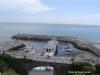
Nowadays Ventnor is a popular little resort with a nice stretch of beach, and a very steep climb up to the main town.
Ventnor Fairweather Haven is a relatively new development that accompanied the building of the pumping station on the seafront. The main reason for it's existence is to house the small fishing industry that used to operate directly off the beach.
Smallish fast fibreglass outboard powered workboats would return with their catch and virtually drive the vessels up the beach, and large winches would finish the job off hauling them right up.
This was obviously unsatisfactory during the winter months, when sometimes weeks would go by with the boats unable to launch due to the roughness of the sea. It was decided to kill two birds with one stone, and make this Liliput harbour available for leisure sailors also. The idea was to attract seaborne visitors.
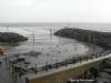
Although it is the only harbour on the back of the Wight, in no way can it be considered a safe haven. Firstly it dries out at low water, secondly there are no convenient walls within on which to lean a keelboat. Finally it's entrance is directly open to the SE, and gales from this direction would probably make things dangerous inside the harbour.
Skippers who have visited here before must note that they no longer provide buoyage for visitors outside the harbour. Shallow draft boats that can take the ground should be able to find somewhere to dry out overnight; otherwise it's only good for a quick visit for an hour or so either side of HW.
As far as we can gather there are now three pontoons here in addition to the fisheries building and its associated pontoon underneath. The Council operate the most Easterly one, the others are private. The Council are reluctant to "advertise" this little harbour because it is very exposed and there is very little room inside.
Boat facilities are thin on the ground, and any provisioning will involve a very steep climb to the town. Nevertheless there are plenty of holidaymaker type attractions on the seafront.
Approach
The best approach to Ventnor is made from well offshore, approaching the Haven when it bears North.
Aim for a point slightly west of the Haven itself, with the road cascading down to the beach from the town making a useful landmark.
An approach to the harbour entrance can be made from anywhere in the Southerly quadrant (SE to SW) towards the outer pierhead, keeping a good lookout for lobster pots. The peirheads are marked by standard red and green lit marks but a night time approach is not recommended.
Boats able to sit upright and take the ground will find approximately 1.5 m of water inside the harbour approximately 1 hour either side of HW.
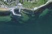
There is no proper chart available for this harbour yet, so the sketch plan and the Google link below will have to do.
A link is provided to the harbour's website below:
Berthing, Mooring & Anchoring
Visiting yachts or motorboats tie up where directed within the harbour but basically there is not a "Welcome" mat laid out here
There is a floating reception pontoon, but any stay in the harbour itself may involve dinghy work. In the absence of large scale charts for the area an idea of what the harbour looks like can be seen in this Google maps Link
Charges (2018) if you can get space on the pontoon overnight will cost £2.40 per metre
Anchoring is not really recommended in this area. Fairweather anchorages can be had in Sandown Bay, and also Whitecliff Bay which is covered in a separate article.
Facilities
Not much really, no electricity or drinking water. There is however a supply of freshwater tapped from the waterfall nearby, and this can be used for boat washing etc.
The showers and toilets promised for 2008 have materialised and the key is available from the HM or at Cheetah Marine in the large blue building on the foreshore.
Provisions can be obtained from the main town which involves struggling up the very steep winding road outside the harbour. There is a Co-Op and Hurst's hardware shop amongst the other local shops (at least it's downhill when laden with shopping !).
No fuel or gas available around the harbour.
There is a free public slipway in the corner of the harbour for launching and recovery which looks like it could be used a couple of hours either side of high water by shallow draft craft.
History
Ventnor is a seaside resort and civil parish established in the Victorian era on the south coast of the Isle of Wight, off the southern coast of England. It lies underneath St Boniface Down (which, at 787 feet, is the highest point on the Isle of Wight), and is built on steep slopes and cliffs leading down to the sea. The higher part is referred to as Upper Ventnor (although officially it is Lowtherville); the lower part, where most of the amenities are located, being known as Ventnor. Ventnor can sometimes include the villages of St. Lawrence and on the other side of town the village of Bonchurch.
The sheltered location on the cliff of the island's south coast means the area experiences a microclimate with more sunny days than much of the British Isles, and fewer frosts. This has allowed many species of subtropical plant to be successfully planted and maintained. Ventnor Botanic Garden is particularly notable.
Geology
The geomorphology of the area in many ways defines the town. It varies greatly, with a significant area built on clay which suffers from serious landslip. The ground at Ventnor is notoriously unstable, and many buildings and amenities have been lost to subsidence or cliff-falls. There is a local expression: "We live near the sea and are getting nearer every day." This has led to considerable concern and study of the situation. This is the subject of displays at the Isle of Wight Coastal Visitors Centre in Ventnor. One nearby Site of Special Scientific Interest is known as "The Landslip".
At the top of the town is a geological fault known as the Graben, which marks the top of the series of landslips on which Ventnor is built. This fault moves regularly, and has been the cause of the destruction of numerous buildings over the years, serious cracking to the road which crosses it, and repeated disruption to the town's utilities, which are supplied by pipes and cables which have to pass over the fault.
Three miles (five kilometres) off the coast of Ventnor, the seabed forms a long parallel ridge and rises to within fifteen metres of the surface. The action of the sea rushing up the channel and being forced between the Island and this ridge, has carved out a narrow channel of extraordinary depth known as St. Catherine's Deep.
Ventnor Beach
[edit] History
The town grew from a small fishing hamlet in the nineteenth century between the two villages of Bonchurch to the east (whose parish Ventnor is situated in) and St Lawrence to the West. Charles Dickens lived nearby for some time. However, it was with the coming of the Isle of Wight Railway in 1866 that the town became both a tourist and a health resort. The fresh English Channel air and warm climate were considered to be very beneficial to the sufferers of tuberculosis. Several sanatoriums were established in Ventnor for those suffering from the disease. The Isle of Wight Railway at one time ran a non-stop train from Ryde to Ventnor which was named 'The Invalid Express' specifically to rush consumptive patients to their treatment at Ventnor. One train famously completed the journey in a little over twenty minutes. There is no record of the effect this dash had on the already ill passengers. The town reached its zenith in the inter-war period of the nineteen-thirties with regular steam packets operating between Southsea and the town's pier. The sandy beach was ideal for bathing, and is still popular today, although it is much smaller than other comparable tourist beaches at nearby Sandown and Shanklin.
Transport
History of Railway
Ventnor railway station was the terminus of the Island Line railway from Ryde through Sandown and Shanklin, and it brought many visitors to the town. Ventnor West railway station was the terminus of the line from Cowes through Newport. Both stations suffered from being well away from the town centre, necessitating a road journey for travellers to get to their destination. Ventnor West station was closed early in the 1950s, long before the closures ordered by Dr Beeching. Ventnor station was closed in 1966, ironically just before the surviving Ryde - Shanklin line was electrified. Thereafter the town suffered a period of economic decline, from which it has not fully recovered.
However, since 2004, a connecting Rail Link bus (Service 16), run by Wightbus, has run from St Lawrence and Ventnor to Shanklin, making through rail journeys to and from Ventnor easier.
Current bus services
As mentioned above, Rail Link route 16 connects Ventnor to St Lawrence and Shanklin railway station; Southern Vectis run buses on route 3 and route 6 from Ventnor to destinations including Newport, Ryde, Sandown, Shanklin.Additionally, Wightbus run the local number 31 route, which connects Ventnor to Bonchurch Village and provides additional journeys to Wroxall.
Ventnor Botanic Garden
Ventnor Botanic Garden is on the site of an old hospital and has a variety of tropical plants due to Ventnor's subtropical microclimate. A rainfall of 31 inches (790mm) per annum and a climate more akin to the Mediterranean seaboard enable a wide variety of plants considered too tender for much of mainland Britain to be grown. The garden includes areas of plants from different parts of the world, particularly Australia and New Zealand, but also including Japan and gardens with plants of a Mediterranean origin. There is a temperate house, and a visitor centre which was renovated in 2001.
Other places of interest
Smaller Parks and Gardens: The town has a small park on the west side of town with a bandstand, aviary and stream. There is a garden crossed with a waterfall, built in the Victorian era of the town, around which winds the main path between the beach and the town. The waterfall is known as The Cascade. There is also a paddling-pool on the sea front esplanade. In the middle, rising out of the water is a model of the Isle of Wight which children can play on. The hills and inlets are physically modelled and the towns and roads (in red) are painted on. In the past, the Island's remaining railway line has also been shown (in black).
VENTNOR Sign: There is a sign on the cliffs at La Falaise to the west of the beach which spells out the word VENTNOR in white concrete blocks, about four metres high and intended to provide a landmark visible from the sea. This replaced the chalk letters damaged in 1992. Since about the start of the current millennium, there have also been smaller metal capital letters spelling out the town's name. These are fixed to the seaward side of the Southern Water pumping station, itself sympathetically disguised as a bandstand and observation platform, next to the harbour.
Antique and bric-a-brac stores: There are many of these in the main town shopping area, and these provide a tourist attraction in their own right.
Ventnor Brewery: A brewery has been in Ventnor on the same location since the 1840s. Water from the local spring, which is called "St Boniface's Well" is used to make the beer. The town was home to Burts Brewery, but it closed in the 1980s. After this, the site was empty for several years. The brewery was reopened as a microbrewery in 1996, called the "Ventnor Brewery" The Ventnor Brewery produces a number of cask ales, including the quite unusual Oyster Stout.
RAF Ventnor High above the town exists the former site of RAF Ventnor, once an RAF radar monitoring station. Now used mainly for civilian communications antennae, the site provides views over the English Channel. However the site also contains an extensive bunker complex designed to be part of an early warning network and later converted for use as a shelter in case of a nuclear strike during the Cold War. The bunker, which was a variant on the P1 ROTOR design, has now been sealed and is generally thought to be inaccessible.
Coastal Centre: On the Eastern cliff, the Isle of Wight Coastal Visitor's Centre provides access to information and resources on the Isle of Wight coastline. Ventnor is on the Isle of Wight Coastal Path.
Wall Lizard
The largest British colony of Wall lizards live in walls around the town, and a wall specially designed as a habitat for them was recently built at the Botanic Garden.
Events
Crab Fayre: Every year the town celebrates the town fair, based around the local crab harvest. It's now held at Ventnor County Middle School in Upper Ventnor.
Carnival: Traditional English town carnival held in the middle of August each year. Carnival Floats, Marching Bands and Drinking.
Isle of Wight International Jazz Festival: The 3-day festival has been held every year since 2005 during what is normally the Easter school holidays, and attracts top names from the genre. Headline acts from previous years include Maceo Parker, Humphrey Lyttleton and Cleo Laine. Entry to the main concerts is by pre-bought or (rarely) on-the-door sold tickets, but other events are free, and take place in venues varying from hotels and cafés to churches and sports clubs. Various smaller Jazz gigs are held around the town throughout the year.
The text on this HISTORY page is covered by the following licence
http://en.wikipedia.org/wiki/Wikipedia:Text_of_the_GNU_Free_Documentation_License
Eating, Drinking & Entertainment
Being right on the seafront you're probably in the best spot for choosing somewhere to eat or drink. There are various seafront cafes some of which serve terrific breakfasts.
The Spyglass Inn at the western end of the beach is a very popular spot, and used to advertise regularly on the local radio station. It is full of nautical bits and pieces and does good meals.
There are other eating and drinking options on the seafront also.
The exhausting steep hike to the main town probably makes it not worthwhile, and to be quite honest there's not really too much there. I do seem to remember a Chinese takeaway however...
For those of you up for a bit of a walk, heading West past the Spyglass Inn and following the coastal footpath will presently bring you to Steephill Cove. This is perhaps one of the Isle of Wight's most hidden treasures, no doubt due to the fact that it is completely off the beaten track.
A pretty little bay, with decent beach and what was once a tiny fishing community. Boats pulled up on the foreshore, a small cluster of cottages and a cafe with a terrace complete the picture here.
The green fingered may well fancy having a look over Ventnor Botanic Gardens which lie to the West of the town but unfortunately will involve that steep climb again.
The main road out of Ventnor heading towards St Catherine's has always been a bit precarious, and a few years back a small portion of it collapsed and slipped away. This portion has now been replaced, and some would consider that this whole road is one of the prettiest to drive on the Island, particularly on a powerful motorbike.
Most patrons of Ventnor Fairweather Haven will arrive with stores on board, fuel in the tanks and enough cooking gas. An pleasant evening spent out on the seafront will probably be the extent of their acquaintance with Ventnor.
In conclusion the Haven could make a useful overnight stop in settled weather for small craft, and will hopefully prove a useful attraction for the town.
Links
|