

Marina Information (use the  icons to find out more)


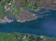
Canvey Area (inc Southend, Leigh on Sea, Benfleet, and Holehaven)
Your Comments: 10 Read or add your comments
Courtesy Flag
Flag, Red EnsignWaypoint
Off end of Southend Pier 51:30'.8 N 000:43'.4 E Hole Haven Entrance 51:30'.5 N 000.33'.235 ECharts
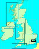
Admiralty, 1185, SC5606Rules & Regulations
8 knt Speed Limit in CreeksHazards
Shipping in the Main Channel, Creeks all Dry Out.Tidal Data Times & Range
Dover +0125 At Southend MHWS 5.8m, MHWN 4.7m, MLWN 1.4m, MLWS 0.5m (links)This site is designed for slower, roaming broadband connections, like you would get at sea, so it needs JavaScript enabled to expand the text.
General Description
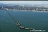
The area described stretches from Southend Pier to Hole Haven Creek, and is home to a couple of thousand shoal draft yachts and other shallow craft. ... read more
Approach
Yachts and motorboats making for Leigh on Sea, Canvey or Benfleet will have to locate Ray Gut.... ... read more
Berthing, Mooring & Anchoring
Ray Gut can provide a useful Anchorage for even deeper draft craft on a temporary basis. ... read more
Your Ratings & Comments
10 comments
Update May 2022
Written by Don Thomson 3 | 11th May 2022
We have a new survey from the BYC - it is full of good advice.
1 of 1 people found this helpful
UPDATE SPRING 2021
Written by Don Thomson 3 | 23rd Mar 2021
I reviewed these notes in March 2021. The BYC have not yet surveyed their approach channel but I hope to get a link to their survey later in the year. Of the Links to the Dauntless yard given by our member below the one to the chandlery works, the one to the boatyard does not. and I have updated the info in the text. Do not forget that the London Gateway on the North shore a mile up river from Holehaven is now fully operational and give it a wide berth.
Dauntless
Written by vargata | 29th Jun 2020
Dauntless boatyard link is broken
They have new website: https://dauntlessboatyard.com/
and the chandlery: http://www.dauntlessyachtcentre.co.uk/
both sites have their phone numbers in contact details
cheers
They have new website: https://dauntlessboatyard.com/
and the chandlery: http://www.dauntlessyachtcentre.co.uk/
both sites have their phone numbers in contact details
cheers
Update Spring 2019
Written by Don Thomson 3 | 2nd Apr 2019
There are new charts for Benfleet. The main change is to the Leigh Buoy (which was a starboard hand buoy which those in the know passed to port!!) - this is now in a position on the starboard hand of the channel and should be left as normal to starboard.
UPDATE SPRING 2018
Written by Don Thomson | 4th Apr 2018
We are enquiring as to when the next survey of Benfleet Creek will be available; until then note that the survey we link to was in November 2016. We have loaded a new chart.
Navigation
Written by Moonfish | 7th Sep 2016
As from 1100 today(07/09/2016) the chimney at Grain on the Hoo peninsula. Has been demolished. This long standing navigational aid has gone
2 of 2 people found this helpful
Update Spring 2016
Written by dononshytalk | 23rd Mar 2016
These notes were reviewed by Don in March 2016. A link has been provided to the Benfleet Yacht Club's 2015 survey of Benfleet Creek but you should be very aware that the depths around here are very much a moving feast.
Update April 2014
Written by dononshytalk | 16th Apr 2014
These notes were reviewed April 2014. The chart in our gallery is the latest and it appears that the buoyage at the entrance to the Ray Gut has changed and there are new soundings all the way up. Whatever else, it is clear that the present "Leigh" SHM needs to be left to PORT when entering this channel and this information has been confirmed by a local tug skipper
sea fishing along the coast of essex
Written by joe | 22nd Jul 2013
im 38 and been sea fishing for over ten years, i can honestly say i have had no results along southend coast from beach, i think this trolling for cod and flat fish like dabs should be banned until we start getting results, i find it to be disappointing living near the Thames and having to travel to Clayton to where the best coast is for fishing. best result i ever had is from old Leigh on sea, i caught bass which was very good for size but still little under size to eat, i caught flounders from the beach in Leigh which were good size and nice to eat, boat angling is very good at times out by the towers, ive had 10 dog fish in under hour, which was only 1 off, after me fishing these waters in spring are good, but only on Boat. thank you people i keep you up dated
Update 2013
Written by dononshytalk | 25th Mar 2013
Thsea notes were reviewed by Don T on the 25th March 2013. The only real change is the ownership and telephone number of the Marina at Smallgains Creek and they are still a very cheap option. If you explore the Benfleet YC website you'll notice a "new" navigational warning about buoyage in the Gore Channel on the North Kent Coast and another reference protective berms over the cables out to the Kentish Flats Wind Farm - both those changes have already been edited on to the Admiralty charts and are available to visitmyharbour members.

© visitMyHarbour.com | website design created by Black Culm Ltd