You are viewing the expanded version of this Harbour,
for faster browsing
use the regular version here

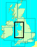
Caernarfon Harbour (and Caernarfon Bar)
Courtesy Flag
Flag, Red EnsignWaypoint
None GivenCharts
Admiralty 1464, 1970Rules & Regulations
5 Knts Speed LimitHazards
Caernarfon Bar...dangerous in onshore conditions, see textTidal Data Times & Range
HW = Dover -0130 MHWS 5.2m, MHWN 4.0m, MLWN 1.9m, MLWS 0.6m (links)This site is designed for slower, roaming broadband connections, like you would get at sea, so it needs JavaScript enabled to expand the text.
General Description
The reputation of the Caernarfon Bar and the Swellies is often enough....
..... to deter boat owners from visiting the Menai Strait. However, providing these waters are treated with the respect they deserve and you do your homework before visiting then the rewards are well worth the effort.
This is an area of outstanding beauty, and apart from Caernarfon (a very useful stopover), there are other mooring opportunities within the Menai Strait, both above and below the Swellies.
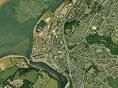
Caernarfon lies just inside the southerly entrance to the Menai Strait. The Strait separates Anglesey from mainland Wales and is highly tidal. This article covers Caernarfon Bar, that must be crossed to get to the town of Caernarfon and also to enter the Menai Strait from the south.
Navigating all the Menai Strait itself must be the subject of another article, the tides are complicated and there is a notorious area known as The Swellies to be negotiated. More information about the tidal streams Menai Strait will be found in both the history section and More Information Section below. There is also a website which gives step by step instructions on how to pass the Swellies:
http://www.traethbychanharbour.co.uk/navigate-the-swellies.html
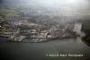
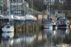
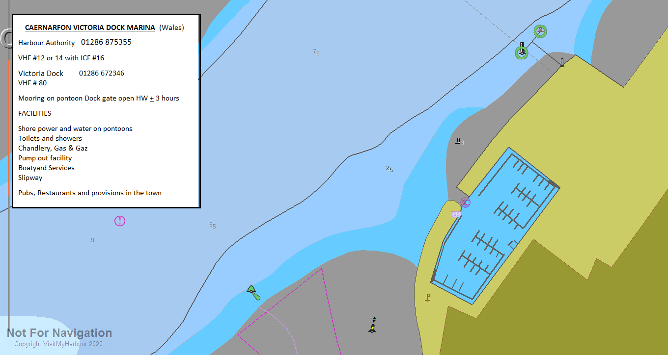
Caernarfon could be a useful stopover, with provisioning easily accomplished. Berths are available in Victoria Dock Marina, where vessels may lie afloat. This is entered via a tidal cill with flap gate. Other drying berths may be possible in the Afon Seiont, leaning against the wall.
Approach
Unless entering the Menai Strait from the North and passing the Swellies,.....
..... the visiting yachtsman or motorboater will be approaching from the West and will have to negotiate Caernarfon Bar, which must be crossed to get to the town of Caernarfon and also to enter the Menai Strait from the south.
Pilotage Directions: A quick glance at the chart will show that there are sand banks extending roughly 3 miles from the coast, with a shallow channel marked by buoyage leading to the very deep and narrow entrance at Abermenai. At this bottleneck the tides can reach 5 kn, so entry should be planned at slack water or with the tide under you. The authorities here say that the bar should only be attempted 3 hours either side of HW
Caernarfon harbour authority are responsible the buoyage over the bar, and they produce a guide giving the latitudes and longitudes of each of the buoys, together with a chartlet in PDF form for you to download. They produced a new chart on the 24th of April 2022 and it can be found at
http://www.caernarfonharbour.org.uk/caernarfon-bar/ Opens in a new tab
The observant of you will immediately note that the buoyage on the chart supplied by the harbour bears no relationship to the 2022 Admiralty Chart (which we have uploaded to our chart gallery)
These sandbanks are constantly shifting, and the buoyage is moved around to suit. Bad seas can build up on the bar in any kind of strong onshore conditions. The situation is made worse when an outflowing tide meets an oncoming wind. Even moderate onshore winds combined with an ebbing tide can make the entrance impassable. Heavy ground swell in the Irish sea can cause severe problems at the bar even in moderate conditions too.
A first-time entry is only recommended in offshore or fair weather conditions, with little or no swell running. You will also need a good half mile visibility so that you can eyeball the next buoy as you tiptoe in.
If if any doubt the best plan would be to contact the harbour master at Caernarfon for the latest information and advice on Crossing the bar, telephone him on 01286 875355
An attempt at crossing the bar should only be made at a maximum of three hours either side of high water.
A link is given to their home page, which also contains much useful information for a proposed visit:
http://www.caernarfonharbour.org.uk/
Once past Abermenai Point, following the deepwater north eastwards will bring you to the easily recognisable town of Caenarfon, with its Castle and Walls.NB The No C10 red can buoy and the No C7 SHM have moved significantly NW to the other side of that sandbank. If you are to continue up the Menai Strait it's important to note that the direction of the buoyage changes at Caenarfon. This point is marked with a southerly Cardinal "Change" buoy. Up till now you have been proceeding with red can buoys on your port side, and green conical buoys being left to starboard. Lateral buoyage always follows the direction of the flooding tide.
In the Menai Strait the tide floods in from both ends, thus the lateral buoyage follows the flood, and the area mentioned above is for historical reasons the point chosen in which the buoyage changes direction. This is actually a very simplified version of events, and for those interested in navigating the Menai Strait, Richard Jones, the Caernarfon harbourmaster has provided us with a thoroughly accurate rundown of how the tides really do behave in the area. You can find his description in the more information section on this page.
Once off the town, the Marina in Victoria Dock will be visible, and can be entered a couple of hours either side of high water. Depths inside the Marina are maintained by a flap gate so no locking in is required.
If you need to wait for a rise of tide there is a pier (Landerne Pier) just up river of the Marina where there may be room to tie up. Otherwise you can anchor off the town temporarily. Tides can run up to 3.5 kn here, and holding has been reported as indifferent. The Caernarfon harbour trust also provides two courtesy mooring buoys situated just to the south west of the C9 starboard hand buoy. These buoys are Orange Hippo Buoys, have no pick-up strops and are only rated at 3 tons.
Likewise if planning to enter the Afon Seiont and head for a drying berth alongside the quay you may need to wait for the footbridge to be opened.
In either case once you're ready to make your move be aware of the strong cross tides in the approaches.
Berthing, Mooring & Anchoring
Moorings for visiting boats are either in the small Victoria Dock Marina,....
..... Harbour Authority mooring buoys or within the Afon Seiont. It may sometimes be possible to tie up overnight on Landerne Pier for onward passage through the Strait (We are advised that you would pay the same rate as if you were in the Victoria dock)
The harbour authorities here work on VHF channel 12 or 14, with initial contact being made on channel 16. You will need to get in touch with them if you want to enter the Afon Seiont and obtain a drying berth on the north bank of the River (see photo gallery). Arrangements and prices are now covered.
A swinging footbridge blocks the way into the River. If the bridge doesn't open for you give the sound signal B (- ...). The swing Bridge is actually manned between 7 AM and 11 PM, and outside these hours the bridge is kept open so vessels may pass.
The channel into the River and the town moorings commences in region of an easterly Cardinal buoy and follows the town side closely. It is marked on your starboard side by green posts with conical top marks.
The Swing Bridge comes immediately after the floating restaurant, and once through it, quayside moorings are on your port side. Berth as directed by harbour staff.
 A link has already been given to the harbour authorities' website.
They also may have mooring buoys available where you will remain afloat.
The Marina too is under the control of the harbour authorities, but should you be wishing to enter you will need to contact them on VHF channel 80. Listening watch is maintained while the dock is open (up to 3 hours either side of high water maximum). Dock Telephone/Fax Number... 01286 672346.
Gate opening times
Be very aware of the cross set as you make your approach to the dock gates, which are controlled by traffic lights.
Staff operating hours here are 7 AM to 11 PM during the summer, but only during daylight hours in the winter.
The Marina is probably more convenient for the town, with the big advantage of remaining afloat at all times. It is small as marinas go, and if full you may need to enter the Afon Seiont and get a drying berth alongside the quay.
Prices (2022) in the Marina workout at £2.95 per metre per day, with electricity available at £4.03 a day.
Short stays of less than 30 minutes are not charged, while longer short stays providing they happen within the "gates open" period are charged at £11.96
Check the harbour authorities' website for any further details, links already given.
Facilities
If berthing the Marina you will have access to water and electricity on the pontoons. Toilets and showers are available ashore (and, we are informed, these are new and are a vast improvement on the previous arrangements). Access is by coded lock and the showers are included with the mooring fee. These facilities are unisex so have a care.
They hope to have a diesel fuelling dock later in 2016.
Holding tanks can be pumped. There is a slipway and liftings can be arranged by crane or hoist up to 12 tonnes. Menai Marine based at Victoria Dock handle boatyard services, including Farrow System antifouling removal.
There are Chandlers on the quayside and both Calor and camping gas can be found.
All the usual town facilities will be right on hand with supermarkets (including a Morrisons and Kwik save) and banks plus a fair selection of shops.
For crew changes the nearest main line station is Bangor, on the North Wales Coast Line from Chester to Holyhead, approximately ten miles from Caernarfon. Bangor is served by trains from Chester, Crewe, Manchester, London Euston, Cardiff, and Holyhead (for sea connections to Eire), operated variously by Arriva Trains Wales and Virgin Trains. Frequent buses connect Bangor station with Caernarfon.
Caernarfon Station actually in the town is the northern terminus of the narrow gauge Welsh Highland Railway. It was opened on 11 October 1997 when the line was constructed from Dinas, and may be worth a spin to view the magnificent scenery.
Trailer Sailers can use the slipway at Victoria Docks which is under the control of the harbour authorities. It has access at about half the tidal range and PWC's are tolerated but monitored. Speed limits of 5 kn are enforced in " populated" areas. Best to telephone in advance 01268 672118.
Tractor launching at all states of the tide is available at Ronnies (fairly close to Caernarfon). The place is open seven days a week from 8:30 AM to 7 PM, with a 7 AM start at the weekends during the season. Facilities are available and it is popular with fisherman. Phone Chris Seddon on 07917 859234 to get directions and prices.
More Info
The first of the flood tide enters at the Southern end and runs up the Strait in a Northeasterly direction. At the same time the ebb tide is still running from the central portion of the Strait in a Northeasterly direction and out past Puffin Island at the Northern end (LW at the Northern end of the Strait is almost 1 hour later than LW at the Southern end).
For a time the tidal stream is then running all the way through the Strait in a Northeasterly direction (flooding inwards at the Southern end and ebbing out from the Northern end). By about 6 hours before HW Liverpool the flood tide also starts to enter the Strait at Puffin Island. This is the initial meeting point between the two flood tides.
The range of the tide is about 40% greater at the Northern end of the Strait compared to the Southern end and therefore this meeting point between the two flood tides is gradually forced back in a Southwesterly direction as the level in Liverpool Bay is rising faster than the level in Caernarfon Bay.
By 2 hours before HW Liverpool the meeting point between the flood tides has been forced all the way back to the Swellies. At this time the level starts to fall in Caernarfon Bay and so the ebb tide starts to run in a Southwesterly direction at the Southern end of the Strait, whilst the flood tide continues to enter at the Northern end of the Strait (HW in the Northern end is about 1 hour later than HW at the Southern end). So for a time the tidal stream is now running all the way through the Strait in a Southwesterly direction.
By about 1 hour before HW Liverpool the tidal stream also starts to ebb outwards at Puffin Island and so now the tidal stream is splitting at this point. This splitting point of the two ebb tides gradually moves down the Strait in a Southwesterly direction, passing the Swellies at about 4 hours after HW Liverpool. The splitting point continues to move down the Strait to a point just Southwest of Caernarfon by 5 1/2 hours after HW Liverpool, by which time the flood has once again entered the Southern end of the Strait and the whole process is repeated ad infinitum!
Courtesy of Richard Jones, a previous Harbour Master at Caernarfon
Detailed instructions of the navigation of the Swellies can be found HERE
History
Menai Strait
The Menai Strait (Welsh: Afon Menai, the "River Menai") is a narrow stretch of shallow tidal water about 14 miles (23 km) long, which separates the island of Anglesey from the mainland of Wales.
The strait is bridged in two places - the main A5 road is carried over the strait by Thomas Telford's elegant iron suspension bridge, the first of its kind, opened in January 1826, and adjacent to this is Robert Stephenson's 1850 Britannia Tubular Bridge. Originally this carried rail traffic in two wrought-iron rectangular box spans, but after a disastrous fire in 1970, which left only the limestone pillars remaining, it was rebuilt as a steel box girder bridge. Between the two bridge crossings there is a small island in the middle of the strait, Ynys Gored Goch on which is built a house and outbuildings and around which are the significant remains of mediaeval fish traps - now no longer used.
Menai Strait west of Britannia Bridge showing the memorial to Admiral Lord Nelson
In places the strait is nearly two miles across but it narrows to little more than 200 metres where it passes underneath the two bridges. The differential tides at the two ends of the strait cause very strong currents to flow in both directions through the strait at different times, creating dangerous conditions. One of the most dangerous areas of the strait is known as the Swellies (or Swillies – Welsh Pwll Ceris) between the two bridges. Here rocks near the surface cause over-falls and local whirlpools, which can be of considerable danger in themselves and cause small boats to founder on the rocks. This was the site of the loss of the school ship HMS Conway in 1953. Entering the strait at the Caernarfon end is also hazardous because of the frequently shifting sand banks that make up Caernarfon bar. On the Anglesey side at this point is Fort Belan, an 18th-century defensive fort built in the times of the American War of Independence.
Tidal effects
The tidal effects observed along the banks of the strait can also be confusing. A rising tide approaches from the south-west causes the water in the strait to flow north-eastwards as the level rises. The tide also flows around Anglesey until, after a few hours, it starts to flow into the strait in a south-westerly direction from Beaumaris. By the time this happens the tidal flow from the Caernarfon end is weakening and the tide continues to rise in height but the direction of tidal flow is reversed. A similar sequence is seen in reverse on a falling tide. This means that slack water between the bridges tends to occur approximately one hour before high tide or low tide.
Ecology
Because the strait has such unusual tidal conditions, coupled with very low wave heights because of its sheltered position, it presents a unique and diverse benthic ecology. The existence of this unique ecology was a major factor in the establishment of the internationally renowned School of Ocean Sciences at Menai Bridge, part of the University of Wales, Bangor as well as its status as a proposed Marine Nature Reserve.The same unique ecology and geo-morpholgy has let to a number of designations of SSSIs along the strait including Glannau Porthaethwy?, the Ivy - Oak - Ash woodland on the southern shore (Coedydd Afon Menai) and Lavan sands {Traeth Laven}.
The depth of the channel reaches 15m in places, and the current can exceed 7 knots. It's very rich in sponges.
Much of the land on Anglesey at the eastern end of the strait is designated as an area of outstanding natural beauty (AONB).
Caernarfon
Caernarfon (the original Welsh spelling is now almost always used in preference to the anglicised forms, "Caernarvon" or "Carnarvon") is a royal town in Gwynedd, northwest Wales.
History
Caernarfon is the traditional county town of the historic county of Caernarfonshire. The town is best known for its great stone castle, built by Edward I of England and consequently sometimes seen as a symbol of English domination. Edward's architect, James of St. George, may well have modelled the castle on the walls of Constantinople, possibly being aware of the alternative Welsh name Caer Gystennin; in addition, Edward was a supporter of the Crusader cause. On higher ground on the outskirts of the town are the remains of an earlier occupation, the Segontium Roman Fort.
Culture and incidental information
Caernarfon was at one time an important port, exporting slate from the Nantlle Valley quarries. Caernarfon Airport is 4.5 miles (7.2 km) to the south west, and offers pleasure flights and an aviation museum.
Caernarfon has a small harbour and a Blue Flag beach at Victoria Harbour.
The oldest public house in Caernarfon is the Black Boy Inn which remained in the same family for over 40 years until recently sold to a hotel group.
The town is twinned with Landerneau in Britanny.
The text on this HISTORY page is covered by the following licence
http://en.wikipedia.org/wiki/Wikipedia:Text_of_the_GNU_Free_Documentation_License
Eating, Drinking & Entertainment
Plenty of history here to investigate the with the imposing castle and the old walled town. Some suggestions for things to do may be found here:
The hungry will find a reasonable choice of restaurants (including an Indian restaurant and a couple of bistros) right in the town. The town has a good selection of pubs too, including a Wetherspoons for cheap dining.
As usual it is not our place to delve too deeply, so we leave you with a couple of links to investigate. Alternatively the town isn't that big so a quick walk around may yield good results.
Pubs
http://www.beerintheevening.com/pubs/results.shtml/el/Caernarfon%3BGwynedd/
Restaurants
Restaurants & Places to Eat in Caernarfon 2022 - Tripadvisor
Links
|

Got a comment to make about Caernarfon ? Have you found this coverage helpful ? HAVE YOUR SAY (your email address will always be kept private)
Your Ratings & Comments
Fuel is available from the Doc Master at the pontoon below his watch tower office.
The small chandler Above the Brine, has a boat lift which can handle a 35 footer or a little larger, they would need a spring tide of 5 meters if you have a 1.9 M keel, and can fix most things if you have problems.
Once in, the water is 2 meters deep or more in most of the marina, but shallower if you come in and head straight towards the crane at Above the Brine, so come in and head port or starboard as directed by Robert the Doc Master , contact him prior to entry for clearance to enter.
Visiting here needs your charts updating to show buoy positions as they do get moved, and a wealth of information and sailing directions can be found at the Caernarfon Harbour Trust web site.
Reference may be made to the Local NtoM 14/19
http://www.caernarfonharbour.org.uk/wp-content/uploads/14-19-NtoM.pdf
OR the main Harbour Trust site link
http://www.caernarfonharbour.org.uk/
I know it reports 0.5mtrs but I believe it to be far more in some places. I have heard reports that it may be as much as 1.5mtrs
The Caernarvon Harbour Trust Bar Chart does not of course show C10 and C7 and although the Harbour Trust NM lists the new positions the Chart BA1464 on the Harbour Trust site still shows the old positions.
The significant change can be seen easily when comparing BA1464 on the Harbour Trust Site or the one above with the latest online ones
I very nearly got it wrong today. Had checked bar buoy positions but those move regularly, C10 has never moved for years.
View all 18 feedback items