You are viewing the expanded version of this Harbour,
for faster browsing
use the regular version here

Fishguard Harbour
Courtesy Flag
Flag, Red EnsignWaypoint
Off N.Breakwater 52:00'.8 N 004:58'.05 WCharts
Admiralty, 1484, 1973Rules & Regulations
Large area designated "No Anchoring", other regulations unknown.Hazards
Drying Areas, Ferries, Swell from the NE.Tidal Data Times & Range
HW = Dover -0350 MHWS 4.8m, MHWN 3.4m, MLWN 2.0m, MLWS 0.8m (links)This site is designed for slower, roaming broadband connections, like you would get at sea, so it needs JavaScript enabled to expand the text.
General Description
Contacts
Lower Fishguard Harbour Master 07721 860803
Stenna Port Authority HM #14
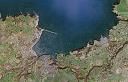
Fishguard Harbour is a large ferry port that can be entered in all conditions.
A quick glance at the chart will show that the protection within is not that good when the wind is hard from the north or north-east and swell enters the harbour. In all other wind directions you will be able to find good shelter.
Although the port is large the surrounding towns and villages are not, and although basic supplies and chandlery can be obtained, this is probably not the place to embark on major repairs.
There are two authorities for this harbour; the Ferry port is run by Stenna Lines and the Lower Fishguard harbour is run by Pembroke Council who run run it from Tenby with an assistant at Fishguard whose telephone number is given above.
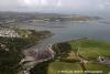
Treated as a passage anchorage, Lower Fishguard could be a useful stopover en route north or south. There is plenty of room to anchor in several locations away from the ferries, and vessels able to take the ground may be able to get a drying berth in the Lower Town, which is tucked away in the south-east corner and well recommended by this writer.
There are no alongside berths where you may remain afloat, and the place isn't really set up for yachts but the locals in the Lower Harbour were found to be very hospitable and prepared to dig out to help.
The mesh of blue floating rope which used to be a bug-bear of this harbour is now a thing of the past.
Approach
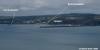
Approaches to Fishguard Bay are clear of obstruction, and the harbour can be entered at any state of the tide.
If approaching from the West the small craft skipper needs to be aware of the tidal disturbances at Strumble Bank and either give it a good offing, or keep inshore of the bank. More pilotage directions:
From a good distance off Strumble Head is conspicuous with its lighthouse (Fl(4)15s.45m.26M) and Dinas Head lying to the East of the entrance is relatively easy to identify, although it is not lit.
The end of the North breakwater(Fl.G.4.5s) and the East breakwater (Fl.R.3s) are lit to aid a night entry.
If approaching from the West and hugging the coast, once past Crincoed Point at a reasonable offing, making straight for the end of the Northern breakwater will clear the Cow and Calf rocks and islets. These project northwards from the root of the breakwater.
Otherwise the entrance is wide open (to you and any kind of swell from the N to the NE). Note the no anchoring restrictions that apply around the ferry port on the Goodwick side.
Berthing, Mooring & Anchoring
Fishguard actually consists of two harbours,
....... the ferry berths at Goodwick between the end of the East breakwater and the North breakwater, and the much smaller drying Lower Harbour in the south-east corner. Details:
Anchorages outside Lower Fishguard are best seen by reference to the chart. There are numbers of private moorings laid away from the no Anchorage area.. it's just a matter of anchoring to suit draft and current wind conditions. They also have seven conical yellow mooring buoys for visitors.
The Anchorage in the entrance to the Lower Harbour between Saddle Point and Castle Point is probably the most protected unless the wind is howling from the North West. Nose in to suit draft and tidal conditions if intending to remain afloat. Remember at low water neaps you will have up to 2 m more than shown on the chart, and even at low water springs you're likely to have almost a metre more. They now have seven buoys in that little bay outside the harbour but you need to do your sums if you can't take the ground.
If hoping to dry out alongside the pier in the Lower Harbour, or maybe to take the ground on the small beach deep within (see photo gallery), you will need to contact the local harbourmaster on 07721 860803 . An AB in the harbour will cost you £9.00 a night. Remember that, if you have taken the ground, you are restricting your options for departure time and need to work out whether it will be necessary to move out to deeper water on the tide before!
The plans for a marina on the Goodwick side have been dropped as Stenna pulled out of the deal. There are no longer any plans for the future of such a development.
Facilities
No fuel alongside, petrol and diesel by Jerry can from the seafront petrol station at Goodwick.
They now have shore power and a hose at the end of the pier in Lower Fishguard and this is included in the mooring fee.
There are public toilets and you can get a shower in the yacht club when it is open (most evenings as there is a lively youth section messing about in boats - and good for them!!)
Fishguard Bay Yacht Club is established at Lower Fishguard.
Provisioning can be accomplished either in Fishguard itself, which has a couple of supermarkets, or in Goodwick if you are anchored in that direction. Both locations have Post Offices. There are no shops adjacent to the harbour in Lower Fishguard; you have to climb the hill (which carries all the coastal traffic and is busy in the summer) to Fishguard itself. There is a "back way" up the hill - just follow the pathway around the SW corner from the hard standing where the locals keep their boats ashore and you'll find a quiet (if steep) walk through the trees up to the town.
Trailer Sailers have the choice of two slipways, the main ramp being the Goodwick Slipway which is a concrete slip, with access at about a quarter of the tidal range. Jet-skis are allowed but must do their speeding outside of the harbour area altogether.
The other ramp is in the Lower Harbour, which would allow access at less than a quarter the tidal range. Charges here are five pounds (harbourmaster 07721 860803), and it is tight of access.
Transport Links
Fishguard is at the end of the A40 which makes it's way to London, while Stena Line links the town to Rosslare, Ireland. There is a Railway Station at the Ferry Port.
History
Fishguard (Welsh: Abergwaun = "Mouth of the River Gwaun") is a coastal town in Pembrokeshire, south-west Wales, with a population of 3,300 (est. 2006). The community of Fishguard and Goodwick had a population of 5043 at the 2001 census. A regular ferry leaves for Rosslare in Ireland from the port of Fishguard Harbour (not actually in Fishguard, but a mile away at Goodwick). Fishguard is the terminus of the A40 London to Fishguard trunk road. It is in the Pembrokeshire Coast National Park and on the Pembrokeshire Coast Path. Fishguard is served by train at Fishguard Harbour railway station.
History
The name Fishguard is from old Norse "fish catching enclosure", and indicates that there may have been a Scandinavian trading post here, although there is no historical record to confirm this. It was once a marcher borough. Owen, in 1603, described it as one of five Pembrokeshire boroughs overseen by a portreeve. The Norman settlement lay along what is now High Street between the church at its north end and the slight remains of a Norman motte at its south end. Lower Fishguard developed as a herring fishery and port, trading with Ireland, Bristol and Liverpool. In the late 18th century it had 50 coasting vessels, and exported oats and salt herring. The port declined in the latter half of the 19th century.
Fishguard's ancient Royal Oak pub saw the signing of surrender following the Last Invasion of Britain in 1797 when a force of 1,400 French soldiers landed near Fishguard but surrendered two days later. The whole story is told by the Fishguard Tapestry, which was created for the 200th anniversary as a deliberate echo of the Bayeux Tapestry, and is on display in a hall near the town centre. The nineteenth century vicar of Fishguard, the Rev Samuel Fenton, wrote the noted book 'The History of Pembrokeshire'. The ancient Parliamentary Borough of Fishguard was contributary to the Borough of Haverfordwest. In 1907, it was created an Urban District, and included Goodwick from 1934 until the Urban District was abolished in 1974. During the Second World War, the Fishguard Bay Hotel was Station IXc of Special Operations Executive where submersibles were tested in Fishguard Bay.
Geography
Fishguard has a relatively mild climate due to its coastal position. The winds coming from the west or south-west have a determining influence on temperature and precipitation.
Wildlife around Fishguard is rich in flora and fauna: it shows a wide variety of colourful wild flowers and sea mammals including the grey seal, and even porpoises and dolphins. The local birdlife include Curlew, Redshank and Sanderling regularly foraging in the lower fishguard harbour and Stonechat.
Fishguard Harbour
The harbour was constructed by blasting 1.6 million tonnes of rock from the hillside to make a 900 m long breakwater. The quarried-out area became the quay. The harbour was finally opened on August 30, 1906. Planned to be the end of the Great Western Railway's line and its major sea port, replacing Neyland, problems with the harbour (known as Fishguard Harbour) prevented larger ocean liners from docking. Accordingly the harbour has a smaller inner breakwater protecting the remaining open side.
RMS Mauretania visited once in 1909 although passengers had to board by tender when transferring to and from the London train. The smaller breakwater was built as part of the preparations for the visit of the RMS Mauretania and is sometimes known as the "Mauretania Mole". The breakwater lead to unanticipated silting, and the prospect of future visits from larger liners was abandoned. Directly above the harbour is a small estate known as "Harbour Village", built to house workers during the construction of the harbour.
The port now accommodates a ferry and seasonal fast catamaran service to Rosslare operated by Stena Line.
The RNLI operate an all weather Trent class lifeboat, the Blue Peter VII, and a class D inshore lifeboat from within the harbour.
The text on this HISTORY page is covered by the following licence
http://en.wikipedia.org/wiki/Wikipedia:Text_of_the_GNU_Free_Documentation_License
Eating, Drinking & Entertainment
For the skipper prepared to abandon his boat at anchor a foray ashore will root out a few eating and drinking places. Not a vast choice in Fishguard, but there is an Indian restaurant, and various pubs that serve food. If you dry out alongside in the Lower Harbour the Fishguard Bay Yacht Club is virtally at the top of the ladder and when they are open you are made very welcome; they have a bar and showers.
The links below may give you some ideas:
Businesses in Fishguard
http://www.fishguardonline.com/business.html
Pubs in Goodwick
http://www.beerintheevening.com/pubs/results.shtml/el/Goodwick%3BDyfed/
Pubs in Fishguard
Links
|

Got a comment to make about Fishguard ? Have you found this coverage helpful ? HAVE YOUR SAY (your email address will always be kept private)
Your Ratings & Comments
all Repairs and Supplies