

Harbour Information (use the  icons to find out more)

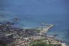
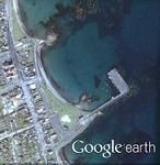
Ballywalter Harbour
Your Comments: 6 Read or add your comments
Courtesy Flag
Flag, Red EnsignWaypoint
54° 32.65 N 005° 26.2 WCharts
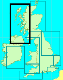
AC2156 East Coast & Strangford Lough, SC5612 Portavogie to Ballywalter, Imray C62 Irish SeaRules & Regulations
None KnownHazards
Skulmartin Rock Posn 54° 32.327’N, 005° 27.154’W Unlit Beacon stands above rocks which are awash at half tide.Tidal Data Times & Range
HW as Dover. MHWS 4.7m MHWN 3.9m MLWN 1.4m MLWS 0.6This site is designed for slower, roaming broadband connections, like you would get at sea, so it needs JavaScript enabled to expand the text.
General Description
Contacts The harbour comes under the control of the HM at Donaghadee 02891 882377 but the day to day running of the harbour is left to the incumbants. There's no point in phoning the HM to book a berth as he'll have no idea what's in or out at the time you call!! ... read more
Approach
Off the Skulmartin Rock the rates are up to about 2.5 knots springs and.... ... read more
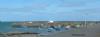
Berthing, Mooring & Anchoring
This has been dealt with above. There are no harbour dues here. ... read more
Your Ratings & Comments
6 comments
UPDATE JULY 2022
Written by Don Thomson 3 | 27th Jul 2022
No changes
Update Early Summer 2021
Written by Don Thomson 3 | 17th Jun 2021
No changes
Update Spring 2019
Written by Don Thomson 3 | 1st May 2019
These notes were reviewed in May 2019. We've uploaded a new chart.
UPDATE APRIL 2017
Written by Don Thomson | 5th Apr 2017
These notes were reviewed by Don in April 2107. There are no signs that this harbour is being developed as a leisure destination
Update 2015
Written by dononshytalk | 17th Mar 2015
These notes were reviewed by Don in March 2015. No changes
Update November 2013
Written by dononshytalk | 4th Nov 2013
These notes were reviewed by Don Thomson in November 2013. There are no changes apart from the closure of the petrol station

© visitMyHarbour.com | website design created by Black Culm Ltd