

Harbour Information (use the  icons to find out more)


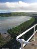
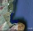
Cushendun Harbour, Cushendall and Red Bay
Your Comments: 5 Read or add your comments
Courtesy Flag
Flag, Red EnsignWaypoint
NoneCharts
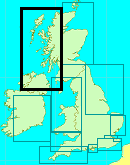
AC 2199 North Channel South Part, SC5612 – 14, Larne Lough to Cushendun Bay, Imray C64 Belfast Lough to Lough Foyle and CrinanRules & Regulations
None KnownHazards
Strong TidesTidal Data Times & Range
High Water is Dover + 0015 MHWS 1.6 MHWN 1.5 MLWN 0.3 MLWS 0.2 See Approach and Entry section. (links)This site is designed for slower, roaming broadband connections, like you would get at sea, so it needs JavaScript enabled to expand the text.
General Description
Contacts : Belfast Coastguard Channel 16
These two anchorages are extremely useful if one is caught out..... ... read more
Approach
There are no problems approaching this coast, just work the tides and...... ... read more
Berthing, Mooring & Anchoring
The only place to tie up inside is at Red Bay Pier and that is a fairly rough construction with large piers. ... read more
Your Ratings & Comments
5 comments
UPDATE JULY 2022
Written by Don Thomson 3 | 29th Jul 2022
No changes
Update Early Summer 2021
Written by Don Thomson 3 | 24th Jun 2021
No changes
Update Spring 2019
Written by Don Thomson 3 | 7th May 2019
These notes were reviewed in May 2019. A new chart has been uploaded
UPDATE APRIL 2017
Written by Don Thomson | 6th Apr 2017
No changes
Update 2015
Written by dononshytalk | 20th Mar 2015
These notes were reviewed by Don in March 2015. No changes

© visitMyHarbour.com | website design created by Black Culm Ltd